Country:
Region:
City:
Latitude and Longitude:
Time Zone:
Postal Code:
IP information under different IP Channel
ip-api
Country
Region
City
ASN
Time Zone
ISP
Blacklist
Proxy
Latitude
Longitude
Postal
Route
Luminati
Country
Region
kkc
City
kowlooncity
ASN
Time Zone
Asia/Hong_Kong
ISP
HKBN Enterprise Solutions HK Limited
Latitude
Longitude
Postal
IPinfo
Country
Region
City
ASN
Time Zone
ISP
Blacklist
Proxy
Latitude
Longitude
Postal
Route
db-ip
Country
Region
City
ASN
Time Zone
ISP
Blacklist
Proxy
Latitude
Longitude
Postal
Route
ipdata
Country
Region
City
ASN
Time Zone
ISP
Blacklist
Proxy
Latitude
Longitude
Postal
Route
Popular places and events near this IP address

Wong Tai Sin District
District in Hong Kong, China
Distance: Approx. 424 meters
Latitude and longitude: 22.33353,114.19686
Wong Tai Sin District is one of the 18 districts of Hong Kong. It is the only landlocked district in Hong Kong. It is located in Kowloon, and is the northernmost district in Kowloon.

San Po Kong
Industrial and residential area of Hong Kong
Distance: Approx. 172 meters
Latitude and longitude: 22.33547,114.19837
San Po Kong (Chinese: 新蒲崗; Cantonese Yale: sān pòuh gōng) is an area in New Kowloon in Hong Kong. It is largely industrial and partly residential. Administratively, it belongs to Wong Tai Sin District.

Diamond Hill station
MTR station in Kowloon, Hong Kong
Distance: Approx. 478 meters
Latitude and longitude: 22.3401,114.2016
Diamond Hill (Chinese: 鑽石山; Cantonese Yale: Jyun sehk sāan) is an MTR station located in Tai Hom, Northern Kowloon, named for local Diamond Hill area. It is an interchange station on the Kwun Tong line and Tuen Ma line. The station is incorporated into the large Plaza Hollywood development.

Ho Lap College
Public school in Kowloon, Hong Kong
Distance: Approx. 452 meters
Latitude and longitude: 22.33666667,114.19555556
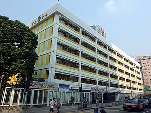
Ho Lap College (Chinese: 可立中學), HLC, is a band 1 grant-aided co-educational EMI school in San Po Kong, Kowloon, Hong Kong.

Ngau Chi Wan
Distance: Approx. 308 meters
Latitude and longitude: 22.33333333,114.2
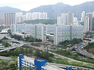
Ngau Chi Wan (Chinese: 牛池灣) was a bay beneath Hammer Hill in New Kowloon, Hong Kong. It now refers to an area where Choi Hung Estate is situated.

Stone House (Diamond Hill)
Distance: Approx. 388 meters
Latitude and longitude: 22.339577,114.200188
The Stone House is one of the three 'Treasures of Tai Hom Village' (大磡村三寶), the three remaining structures from the former Tai Hom squatter village demolished in 2001. The building is located at No. 4 Tai Koon Yuen (大觀園), Tai Hom, in the Wong Tai Sin District of Kowloon, Hong Kong, China.
Lower Wong Tai Sin Estate
Public housing estate in Wong Tai Sin, Hong Kong
Distance: Approx. 533 meters
Latitude and longitude: 22.3383,114.1953
Lower Wong Tai Sin Estate (Chinese: 黃大仙下邨) is a public housing estate and Tenants Purchase Scheme estate in Wong Tai Sin, Kowloon, Hong Kong, along the south of Lung Cheung Road, near Wong Tai Sin Temple and MTR Wong Tai Sin station. It is divided into Lower Wong Tai Sin (I) Estate (黃大仙下(一)邨) and Lower Wong Tai Sin (II) Estate (黃大仙下(二)邨). After redevelopment, the estate consists of a total of 24 blocks built between the 1980s and 1990s.

Tai Hom Village
Village in Kowloon, Hong Kong
Distance: Approx. 380 meters
Latitude and longitude: 22.339428,114.200733
Tai Hom Village (Chinese: 大磡村) was the largest squatter village in Kowloon, Hong Kong. Its demolition was completed in 2001, with a few structures of historical value being preserved. The name is still used to designate its former site in Wong Tai Sin District, which is awaiting redevelopment.

Po Leung Kuk Stanley Ho Sau Nan Primary School
Primary school in Hong Kong
Distance: Approx. 348 meters
Latitude and longitude: 22.3351,114.1967
Po Leung Kuk Stanley Ho Sau Nan Primary School (Chinese: 保良局何壽南小學) is a primary school located in Kai Tak, Kowloon City, in Hong Kong. It is a co-ed primary school using Chinese as the medium of instruction established by the Po Leung Kuk in 1971. There are 24 classes in total, four for each year, and with approximately 40 students in a class, giving approximately 960 students in total.

Rhythm Garden
Distance: Approx. 258 meters
Latitude and longitude: 22.3363,114.202397
Rhythm Garden (Chinese: 采頤花園) is a Home Ownership Scheme and Private Sector Participation Scheme court in San Po Kong, Wong Tai Sin District, Kowloon, Hong Kong, jointly developed by the Hong Kong Housing Authority and New World Development. Formerly a part of the site of former British Forces Overseas Hong Kong's Blackdown Barracks, the court has 12 blocks completed in 2000.

Choi Hung Road Playground
Park in Kowloon, Hong Kong
Distance: Approx. 375 meters
Latitude and longitude: 22.338104,114.196975
Choi Hung Road Playground (Chinese: 彩虹道遊樂場) is located in Choi Hung Road, San Po Kong, Wong Tai Sin District, Kowloon, Hong Kong. The playground is managed by the Leisure and Cultural Services Department of Hong Kong.

Mikiki
Shopping mall in San Po Kong, Kowloon
Distance: Approx. 416 meters
Latitude and longitude: 22.3337,114.1968
Mikiki is a shopping centre in San Po Kong, Kowloon, Hong Kong. It is owned by Sun Hung Kai Properties. Mikiki is directly connected to The Latitude, a private housing estate that was also developed by Sun Hung Kai Properties.
Weather in this IP's area
light rain
25 Celsius
26 Celsius
24 Celsius
26 Celsius
1019 hPa
68 %
1019 hPa
1016 hPa
10000 meters
4.47 m/s
50 degree
46 %
06:29:34
17:43:59
