Country:
Region:
City:
Latitude and Longitude:
Time Zone:
Postal Code:
IP information under different IP Channel
ip-api
Country
Region
City
ASN
Time Zone
ISP
Blacklist
Proxy
Latitude
Longitude
Postal
Route
Luminati
Country
Region
11
City
seodaemungu
ASN
Time Zone
Asia/Seoul
ISP
National Infomation Society Agency
Latitude
Longitude
Postal
IPinfo
Country
Region
City
ASN
Time Zone
ISP
Blacklist
Proxy
Latitude
Longitude
Postal
Route
db-ip
Country
Region
City
ASN
Time Zone
ISP
Blacklist
Proxy
Latitude
Longitude
Postal
Route
ipdata
Country
Region
City
ASN
Time Zone
ISP
Blacklist
Proxy
Latitude
Longitude
Postal
Route
Popular places and events near this IP address
Sogang University
University in Seoul, South Korea
Distance: Approx. 579 meters
Latitude and longitude: 37.55111111,126.94111111
Sogang University (SU, Korean: 서강대학교; lit. West River University) is a private research university in Seoul, South Korea. It was established in 1960 by Fr.

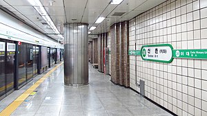
Sinchon station
Metro station on Seoul Metro Line 2
Distance: Approx. 20 meters
Latitude and longitude: 37.55527778,126.93694444
Sinchon Station is a station on Line 2 of the Seoul Metropolitan Subway in Mapo-gu, north of the Han River. It is located between Hongik University Station and Ewha Womans University Station. It is the closest station to Sogang University, Yonsei University, Hyundai Department Store Sinchon, and Seoul Korea Temple.

Ewha Womans University station
Subway station in Seoul, South Korea
Distance: Approx. 807 meters
Latitude and longitude: 37.55666667,126.94583333
Ewha Womans University (Korean: 이대역; RR: Idae-yeok) is a station on the Line 2 of the Seoul Metropolitan Subway. As its name indicates, it serves the nearby Ewha Womans University, although Sinchon Station on the Gyeongui-Jungang Line is closer to the school.
Seoul Korea Temple
Latter-day Saints Temple in South Korea
Distance: Approx. 655 meters
Latitude and longitude: 37.558957,126.931301
The Seoul Korea Temple (Korean: 한국 서울 성전) is the 37th operating temple of the Church of Jesus Christ of Latter-day Saints (LDS Church).

Severance Hospital
Hospital in Seoul, South Korea
Distance: Approx. 886 meters
Latitude and longitude: 37.5624,126.9409
Severance Hospital is a teaching hospital located in Sinchon-dong, Seodaemun District, South Korea. It is one of the oldest and biggest university hospitals in South Korea. It has 2,437 beds and treats approximately 2,500,000 outpatients and 840,000 inpatients annually.

Daeheung station
Train station in South Korea
Distance: Approx. 941 meters
Latitude and longitude: 37.54777778,126.94222222
Daeheung station is a subway station on Seoul Subway Line 6 in Seoul, South Korea.
Changcheon-dong
Place in South Korea
Distance: Approx. 364 meters
Latitude and longitude: 37.558,126.935
Changcheon-dong (Korean: 창천동) is a dong (neighborhood) of Seodaemun District, Seoul, South Korea. It is home to the only Mormon Temple in the country. The Synnara Record Shop in Changcheon was one of the main filming locations for Seoul Broadcasting System's 2001 drama Beautiful Days, starring Lee Byung-hun, Choi Ji-woo, Ryu Si-won, Shin Min-a, Lee Jung-hyun and Lee Yoo-jin The area also features a 66 m2 store of the Korean cosmetics brand Skin Food, which has been open since June 2004.
Changjeon-dong
Place in South Korea
Distance: Approx. 770 meters
Latitude and longitude: 37.55,126.931
Changjeon-dong (Korean: 창전동) is a legal dong (neighborhood) of Mapo District, Seoul, South Korea. It was merged with Sangsu-dong into Seogang-dong in January 2007.

Sogang University station
Station of the Seoul Metropolitan Subway
Distance: Approx. 356 meters
Latitude and longitude: 37.552132,126.935389
Sogang University Station is a station on the Gyeongui–Jungang Line in Seoul, South Korea. Seogang Station was renamed Sogang University Station on March 17, 2014.

Sinchon Station (Gyeongui Line)
Train station on Gyeongui Line in Seodaemun-gu, Seoul, South Korea
Distance: Approx. 743 meters
Latitude and longitude: 37.5597,126.943
Sinchon Station is a station on the Gyeongui–Jungang Line. It was opened as a train station in 1921 and Seoul Metro traffic commenced in 2009.

Sinchon
Region of Seoul, South Korea
Distance: Approx. 49 meters
Latitude and longitude: 37.55527,126.937412
Sinchon (Korean: 신촌) is a region of South Korea surrounding Sinchon-dong, Changcheon-dong, Nogosan-dong and Daeheung-dong. It is known for its numerous universities including Yonsei University, Ewha Womans University, Sogang University, Hongik University, as well as its vibrant nightlife.
Chejungwon
Hospital in South Korea
Distance: Approx. 887 meters
Latitude and longitude: 37.56291667,126.93883333
Chejungwon (Korean: 제중원; Hanja: 濟衆院) is a medical institution in Seoul, South Korea that is affiliated with the Yonsei University Health System. It was founded in 1885, and is considered the first Western medical institution in Korea. It became affiliated with Yonhee University, the predecessor to Yonsei University, in 1957.
Weather in this IP's area
clear sky
20 Celsius
20 Celsius
18 Celsius
21 Celsius
1017 hPa
60 %
1017 hPa
1013 hPa
10000 meters
4.12 m/s
150 degree
07:13:06
17:21:11