Country:
 Japan
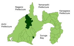
JapanRegion:
City:
Latitude and Longitude:
Time Zone:
Postal Code:
IP information under different IP Channel
ip-api
Country
Region
City
ASN
Time Zone
ISP
Blacklist
Proxy
Latitude
Longitude
Postal
Route
IPinfo
Country
Region
City
ASN
Time Zone
ISP
Blacklist
Proxy
Latitude
Longitude
Postal
Route
MaxMind
Country
Region
City
ASN
Time Zone
ISP
Blacklist
Proxy
Latitude
Longitude
Postal
Route
Luminati
Country
JPRegion
22
City
shimada
ASN
Time Zone
Asia/Tokyo
ISP
TOKAI Communications Corporation
Latitude
Longitude
Postal
db-ip
Country
Region
City
ASN
Time Zone
ISP
Blacklist
Proxy
Latitude
Longitude
Postal
Route
ipdata
Country
Region
City
ASN
Time Zone
ISP
Blacklist
Proxy
Latitude
Longitude
Postal
Route
Popular places and events near this IP address

Shimada, Shizuoka
City in Chūbu, Japan
Distance: Approx. 3567 meters
Latitude and longitude: 34.83627778,138.19272222
Shimada (島田市, Shimada-shi) is a city located in Shizuoka Prefecture, Japan. The city, which covers an area of 315.7 square kilometres (121.9 sq mi), had an estimated population in September 2023 of 93,724, giving a population density of About 300 persons per km2.

Fujieda, Shizuoka
City in Chūbu, Japan
Distance: Approx. 6032 meters
Latitude and longitude: 34.86741667,138.25772222
Fujieda (藤枝市, Fujieda-shi) is a city located in Shizuoka Prefecture, Japan. As of 30 April 2019, the city has an estimated population of 145,032 in 59,480 households, and a population density of 750 persons per km2. The total area of the city was 194.06 square kilometres (74.93 sq mi).

Ōigawa, Shizuoka
Former municipality in Chūbu, Japan
Distance: Approx. 5668 meters
Latitude and longitude: 34.8,138.28333333
Ōigawa (大井川町, Ōigawa-chō) was a town located in Shida District, Shizuoka Prefecture, Japan. As of 2008, the town had an estimated population of 22,695 and a density of 962.92 persons per km2. The total area was 24.54 km2.

Yoshida, Shizuoka
Town in Japan
Distance: Approx. 6302 meters
Latitude and longitude: 34.76666667,138.25
Yoshida (吉田町, Yoshida-chō) is a town located in Haibara District, southern Shizuoka Prefecture, Japan. As of 1 August 2019, the town had an estimated population of 29,593 in 11359 households, and a population density of 1400 persons per km². The total area of the town is 20.73 square kilometres (8.00 sq mi).
Haibara District, Shizuoka
Distance: Approx. 6067 meters
Latitude and longitude: 34.769487,138.251717
Haibara (榛原郡, Haibara-gun) is a rural district located in Shizuoka Prefecture, Japan. As of July 2012, the district has an estimated population of 37,550 and a population density of 72.6 persons per km2. The total area was 517.56 km2.

Shizuoka Airport
Airport in Japan
Distance: Approx. 4271 meters
Latitude and longitude: 34.79611111,138.18944444
Shizuoka Airport (静岡空港, Shizuoka Kūkō) (IATA: FSZ, ICAO: RJNS), also called Mt. Fuji Shizuoka Airport, is located in Shizuoka Prefecture, Japan. Opened on June 4, 2009, the airport has domestic service to Sapporo, Fukuoka, Naha (Okinawa), Komatsu, Kumamoto, and Kagoshima.

Shimada-juku
Twenty-third of the 53 stations of the Tōkaidō in Japan
Distance: Approx. 5761 meters
Latitude and longitude: 34.83472222,138.16583333
Shimada-juku (島田宿, Shimada-juku) was the twenty-third of the fifty-three stations of the Tōkaidō highway, which connected Edo with Kyoto in premodern Japan. It is located in what is now part of Shimada, Shizuoka Prefecture, Japan.

Hōrai Bridge
Bridge in Shizuoka, Japan
Distance: Approx. 3659 meters
Latitude and longitude: 34.82139,138.186213
The Hōrai Bridge (蓬莱橋, Hōrai-bashi) is a wooden pedestrian bridge over the Ōi River located in the city of Shimada, Shizuoka, Japan. It was constructed in 1879 and rebuilt after a flood in the 1960s. With a length of 897.422 metres (2,944.30 ft), the bridge was registered in The Guinness Book of Records as the longest wooden walking bridge in the world in 1997.

Fujieda Station
Railway station in Fujieda, Shizuoka Prefecture, Japan
Distance: Approx. 4082 meters
Latitude and longitude: 34.84944444,138.2525
Fujieda Station (藤枝駅, Fujieda-eki) is a railway station in Fujieda, Shizuoka Prefecture, Japan, operated by Central Japan Railway Company (JR Tōkai).

Rokugō Station
Railway station in Shimada, Shizuoka Prefecture, Japan
Distance: Approx. 2770 meters
Latitude and longitude: 34.83638889,138.20361111
Rokugō Station (六合駅, Rokugō-eki) is a railway station in Shimada, Shizuoka Prefecture, Japan, operated by Central Japan Railway Company (JR Tōkai).

Shimada Station
Railway station in Shimada, Shizuoka Prefecture, Japan
Distance: Approx. 4896 meters
Latitude and longitude: 34.83027778,138.17416667
Shimada Station (島田駅, Shimada-eki) is a railway station in the city of Shimada, Shizuoka Prefecture, Japan, operated by Central Japan Railway Company (JR Tōkai). The station is also a freight depot for the Japan Freight Railway Company (JR Freight).

Shida Gunga ruins
Archeological site
Distance: Approx. 4948 meters
Latitude and longitude: 34.86213333,138.242725
The Shida Gunga ruins (志太郡衙跡, Shida-gunga-ato) is an archaeological site containing the ruins of the Nara to early Heian period government administrative complex for Shiga District , Suruga Province, located in the Minamisurugadai neighborhood of the city of Fujieda, Shizuoka in the Tōkai region of Japan. The site was designated a National Historic Site of Japan in 1980. Gunga are ancient Japanese administrative buildings.
Weather in this IP's area
broken clouds
28 Celsius
32 Celsius
28 Celsius
29 Celsius
1011 hPa
77 %
1011 hPa
1007 hPa
10000 meters
5.66 m/s
250 degree
75 %
05:55:56
17:07:53