Country:
 Japan
JapanRegion:
City:
Latitude and Longitude:
Time Zone:
Postal Code:
IP information under different IP Channel
ip-api
Country
Region
City
ASN
Time Zone
ISP
Blacklist
Proxy
Latitude
Longitude
Postal
Route
IPinfo
Country
Region
City
ASN
Time Zone
ISP
Blacklist
Proxy
Latitude
Longitude
Postal
Route
MaxMind
Country
Region
City
ASN
Time Zone
ISP
Blacklist
Proxy
Latitude
Longitude
Postal
Route
Luminati
Country
JPASN
Time Zone
Asia/Tokyo
ISP
AZT
Latitude
Longitude
Postal
db-ip
Country
Region
City
ASN
Time Zone
ISP
Blacklist
Proxy
Latitude
Longitude
Postal
Route
ipdata
Country
Region
City
ASN
Time Zone
ISP
Blacklist
Proxy
Latitude
Longitude
Postal
Route
Popular places and events near this IP address

Okachimachi Station
Railway station in Tokyo, Japan
Distance: Approx. 281 meters
Latitude and longitude: 35.707327,139.774847
Okachimachi Station (御徒町駅, Okachimachi-eki) is a railway station in Taito, Tokyo, Japan, operated by East Japan Railway Company (JR East).

Yushima Station (Tokyo)
Metro station in Tokyo, Japan
Distance: Approx. 405 meters
Latitude and longitude: 35.707954,139.769933
Yushima Station (湯島駅, Yushima-eki) is a subway station on the Tokyo Metro Chiyoda Line in the Bunkyo-ku, Tokyo, Japan, operated by the Tokyo subway operator Tokyo Metro. It is located near Shinobazu Pond and Ueno Park.
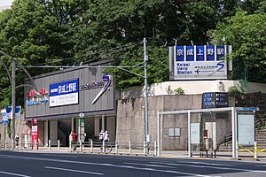
Keisei Ueno Station
Railway station in Tokyo, Japan
Distance: Approx. 655 meters
Latitude and longitude: 35.71116,139.773683
Keisei Ueno Station (京成上野駅, Keisei-Ueno-eki) is a railway station in Taitō, Tokyo, Japan, operated by the private railway operator Keisei Electric Railway. It is the terminus of the Keisei Main Line and is a short distance from JR Ueno Station.

Suehirocho Station (Tokyo)
Metro station in Tokyo, Japan
Distance: Approx. 286 meters
Latitude and longitude: 35.702962,139.771671
Suehirocho Station (末広町駅, Suehirochō-eki) is a subway station on the Tokyo Metro Ginza Line in Chiyoda, Tokyo, Japan, operated by the Tokyo subway operator Tokyo Metro. It is numbered "G-14".

Shinobazu Pond
Pond in Ueno Park, Tokyo, Japan
Distance: Approx. 730 meters
Latitude and longitude: 35.71138889,139.77
The Shinobazu Pond (不忍池, Shinobazu no Ike) is a pond within Ueno Park (a spacious public park located in the Ueno section of Taitō, Tokyo, Japan), and a historically prominent Shitamachi feature often appearing in history and works of art. The park occupies the site of the former Kan'ei-ji, a temple closely associated with the Tokugawa shōguns, who had built it to guard Edo Castle against the northeast, a direction believed to be unlucky by traditional geomancy. The temple was destroyed during the Boshin War.

Kanda Shrine
Shinto shrine in Tokyo, Japan
Distance: Approx. 601 meters
Latitude and longitude: 35.70194444,139.76777778
Kanda Shrine (神田明神, Kanda-myōjin, officially 神田神社 Kanda-jinja), is a Shinto shrine located in Chiyoda, Tokyo, Japan. The shrine dates back 1,270 years, but the current structure was rebuilt several times due to fire and earthquakes. It is situated in one of the most expensive estate areas of Tokyo.
Digital Hollywood University
Private university in Chiyoda, Japan
Distance: Approx. 685 meters
Latitude and longitude: 35.69919444,139.77208333
Digital Hollywood University (デジタルハリウッド大学, Dejitaru hariuddo daigaku) is a private university in Chiyoda, Tokyo, Japan. The predecessor of the school was founded in 1994, and it was chartered as a university on April 1, 2005 by Digital Hollywood Corporation, a school establishment corporation based on the Act on Special Districts for Structural Reform. The school specializes in film, animation, and video game design, part of a growing number of such schools in Japan.

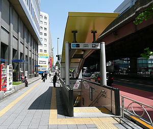
Ueno-hirokoji Station
Metro station in Tokyo, Japan
Distance: Approx. 299 meters
Latitude and longitude: 35.707985,139.773061
Ueno-hirokoji Station (上野広小路駅, Ueno-hirokōji-eki) is a subway station on the Tokyo Metro Ginza Line, in Taitō, Tokyo, Japan, operated by the Tokyo subway operator Tokyo Metro. It is numbered "G-15".
Naka-okachimachi Station
Metro station in Tokyo, Japan
Distance: Approx. 298 meters
Latitude and longitude: 35.7064,139.776
Naka-okachimachi Station (仲御徒町駅, Naka-okachimachi-eki) is a subway station on the Hibiya Line in Taitō, Tokyo, Japan, operated by the Tokyo subway operator Tokyo Metro.

Ueno-okachimachi Station
Distance: Approx. 313 meters
Latitude and longitude: 35.707894,139.774337
Ueno-okachimachi Station (上野御徒町駅, Ueno-okachimachi-eki) is a subway station in Taitō, Tokyo, Japan, operated by the Tokyo subway operator Toei Subway. It is numbered E-09.

Yushima Tenmangū
Shinto shrine in Tokyo, Japan
Distance: Approx. 503 meters
Latitude and longitude: 35.70777778,139.76833333
Yushima Tenman-gū (湯島天満宮) is a Shinto shrine located in the Bunkyō ward of Tokyo, Japan. Established in 458, it is now devoted to Tenjin, the kami of Learning. For this reason, it is also called Yushima Tenjin.

Kyū-Iwasaki-tei Garden
Distance: Approx. 681 meters
Latitude and longitude: 35.70972222,139.76777778
Kyū-Iwasaki-tei Garden (旧岩崎邸庭園, Kyū-Iwasaki-tei teien, Gardens of Old Iwasaki Mansion) is located in Taitō, Tokyo. It is the former estate of the Iwasaki clan who were the founders of Mitsubishi. The premises have three buildings: a Western-style house designed by British architect Josiah Conder, a Japanese house and a billiard house, and cover an area of about 17,000 square metres.
Weather in this IP's area
few clouds
28 Celsius
31 Celsius
26 Celsius
29 Celsius
1017 hPa
77 %
1017 hPa
1015 hPa
8000 meters
2.06 m/s
110 degree
20 %
05:25:00
17:46:05