Country:
 Thailand
Region:
City:
Latitude and Longitude:
Time Zone:
Postal Code:
IP information under different IP Channel
ip-api
Country
Region
City
ASN
Time Zone
ISP
Blacklist
Proxy
Latitude
Longitude
Postal
Route
IPinfo
Country
Region
City
ASN
Time Zone
ISP
Blacklist
Proxy
Latitude
Longitude
Postal
Route
MaxMind
Country
Region
City
ASN
Time Zone
ISP
Blacklist
Proxy
Latitude
Longitude
Postal
Route
Luminati
Country
THASN
Time Zone
Asia/Bangkok
ISP
JasTel Network International Gateway
Latitude
Longitude
Postal
db-ip
Country
Region
City
ASN
Time Zone
ISP
Blacklist
Proxy
Latitude
Longitude
Postal
Route
ipdata
Country
Region
City
ASN
Time Zone
ISP
Blacklist
Proxy
Latitude
Longitude
Postal
Route
Popular places and events near this IP address
Joint Graduate School of Energy and Environment
Distance: Approx. 491 meters
Latitude and longitude: 13.648933,100.493247
The Joint Graduate School of Energy and Environment (JGSEE) (Thai: บัณฑิตวิทยาลัยร่วมด้านพลังงานและสิ่งแวดล้อม) is an autonomous graduate school, operating as a consortium of five Thai universities. Established in 1998, it aims to be an internationally recognized premier centre in graduate education and research in the fields of energy and environmental technologies. The school receives funding from the Thai government through the CHE–ADB Higher Education Development Project and the Energy Conservation Promotion Fund of Thailand's Ministry of Energy.

Rat Burana district
Khet in Bangkok, Thailand
Distance: Approx. 3959 meters
Latitude and longitude: 13.68222222,100.50555556
Rat Burana (Thai: ราษฎร์บูรณะ, pronounced [râːt būːrānáʔ]) is one of the 50 districts (khet) of Bangkok, Thailand. The district is bounded by (clockwise from east to north) Phra Pradaeng of Samut Prakan province, Thung Khru, Chom Thong and Thon Buri districts of Bangkok while its north to east is Chao Phraya River with (clockwise) Bang Kho Laem and Yan Nawa districts across the river.
Chom Thong district, Bangkok
Khet in Bangkok, Thailand
Distance: Approx. 3010 meters
Latitude and longitude: 13.67722222,100.48472222
Chom Thong (Thai: จอมทอง, pronounced [t͡ɕɔ̄ːm tʰɔ̄ːŋ]) is one of the 50 districts (khet) of Bangkok, Thailand. The district is bounded by the districts (clockwise from north) Phasi Charoen, Thon Buri, Rat Burana, Thung Khru, Bang Khun Thian, and Bang Bon.
King Mongkut's University of Technology Thonburi
University
Distance: Approx. 721 meters
Latitude and longitude: 13.65166667,100.49555556
The King Mongkut's University of Technology Thonburi (KMUTT, Thai: มหาวิทยาลัยเทคโนโลยีพระจอมเกล้าธนบุรี; RTGS: maha witthayalai theknoloyi phrachomklao thonburi; colloquially "Bangmod", Thai: บางมด; RTGS: bang mot) is a national public engineering and technology university in Thailand, focusing on teaching and research. It is one of nine national research universities (NRU) in Thailand. It is in Bang Mot Sub-district, Thung Khru District, Bangkok.
Bangpakok Wittayakom School
Public school in Bangkok, Thailand
Distance: Approx. 3681 meters
Latitude and longitude: 13.683042,100.495063
"Bangpakok Wittayakom School" (Thai: โรงเรียนบางปะกอกวิทยาคม) is a public school located in Bangkok, Thailand. The school admits secondary students, grades 7 to 12, aged 11–18. The previous name of the school was Mattayom Wat Bangpakok School.
Wat Putthabucha School
Public secondary school in Bangkok, Thailand
Distance: Approx. 1509 meters
Latitude and longitude: 13.65098,100.475063
Wat Putthabucha School (Thai: โรงเรียนวัดพุทธบูชา) is a public school located in Bangkok, Thailand. The school admits secondary students, grades 7 to 12, aged 11–18. The previous name of this school is 'Putthabucha Wittayakom'.

72nd Anniversary Stadium (Bang Mod)
Distance: Approx. 591 meters
Latitude and longitude: 13.64666667,100.49277778
60th Anniversary Stadium (Bang Mod) or Chalerm Phrakiat Bang Mod Stadium (Thai: สนามกีฬาเฉลิมพระเกียรติ 60 พรรษา บางมด) is a multi-purpose stadium in Thung Khru, Bangkok, Thailand. The stadium built for celebration of the 60th Birthday Anniversary of King Bhumibol Adulyadej, hence the name of the venue. It is currently used mostly for football matches and is the home stadium of Bangkok.
Darunsikkhalai School for Innovative Learning
Distance: Approx. 651 meters
Latitude and longitude: 13.649972,100.494996
Darunsikkhalai School for Innovative Learning (Thai: ดรุณสิกขาลัย โรงเรียนนวัตกรรมแห่งการเรียนรู้) (also, "DSIL", "Darun") is a bilingual school located in King Mongkut's University of Technology Thonburi. DSIL is Thailand’s first school that follows the Constructionism Theory as the school curriculum. DSIL was founded in 1997 and has a variety of connections to educational institutions, such as Stanford University, Massachusetts Institute of Technology (MIT), etc.

Thonburirom Park
Distance: Approx. 284 meters
Latitude and longitude: 13.6519,100.4912
Thonburirom Park (Thai: สวนธนบุรีรมย์, RTGS: Suan Thon Buri Rom, pronounced [sǔa̯n tʰōn bū.rīː rōm]), widely known as Suan Thon (สวนธน), is the first public park in Thonburi, Bangkok, Thailand. The park offers rare open public space, trees, and playgrounds. It has a total land area of 63 rai (ไร่) and is located along Puttabucha Road, Bang Mod, Thung Kru district.
Suankularb Wittayalai Thonburi School
Public secondary school in Bangkhunthein District, Bangkok, Thailand
Distance: Approx. 3340 meters
Latitude and longitude: 13.626781,100.470095
Suankularb Wittayalai Thonburi School (S.K.T.) (Thai: โรงเรียนสวนกุหลาบวิทยาลัย ธนบุรี) is the tenth school affiliated with Suankularb Wittayalai. The school is a high school for grades 7 through 12 in Thailand under the management of Mr. Pisanu Sripol, the first director of the school.
Bang Kho Laem subdistrict
Khwaeng in Thailand
Distance: Approx. 4777 meters
Latitude and longitude: 13.69333333,100.49166667
Bang Kho Laem (Thai: บางคอแหลม, pronounced [bāːŋ kʰɔ̄ː lɛ̌ːm]) is a khwaeng (subdistrict) of Bang Kho Laem District, in Bangkok, Thailand. In 2020, it had a total population of 22,697 people.

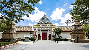
Wat Prasert Sutthawat
Distance: Approx. 3617 meters
Latitude and longitude: 13.679722,100.503611
Wat Prasert Sutthawat, also written as Wat Prasoet Sutthawat (Thai: วัดประเสริฐสุทธาวาส), often abbreviated to Wat Prasert (วัดประเสริฐ) is an ancient Thai Buddhist temple in Bangkok.
Weather in this IP's area
overcast clouds
28 Celsius
33 Celsius
27 Celsius
28 Celsius
1009 hPa
90 %
1009 hPa
1008 hPa
10000 meters
2.31 m/s
3.29 m/s
300 degree
100 %
06:08:11
18:00:31