116.102.98.195 - IP Lookup: Free IP Address Lookup, Postal Code Lookup, IP Location Lookup, IP ASN, Public IP
Country:
Region:
City:
Location:
Time Zone:
Postal Code:
ISP:
ASN:
language:
User-Agent:
Proxy IP:
Blacklist:
IP information under different IP Channel
ip-api
Country
Region
City
ASN
Time Zone
ISP
Blacklist
Proxy
Latitude
Longitude
Postal
Route
db-ip
Country
Region
City
ASN
Time Zone
ISP
Blacklist
Proxy
Latitude
Longitude
Postal
Route
IPinfo
Country
Region
City
ASN
Time Zone
ISP
Blacklist
Proxy
Latitude
Longitude
Postal
Route
IP2Location
116.102.98.195Country
Region
can tho
City
can tho
Time Zone
Asia/Ho_Chi_Minh
ISP
Language
User-Agent
Latitude
Longitude
Postal
ipdata
Country
Region
City
ASN
Time Zone
ISP
Blacklist
Proxy
Latitude
Longitude
Postal
Route
Popular places and events near this IP address

Mekong Delta
Delta of the Mekong River at its mouth in southern Vietnam
Distance: Approx. 1962 meters
Latitude and longitude: 10.04,105.8
The Mekong Delta (Vietnamese: Đồng bằng Sông Cửu Long, lit. 'Nine Dragon River Delta' or simply Đồng Bằng Sông Mê Kông, 'Mekong River Delta'), also known as the Western Region (Vietnamese: Miền Tây) or South-western region (Vietnamese: Tây Nam Bộ), is the region in southwestern Vietnam where the Mekong River approaches and empties into the sea through a network of distributaries. The Mekong delta region encompasses a large portion of south-western Vietnam of over 40,500 km2 (15,600 sq mi). The size of the area covered by water depends on the season.

Cần Thơ
Municipality of Vietnam
Distance: Approx. 10 meters
Latitude and longitude: 10.03333333,105.78333333
Cần Thơ, anglicized as Can Tho or Cantho, is the fourth-largest city in Vietnam, and the largest city along the Mekong Delta region in Vietnam. It is noted for its floating markets, rice paper-making village, and picturesque rural canals. It has a population of around 1,507,187 as of 2024, and is located on the south bank of the Hậu River, a distributary of the Mekong River.

Cái Răng district
Urban district in Cần Thơ, Vietnam
Distance: Approx. 3813 meters
Latitude and longitude: 9.99916667,105.78222222
Cái Răng is an urban district of Cần Thơ in the Mekong Delta region of Vietnam. As of 2019 the district had a population of 105,393. The district covers an area of 63 km2.
Can Tho University
University in Can Tho, Vietnam
Distance: Approx. 1671 meters
Latitude and longitude: 10.0323,105.7682
Can Tho University (Vietnamese: Trường Đại học Cần Thơ) is a public research university in Can Tho, Vietnam. Established in 1966, it is a multidisciplinary university and a leading university in the Mekong Delta. Can Tho University is a leading agricultural research center in Vietnam.

Roman Catholic Diocese of Cần Thơ
Catholic diocese in Southern Vietnam
Distance: Approx. 718 meters
Latitude and longitude: 10.0271,105.7848
The diocese of Cần Thơ (Latin: Dioecesis Canthoënsis) is a Roman Catholic diocese of Vietnam. The creation of the diocese in present form was declared November 24, 1960. The diocese covers an area of 13,257 km2 (5,119 sq mi), and is a suffragan diocese of the Archdiocese of Ho Chi Minh city.

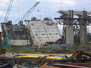
Collapse of Cần Thơ Bridge
2007 construction accident in Vietnam
Distance: Approx. 3649 meters
Latitude and longitude: 10.03777778,105.81638889
The collapse of Cần Thơ Bridge was a severe construction accident in southern Vietnam in September 2007. A 90-metre (300 ft) section of an approach ramp fell more than 30 metres (98 ft), killing and injuring dozens of people. The number of casualties remains unclear.

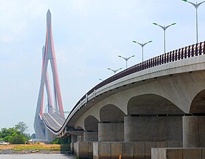
Cần Thơ Bridge
Bridge in Cần Thơ and Vĩnh Long, Vietnam
Distance: Approx. 2773 meters
Latitude and longitude: 10.03165278,105.80863889
Cần Thơ Bridge (Vietnamese: Cầu Cần Thơ), is a cable-stayed bridge over the Hậu (Bassac) River, the largest distributary of the Mekong River, in the city of Cần Thơ in southern Vietnam. The bridge is 2.75 kilometres long (1.68 miles). It has a 6-lane carriageway measuring 23 metres (76 feet) in width, with 4 lanes for automobile traffic and two lanes for bicycles and motorbikes.

Cù Lao Dung district
District in Mekong Delta, Vietnam
Distance: Approx. 669 meters
Latitude and longitude: 10.03916667,105.78166667
Cù Lao Dung is a rural district (huyện) of Sóc Trăng province in the Mekong River Delta region of Vietnam. As of 2003 the district had a population of 62,025. The district covers an area of 235 km2.
Mỹ Tú district
District in Mekong Delta, Vietnam
Distance: Approx. 669 meters
Latitude and longitude: 10.03916667,105.78166667
Mỹ Tú is a rural district (huyện) of Sóc Trăng province in the Mekong River Delta region of Vietnam. As of 2003 the district had a population of 207,634. The district covers an area of 588 km².
Thạnh Trị district
District in Mekong Delta, Vietnam
Distance: Approx. 669 meters
Latitude and longitude: 10.03916667,105.78166667
Thạnh Trị is a district (huyện) of Sóc Trăng province in the Mekong River Delta region of Vietnam. As of 2003 the district had a population of 86,262. The district covers an area of 281 km².

Cần Thơ Museum
Distance: Approx. 414 meters
Latitude and longitude: 10.0352,105.7867
Can Tho Museum is a museum in Cần Thơ, Vietnam. Situated on the corner of Hoa Binh and Tran Quoc Toan streets it was established in 1976 and has more than 5000 objects and historical relics. The museum acknowledges earlier settlement by the Khmer people as well as the contributions of the Chinese Ming refugees and later arrivals.
Cần Thơ Stadium
Distance: Approx. 1826 meters
Latitude and longitude: 10.04888889,105.78888889
Cần Thơ Stadium (Vietnamese: Sân vận động Cần Thơ) is a multi-use stadium located in Ninh Kiều District, Cần Thơ, Vietnam. Holding over 30,000 people, Cần Thơ is the largest stadium in the country. The stadium is mostly used for football matches and motorcycle racing.
Weather in this IP's area
overcast clouds
24 Celsius
25 Celsius
24 Celsius
24 Celsius
1013 hPa
100 %
1013 hPa
1012 hPa
8000 meters
1.03 m/s
100 %
