Country:
 South Korea
Region:
City:
Latitude and Longitude:
Time Zone:
Postal Code:
IP information under different IP Channel
ip-api
Country
Region
City
ASN
Time Zone
ISP
Blacklist
Proxy
Latitude
Longitude
Postal
Route
IPinfo
Country
Region
City
ASN
Time Zone
ISP
Blacklist
Proxy
Latitude
Longitude
Postal
Route
MaxMind
Country
Region
City
ASN
Time Zone
ISP
Blacklist
Proxy
Latitude
Longitude
Postal
Route
Luminati
Country
KRRegion
11
City
yangcheongu
ASN
Time Zone
Asia/Seoul
ISP
MOACK.Co.LTD
Latitude
Longitude
Postal
db-ip
Country
Region
City
ASN
Time Zone
ISP
Blacklist
Proxy
Latitude
Longitude
Postal
Route
ipdata
Country
Region
City
ASN
Time Zone
ISP
Blacklist
Proxy
Latitude
Longitude
Postal
Route
Popular places and events near this IP address

Yongsan District
Autonomous District in Sudogwon, South Korea
Distance: Approx. 395 meters
Latitude and longitude: 37.53833333,126.96555556
Yongsan District (Korean: 용산구; RR: Yongsan-gu, [jo̞ŋsʰa̠n ku]) is one of the 25 districts of Seoul, South Korea. Yongsan has a population of 231,685 (2020) and has a geographic area of 21.87 km2 (8.44 sq mi), and is divided into 19 dong (administrative neighborhoods). Yongsan is located near Downtown Seoul, on the northern bank of the Han River, bordering the city districts of Jung to the north, Mapo to the west, Yeongdeungpo and Dongjak to the southwest, Seocho and Gangnam District to the southeast, and Seongdong to the east.
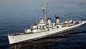
USS Erben
Fletcher-class destroyer
Distance: Approx. 745 meters
Latitude and longitude: 37.5364833,126.9782484
USS Erben (DD-631), a Fletcher-class destroyer, was a ship of the United States Navy named for Rear Admiral Henry Erben (1832–1909). Erben (DD-631) was launched 21 March 1943 by Bath Iron Works Corp., Bath, Maine; sponsored by Mrs. C. B. G. Gaillard, daughter of Rear Admiral Erben; and commissioned 28 May 1943.

War Memorial of Korea
Military museum in Seoul, South Korea
Distance: Approx. 646 meters
Latitude and longitude: 37.5365,126.9771
The War Memorial of Korea (Korean: 전쟁기념관) is a museum located in Yongsan-dong, Yongsan-gu, Seoul, South Korea. It opened in 1994 on the former site of the army headquarters to exhibit and memorialize the military history of Korea. It was built for the purpose of preventing war through lessons from the Korean War and for the hoped for peaceful reunification of North and South Korea.

Statue of Brothers
War memorial in Seoul, South Korea
Distance: Approx. 627 meters
Latitude and longitude: 37.535093,126.976157
The Statue of Brothers (Korean: 형제의 상; RR: Hyeongje-ui sang) is a symbol of the Korean War at the War Memorial of Korea in Seoul. Its English text reads as follows : "The Statue of Brothers is an 18 meter wide and 11-meter high symbol of the Korean War. It consists of the upper part, lower part and inner part.

Namyeong station
Metro station on Seoul Subway Line 1
Distance: Approx. 320 meters
Latitude and longitude: 37.54055556,126.97138889
Namyeong station is a ground-level metro station on Seoul Subway Line 1 in Galwol Dong, Yongsan-gu, Seoul, South Korea. Subways of Line 1 move on Gyeongbu Line from this station. The station's sole exit offers access to a range of schools and Yongsan Railway Office.

Samgakji station
Train station in South Korea
Distance: Approx. 437 meters
Latitude and longitude: 37.53551,126.97393
Samgakji Station is a subway station on the Line 4 and Line 6 of the Seoul Metropolitan Subway. The Seoul War Memorial is a short walk away from exits 11 and 12. This station is on the west end of the Yongsan Garrison, which is a short walk from exit 13.

Hyochang Park station
Train station in South Korea
Distance: Approx. 773 meters
Latitude and longitude: 37.53916667,126.96138889
Hyochang Park Station is a subway station on Seoul Subway Line 6 and the Gyeongui–Jungang Line. It is named after Hyochang Park. Nearby is the Hyochang Stadium, a small field capable of hosting sports events.

Sookmyung Women's University station
Station of the Seoul Metropolitan Subway
Distance: Approx. 765 meters
Latitude and longitude: 37.54456,126.97213
Sookmyung Women's University Station is subway station 427, on the Seoul Subway Line 4 in Yongsan-gu, Seoul. It is also called Garwol station (갈월역). It is located in front of the main entrance of the Sookmyung Women's University.

Cheongpa-dong
Place in South Korea
Distance: Approx. 790 meters
Latitude and longitude: 37.545,126.97
Cheongpa-dong is a dong (neighborhood) of Yongsan District, Seoul, South Korea.

Wonhyoro-dong
Place in South Korea
Distance: Approx. 587 meters
Latitude and longitude: 37.53333333,126.96666667
Wonhyoro-dong is a dong, neighbourhood of Yongsan-gu in Seoul, South Korea.

Sunrin Internet High School
Public high school in Seoul, South Korea
Distance: Approx. 603 meters
Latitude and longitude: 37.5425,126.96638889
Sunrin Internet High School is an information technology-oriented vocational school in Seoul, South Korea.
Camp Kim
Military facility adjacent to Yongson Garrison, Seoul, South Korea
Distance: Approx. 357 meters
Latitude and longitude: 37.54,126.97305556
Camp Kim is a military facility located adjacent to Yongsan Garrison in Seoul, South Korea. Camp Kim is home to a USO facility, an Army and Air Force Exchange Service (AAFES) distribution and storage facility, an AAFES vehicle repair facility, the Special Operations Command Korea, and the Yongsan Garrison office for vehicle registration and decals. The USO facility consists of a canteen, tour and ticket office, the Virtues Development Program, the Good Neighbor Program, a big screen television lounge.
Weather in this IP's area
broken clouds
20 Celsius
20 Celsius
18 Celsius
22 Celsius
1018 hPa
73 %
1018 hPa
1016 hPa
10000 meters
5.66 m/s
340 degree
75 %
06:43:48
17:50:03