115.72.160.132 - IP Lookup: Free IP Address Lookup, Postal Code Lookup, IP Location Lookup, IP ASN, Public IP
Country:
Region:
City:
Location:
Time Zone:
Postal Code:
ISP:
ASN:
language:
User-Agent:
Proxy IP:
Blacklist:
IP information under different IP Channel
ip-api
Country
Region
City
ASN
Time Zone
ISP
Blacklist
Proxy
Latitude
Longitude
Postal
Route
db-ip
Country
Region
City
ASN
Time Zone
ISP
Blacklist
Proxy
Latitude
Longitude
Postal
Route
IPinfo
Country
Region
City
ASN
Time Zone
ISP
Blacklist
Proxy
Latitude
Longitude
Postal
Route
IP2Location
115.72.160.132Country
Region
ba ria - vung tau
City
ben dinh
Time Zone
Asia/Ho_Chi_Minh
ISP
Language
User-Agent
Latitude
Longitude
Postal
ipdata
Country
Region
City
ASN
Time Zone
ISP
Blacklist
Proxy
Latitude
Longitude
Postal
Route
Popular places and events near this IP address
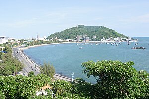
Vũng Tàu
Provincial city in Bà Rịa–Vũng Tàu province, Vietnam
Distance: Approx. 4054 meters
Latitude and longitude: 10.38333333,107.11666667
Vũng Tàu (Hanoi accent: [vuŋm˧ˀ˥ taːw˨˩] , Saigon accent: [vuŋm˧˩˧ taːw˨˩] ) is the largest city of Bà Rịa–Vũng Tàu province in southern Vietnam. It is the province's economic, financial and cultural centre, and a popular tourist hub in southern Vietnam. The city area is 141.1 square kilometres (54.5 square miles), consists of 16 urban wards and one commune of Long Sơn Island.
Vung Tau Airport
Airport in Vietnam
Distance: Approx. 1161 meters
Latitude and longitude: 10.37027778,107.09333333
Vung Tau Airport (IATA: VTG, ICAO: VVVT) is a small airport in southern Vietnam, in the Bà Rịa–Vũng Tàu province. It serves the city of Vũng Tàu and is located near the downtown of the city.

Christ of Vũng Tàu
Distance: Approx. 4677 meters
Latitude and longitude: 10.3264,107.084
Christ the King, of Vũng Tàu (Vietnamese: Tượng Chúa Kitô Vua, lit. 'Statue of Christ the King') is a statue of Jesus, standing on Mount Nhỏ in Vũng Tàu, Bà Rịa–Vũng Tàu province, Đông Nam Bộ, Vietnam. The Vietnamese Catholic Church built the statue in 1974 and it was completed on 2 December 1994 It is 32 metres (105 ft) high, standing on a 4 metres (13 ft) high platform, for a 36 metres (118 ft) total monument height with two outstretched arms spanning 18.3 metres (60 ft). There is a 133-step staircase inside the statue.
Vũng Tàu Port
Port in Vietnam
Distance: Approx. 1973 meters
Latitude and longitude: 10.386,107.085
Vung Tau Port is a group of seaports, one of the sea transport hubs of Vietnam. Vung Tau Port is located in Bà Rịa–Vũng Tàu province, Southeast region, Vietnam. Vung Tau port includes the following component ports: Cai Mep - Thi Vai Port, Sao Mai-Ben Dinh: This is the main port for container transport.

Hòn Bà
Islet in Vietnam
Distance: Approx. 5002 meters
Latitude and longitude: 10.32388889,107.08916667
Hòn Bà is an islet in the Bà Rịa–Vũng Tàu province of Vietnam. The islet is known for its temple.

Lê Quý Đôn High School for the Gifted, Vũng Tàu
Public school in Vung Tau, Ba Ria-Vung Tau, Vietnam
Distance: Approx. 6118 meters
Latitude and longitude: 10.3904,107.1341
Le Quy Don High School for the Gifted (Vietnamese: Trường Trung học phổ thông chuyên Lê Quý Đôn) is a designated high school for the gifted in Vung Tau, Vietnam. Established on 19 August 1991, the school is specialized for gifted students who possess interest and talent in the Natural Sciences, Social Sciences, or Foreign Language. The school is the only gifted high school in Ba Ria - Vung Tau.
Ward 1, Vũng Tàu
Ward in Vũng Tàu, Bà Rịa-Vũng Tàu, Vietnam
Distance: Approx. 3985 meters
Latitude and longitude: 10.4,107.1
Ward 1 (Phường 1) is a ward of Vũng Tàu in Bà Rịa–Vũng Tàu province, Vietnam, forming the historical centre of the city. The iconic Front Beach and Front Beach parklands as well as the former Vung Tau Market are located in this ward.
Ward 2, Vũng Tàu
Ward in Bà Rịa–Vũng Tàu, Vietnam
Distance: Approx. 4126 meters
Latitude and longitude: 10.33138889,107.08083056
Ward 2 (Phường 2) is a ward of Vũng Tàu in Bà Rịa–Vũng Tàu province, Vietnam.
Ward 3, Vũng Tàu
Ward in Bà Rịa–Vũng Tàu, Vietnam
Distance: Approx. 2330 meters
Latitude and longitude: 10.3475,107.08169444
Ward 3 (Phường 3) is a ward of Vũng Tàu in Bà Rịa–Vũng Tàu province, Vietnam.
Ward 5, Vũng Tàu
Ward in Bà Rịa–Vũng Tàu, Vietnam
Distance: Approx. 2179 meters
Latitude and longitude: 10.37194444,107.06333333
Ward 5 (Phường 5) is a ward of Vũng Tàu in Bà Rịa–Vũng Tàu province, Vietnam.
Ward 9, Vũng Tàu
Ward in Bà Rịa–Vũng Tàu, Vietnam
Distance: Approx. 1199 meters
Latitude and longitude: 10.3766,107.09
Ward 9 (Phường 9) is a ward of Vũng Tàu in Bà Rịa–Vũng Tàu province, Vietnam.
Thắng Nhì
Ward in Bà Rịa–Vũng Tàu, Vietnam
Distance: Approx. 199 meters
Latitude and longitude: 10.36666667,107.08333333
Thắng Nhì is a ward (phường) of Vũng Tàu in Bà Rịa–Vũng Tàu province, Vietnam.
Weather in this IP's area
overcast clouds
25 Celsius
25 Celsius
25 Celsius
25 Celsius
1012 hPa
71 %
1012 hPa
1011 hPa
10000 meters
2.95 m/s
3.41 m/s
64 degree
95 %
