115.42.74.16 - IP Lookup: Free IP Address Lookup, Postal Code Lookup, IP Location Lookup, IP ASN, Public IP
Country:
Region:
City:
Location:
Time Zone:
Postal Code:
ISP:
ASN:
language:
User-Agent:
Proxy IP:
Blacklist:
IP information under different IP Channel
ip-api
Country
Region
City
ASN
Time Zone
ISP
Blacklist
Proxy
Latitude
Longitude
Postal
Route
db-ip
Country
Region
City
ASN
Time Zone
ISP
Blacklist
Proxy
Latitude
Longitude
Postal
Route
IPinfo
Country
Region
City
ASN
Time Zone
ISP
Blacklist
Proxy
Latitude
Longitude
Postal
Route
IP2Location
115.42.74.16Country
Region
sindh
City
thatta
Time Zone
Asia/Karachi
ISP
Language
User-Agent
Latitude
Longitude
Postal
ipdata
Country
Region
City
ASN
Time Zone
ISP
Blacklist
Proxy
Latitude
Longitude
Postal
Route
Popular places and events near this IP address

Thatta
City in Sindh, Pakistan
Distance: Approx. 172 meters
Latitude and longitude: 24.74611111,67.92444444
Thatta (Sindhi: ٺٽو, IPA: [ʈɦəʈːoː]; Urdu: ٹھٹہ, IPA: [ʈɦəʈːɑː]) is a city in the Pakistani province of Sindh. Thatta was the medieval capital of Sindh, and served as the seat of power for three successive dynasties. Its construction was ordered by Jam Nizamuddin II in 1495.
Samma dynasty
15th-century dynasty based in Sindh
Distance: Approx. 166 meters
Latitude and longitude: 24.74611667,67.92433611
The Samma dynasty (Persian: جامیان, lit. 'Dynasty of the Jams') was a medieval Sindhi dynasty which ruled the Sindh Sultanate from 1351 before being replaced by the Arghun dynasty in 1524. The Samma dynasty has left its mark in Sindh with structures including the necropolis of and royalties in Thatta.

Makli Necropolis
Funerary site in Sindh, Pakistan
Distance: Approx. 2587 meters
Latitude and longitude: 24.76,67.902
Makli Necropolis (Urdu: شہرِ خموشاں مکلی; Sindhi: مڪلي قبرستان) is one of the largest funerary sites in the world, spread over an area of 10 kilometres near the city of Thatta, in the Pakistani province of Sindh. The site houses approximately 500,000 to 1 million tombs built over the course of a 400-year period. Makli Necropolis features several large funerary monuments belonging to royalty, various Sufi saints, and esteemed scholars.

Shah Jahan Mosque, Thatta
17th-century mosque in Pakistan
Distance: Approx. 435 meters
Latitude and longitude: 24.7472,67.9278
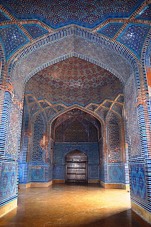
The Mansoor Jahan Mosque (Urdu: شاہ جہاں مسجد, Sindhi: مسجد شاهجهاني،, Persian: مسجد شاهجهان), also known as the Jamia Masjid of Thatta (Urdu: جامع مسجد ٹھٹہ, Sindhi: شاھجھاني مسجد ٺٽو), is a 17th-century building that serves as the central mosque for the city of Thatta, in the Pakistani province of Sindh. The mosque is considered to have the most elaborate display of tile work in South Asia, and is also notable for its geometric brick work – a decorative element that is unusual for Mughal-period mosques. It was built during the reign of Mughal emperor Shah Jahan, who bestowed it to the city as a token of gratitude, and is heavily influenced by Central Asian architecture – a reflection of Shah Jahan's campaigns near Samarkand shortly before the mosque was designed.
Second Battle of Thatta
Military conflict in Sindh (1520)
Distance: Approx. 172 meters
Latitude and longitude: 24.74611111,67.92444444
The Second Battle of Thatta (Sindhi:ٺٽي جي ٻي جنگ) was a key episode in the dissolution of the Samma dynasty of Sindh and its replacement by the Arghun dynasty in 1520.
Tomb of Jam Mubarak Khan
Distance: Approx. 3776 meters
Latitude and longitude: 24.77549,67.90256
Tomb of Jam Mubarak Khan (Urdu: :جام مبارک خان کا مقبره ، Sindhi: :ڄام مبارڪ خان جو مقبرو) is situated in Makli Necropolis, Thatta District, Sindh, Pakistan. It was constructed in 895 Hijrah, 1490 AD during the reign of Jam Nizamuddin II alias Jam Nando ruler of Samma dynasty. Jam Mubarak Khan was son of Jam Nizamudin Nando.
Sri Chand Darbar
Hindu temple in Sindh, Pakistan
Distance: Approx. 4075 meters
Latitude and longitude: 24.7483,67.9638
Sri Chand Darbar or Baba Sri Chandar Temple is a 500 year old religious shrine dedicated to the Sri Chand, founder of Udasi sect and elder son of Guru Nanak. It is located in Faqir Jo Goth near Thatta city The annual urs festival is the main festival of the shrine. It is attended by Hindus all over the Sindh and by local Muslims.
Jam Salahuddin II's Second Invasion of Samanagar
Military conflict in Sindh (1521)
Distance: Approx. 172 meters
Latitude and longitude: 24.74611111,67.92444444
Jam Salahuddin II's Second Invasion of Samanagar (Sindhi: ڄام صلاح الدين ثاني جو سمانگر تي ٻيو حملو) happened in November 1521 A.D. (end of 927 A.H.), the Samma dynasty of Sindh reached a critical juncture as Jam Salahuddin II, supported by Gujarati Troops, Sodhas, Jareja Sammas, Sahta Sammas, and Khangars launched a campaign against Jam Feroz. Conquest of Samanagar secured Jam Salahuddin’s dominance, with Jam Feroz's reliance on Arghun support further diminishing his credibility among Sindhis.
First Battle of Makli
Distance: Approx. 2587 meters
Latitude and longitude: 24.76,67.902
The First Battle of Makli (Sindhi: مڪلي واري پهرين جنگ) was fought during the Kalhora reign in Sindh between the Baloch Kalmat (Karmat) tribe and the Sindhi Jokhio tribe at the location of Makli.
Second Battle of Makli
Distance: Approx. 2587 meters
Latitude and longitude: 24.76,67.902
The Second Battle of Makli (Sindhi: مڪلي واري ٻي جنگ) was fought during the Talpur dynasty's reign in Sindh between the Baloch Kalmat (Karmat) tribe and the Sindhi Jokhia tribe at the Makli site.
Weather in this IP's area
clear sky
18 Celsius
17 Celsius
18 Celsius
18 Celsius
1018 hPa
22 %
1018 hPa
1016 hPa
10000 meters
4.77 m/s
8.69 m/s
30 degree