115.42.70.41 - IP Lookup: Free IP Address Lookup, Postal Code Lookup, IP Location Lookup, IP ASN, Public IP
Country:
Region:
City:
Location:
Time Zone:
Postal Code:
ISP:
ASN:
language:
User-Agent:
Proxy IP:
Blacklist:
IP information under different IP Channel
ip-api
Country
Region
City
ASN
Time Zone
ISP
Blacklist
Proxy
Latitude
Longitude
Postal
Route
db-ip
Country
Region
City
ASN
Time Zone
ISP
Blacklist
Proxy
Latitude
Longitude
Postal
Route
IPinfo
Country
Region
City
ASN
Time Zone
ISP
Blacklist
Proxy
Latitude
Longitude
Postal
Route
IP2Location
115.42.70.41Country
Region
punjab
City
bahawalpur
Time Zone
Asia/Karachi
ISP
Language
User-Agent
Latitude
Longitude
Postal
ipdata
Country
Region
City
ASN
Time Zone
ISP
Blacklist
Proxy
Latitude
Longitude
Postal
Route
Popular places and events near this IP address

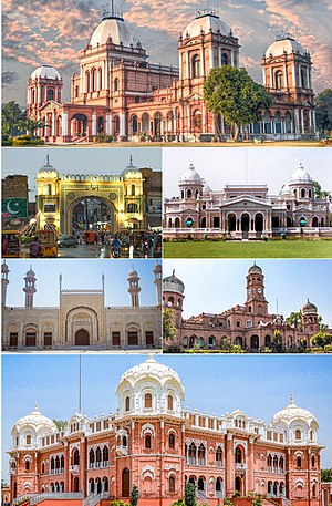
Bahawalpur
City in Punjab, Pakistan
Distance: Approx. 496 meters
Latitude and longitude: 29.39555556,71.68361111
Bahawalpur (Urdu: بہاول پور; Urdu pronunciation: [bəɦɑːwəlˈpuːɾ]) is a city in Punjab, Pakistan. It is the 13th largest city of Pakistan and 8th most populous city of Punjab. Bahawalpur is the capital of Bahawalpur Division.

Bahawal Stadium
Multi-purpose stadium in Bahawalpur, Pakistan
Distance: Approx. 477 meters
Latitude and longitude: 29.40416667,71.68444444
The Bahawal Stadium is a cricket ground in Bahawalpur, Punjab, Pakistan. Locally known as Dring Stadium, it is a multi-purpose stadium used mostly for staging cricket games. Situated on Stadium Road, opposite Bahawalpur Zoo, the stadium can accommodate 15,000 spectators.
Quaid-e-Azam Medical College
Medical college in Bahawalpur, Pakistan
Distance: Approx. 1398 meters
Latitude and longitude: 29.38861111,71.67722222
Quaid e Azam Medical College (Urdu: عظیم رہنما طبی دبستان, or QAMC) is a medical college in Bahawalpur, Pakistan.
Bahawalpur Zoo
Zoo in Punjab, Pakistan
Distance: Approx. 349 meters
Latitude and longitude: 29.402764,71.681601
Bahawalpur Zoo (Urdu: بہاولپور چڑیاگھر), established in 1942, is a 25-acre (10 ha) zoological garden in Bahawalpur, Punjab, Pakistan. It is managed by the Government of Pakistan. The zoo has occasionally bred and supplied wild cats, such as Asiatic lions and Bengal tigers, to other zoos in the country.
Bahawal Victoria Hospital
Hospital in Punjab, Pakistan
Distance: Approx. 1199 meters
Latitude and longitude: 29.38944444,71.68083333
Bahawal Victoria Hospital (Urdu: بہاول وکٹوریہ سپتال, abbreviated as BVH) is a hospital located in Bahawalpur, Pakistan. It is named after Nawab of Bahawalpur's British wife, Victoria.

Bahawalpur Museum
Distance: Approx. 1136 meters
Latitude and longitude: 29.38998824,71.68556437
The Bahawalpur Museum (Urdu: بہاولپور عجائب گھر), established in 1976, is a museum of archaeology, art, heritage, modern history and religion located in Bahawalpur, Punjab, Pakistan. It comes under the control of Bahawalpur district government. As of July 2022, the director of the museum is Muhammad Zubair Rabbani.

Fareed Gate
One of the historic gates of the Old City of Bahawalpur, Pakistan
Distance: Approx. 477 meters
Latitude and longitude: 29.395716,71.683302
Fareed Gate (Urdu: باب فريد), also spelled as Farid Gate, is a historical gate of the old city of Bahawalpur, Pakistan.

Bahawalpur Central Library
Pakistani library
Distance: Approx. 1013 meters
Latitude and longitude: 29.391016,71.684933
The Bahawalpur Central Library (Urdu: سنٹرل لائبریری بھاولپور), also known as Sadiq Reading Library, is a library in Bahawalpur, Punjab, Pakistan. It was founded on 8 March 1924 by Sir Rufus Daniel Issacs during the coronation year of Sadeq Mohammad Khan V. It cost 100,000 rupees by Bahawalpur State and is the second largest library in the province of Punjab.
Bahawalpur church shooting
Church massacre
Distance: Approx. 2322 meters
Latitude and longitude: 29.38997778,71.66230556
The Bahawalpur church shooting was a mass shooting at Saint Dominic's Church in Bahawalpur, Punjab, Pakistan on 28 October 2001 by six assailants belonging to Lashkar-e-Jhangvi. The guard of the church and 17 other Christians were killed.

Darbar Mahal
Building in Bahawalpur, Pakistan
Distance: Approx. 1630 meters
Latitude and longitude: 29.3972,71.6998
Darbar Mahal is a palace in Bahawalpur, Pakistan. The building was built to hold courtly events and government offices of the former princely state of Bahawalpur. The palace sits in a 75-acre (30 ha) garden.
Sadiq Dane High School
Public school in Pakistan
Distance: Approx. 666 meters
Latitude and longitude: 29.394184,71.684897
Government Sadiq Dane High School, also known as S. D. High School, is a high school located in Bahawalpur, Punjab, Pakistan. It is the largest school in Bahawalpur with over 2000 students currently enrolled. The building of the school is well known for its clocks.

Gulzar Mahal
Building in Bahawalpur, Pakistan
Distance: Approx. 1500 meters
Latitude and longitude: 29.3947,71.697514
Gulzar Mahal is a palace in the city of Bahawalpur, Pakistan. The palace has been leased by the armed forces since 1966, and is currently not open to the general public.
Weather in this IP's area
clear sky
21 Celsius
20 Celsius
21 Celsius
21 Celsius
1019 hPa
18 %
1019 hPa
1006 hPa
10000 meters
1.89 m/s
2.08 m/s
343 degree

