Country:
 Turkey
Region:
City:
Latitude and Longitude:
Time Zone:
Postal Code:
IP information under different IP Channel
ip-api
Country
Region
City
ASN
Time Zone
ISP
Blacklist
Proxy
Latitude
Longitude
Postal
Route
IPinfo
Country
Region
City
ASN
Time Zone
ISP
Blacklist
Proxy
Latitude
Longitude
Postal
Route
MaxMind
Country
Region
City
ASN
Time Zone
ISP
Blacklist
Proxy
Latitude
Longitude
Postal
Route
Luminati
Country
TRRegion
34
City
istanbul
ASN
Time Zone
Europe/Istanbul
ISP
HUAWEI CLOUDS
Latitude
Longitude
Postal
db-ip
Country
Region
City
ASN
Time Zone
ISP
Blacklist
Proxy
Latitude
Longitude
Postal
Route
ipdata
Country
Region
City
ASN
Time Zone
ISP
Blacklist
Proxy
Latitude
Longitude
Postal
Route
Popular places and events near this IP address
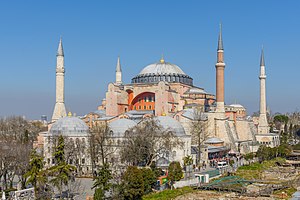
Hagia Sophia
Mosque and former church in Istanbul, Turkey
Distance: Approx. 144 meters
Latitude and longitude: 41.00833333,28.98
Hagia Sophia (Turkish: Ayasofya; Ancient Greek: Ἁγία Σοφία, romanized: Hagía Sophía; Latin: Sancta Sapientia; lit. 'Holy Wisdom'), officially the Hagia Sophia Grand Mosque (Turkish: Ayasofya-i Kebir Cami-i Şerifi), is a mosque and former church serving as a major cultural and historical site in Istanbul, Turkey. The last of three church buildings to be successively erected on the site by the Eastern Roman Empire, it was completed in AD 537. The site was a Greek Orthodox church from AD 360 to 1453, except for a brief time as a Latin Catholic church between the Fourth Crusade and 1261.

Basilica Cistern
Ancient cistern beneath Istanbul, Turkey
Distance: Approx. 47 meters
Latitude and longitude: 41.00805556,28.97777778
The Basilica Cistern, or Cisterna Basilica (Greek: Βασιλική Κινστέρνα, Turkish: Yerebatan Sarnıcı or Yerebatan Saray, "Subterranean Cistern" or "Subterranean Palace"), is the largest of several hundred ancient cisterns that lie beneath the city of Istanbul, Turkey. The cistern, located 150 metres (490 ft) southwest of the Hagia Sophia on the historical peninsula of Sarayburnu, was built in the 6th century during the reign of Byzantine emperor Justinian I. Today it is kept with little water, for public access inside the space.

Zeynep Sultan Mosque
Mosque in Istanbul, Turkey
Distance: Approx. 177 meters
Latitude and longitude: 41.0097,28.979
The Zeynep Sultan Mosque (in Turkish Zeynep Sultan Camii) is a mosque built in 1769 by Ayazma Mosque's architect Mehmet Tahir Ağa for Ahmed III's daughter Zeynep Sultan. It evokes Byzantine churches because of its architectural style and materials that were used in its construction.

Pudding Shop
Distance: Approx. 95 meters
Latitude and longitude: 41.00805,28.97719
The Pudding Shop is the nickname for the Lale Restaurant in Sultanahmet, Istanbul, Turkey. It became popular in the 1960s as a meeting place for beatniks and, later on, hippies and other travellers on overland route between Europe and India, Nepal, and elsewhere in Asia: the "hippie trail". The restaurant got its colloquial name as a result of "word of mouth" from numerous foreign travellers that could not remember the name of the restaurant but did remember the wide and popular selection of puddings sold there and thus referred to it as the "pudding shop".

Historic Areas of Istanbul
World Heritage Sites in Turkey
Distance: Approx. 140 meters
Latitude and longitude: 41.00846944,28.97993056
The Historic Areas of Istanbul are a group of sites in the capital district of Fatih in the city of Istanbul, Turkey. These areas were added to the UNESCO World Heritage List in 1985. This World Heritage Site includes buildings and structures such as the Sarayburnu, the Topkapı Palace, the Hagia Sophia, the Sultan Ahmed Mosque, the Hagia Irene, Zeyrek Mosque, Süleymaniye Mosque, Little Hagia Sophia and the Walls of Constantinople.

Caferağa Medrese
Former Ottoman school built by architect Mimar Sinan
Distance: Approx. 166 meters
Latitude and longitude: 41.00964,28.97883
The Caferağa Medrese or Cafer Ağa Madrasa (Turkish: Caferağa Medresesi) is a former medrese, located in Istanbul, Turkey, next to the Hagia Sophia. It was built in 1559 by Mimar Sinan on the orders of Cafer Agha, during the reign of Sultan Suleiman the Magnificent (1520–1566). The medrese was transformed by the Turkish Cultural Service Foundation in 1989 into a tourist centre with 15 classrooms/exhibition rooms, a big salon and a garden where traditional Turkish handicrafts such as calligraphy, ceramics, jewelry and so forth are taught, made and sold.
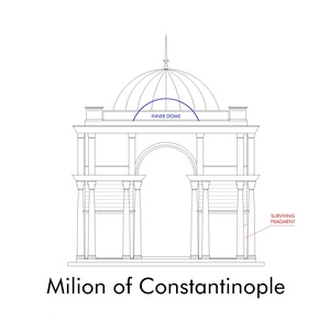
Milion
Byzantine mile-marker monument in Constantinople
Distance: Approx. 26 meters
Latitude and longitude: 41.00804167,28.97806667
The Milion (Greek: Μίλιον or Μίλλιον, Mílion; Turkish: Milyon taşı) was a marker from which all distances across the Roman Empire were measured. Erected by Septimus Severus in the 3rd century AD in the city of Byzantium, it became the zero-mile marker for the empire upon the re-founding of the city as Constantinople in 330 AD. Thereafter, it would serve as the starting-place for the measurement of distances for all the roads leading to the cities of the Eastern Roman Empire. It thus served the same function as the Golden Milestone (Milliarium Aureum) in Rome's forum, erected by Augustus.

Augustaion
Distance: Approx. 63 meters
Latitude and longitude: 41.008,28.979
The Augustaion (Greek: Αὐγουσταῖον) or, in Latin, Augustaeum, was an important ceremonial square in ancient and medieval Constantinople (modern Istanbul, Turkey), roughly corresponding to the modern Aya Sofya Meydanı (Turkish, "Hagia Sophia Square"). Originating as a public market, in the 6th century it was transformed into a closed courtyard surrounded by porticoes, and provided the linking space between some of the most important edifices in the Byzantine capital. The square survived until the late Byzantine period, albeit in ruins, and traces were still visible in the early 16th century.

Firuz Agha Mosque
Mosque in Istanbul, Turkey
Distance: Approx. 178 meters
Latitude and longitude: 41.007708,28.97629
The Firuz Ağa Mosque (Turkish: Firuz Ağa Camii) is a 15th-century Ottoman mosque in the Fatih district of Istanbul, Turkey. It was built by Firuz Ağa, the head treasurer of Sultan Beyazıt II. The marble sarcophagus of Firuz Ağa is located in the mosque complex. The mosque is located in the historical center of the city of Istanbul, on the Divanyolu Street, close to other prominent historical landmarks, Sultanahmet Mosque, Aya Sofya and Basilica Cistern.

Old Darülfünun building
University building, parliamentary building in Istanbul, Turkey
Distance: Approx. 180 meters
Latitude and longitude: 41.00728,28.98006
Old Darülfünun building (Turkish: Eski Darülfünun Binası) was a university building constructed next to Haghia Sophia in Istanbul, Ottoman Empire in the mid-19th century. It was a three-storey building in neo-Renaissance style that had a great visual impact on Istanbul's urban character. The building's designer was Swiss architect Gaspare Fossati (1809—1883), who was also responsible for extensive restoration of Hagia Sophia.
740 Constantinople earthquake
740 Earthquake in Constantinople
Distance: Approx. 8 meters
Latitude and longitude: 41.0082,28.9784
The 740 Constantinople earthquake took place on 26 October, 740, in the vicinity of Constantinople and the Sea of Marmara. In Constantinople, the earthquake caused the collapse of many public buildings. The Walls of Constantinople were also damaged.
447 Constantinople earthquake
Earthquake in present-day Turkey
Distance: Approx. 34 meters
Latitude and longitude: 41.008,28.978
The area around Constantinople was affected by a major earthquake in AD 447. It caused serious damage to the recently completed Theodosian Walls in Constantinople, destroying 57 towers and large stretches of the walls. The historical records contain no mention of casualties directly associated with this earthquake, although many thousands of people were reported to have died in the aftermath due to starvation and a "noxious smell".
Weather in this IP's area
thunderstorm
22 Celsius
23 Celsius
21 Celsius
23 Celsius
1015 hPa
81 %
1015 hPa
1011 hPa
10000 meters
3.6 m/s
10 degree
75 %
06:38:01
19:25:45