Country:
Region:
City:
Latitude and Longitude:
Time Zone:
Postal Code:
IP information under different IP Channel
ip-api
Country
Region
City
ASN
Time Zone
ISP
Blacklist
Proxy
Latitude
Longitude
Postal
Route
Luminati
Country
Region
38
City
matsuyama
ASN
Time Zone
Asia/Tokyo
ISP
STNet, Incorporated
Latitude
Longitude
Postal
IPinfo
Country
Region
City
ASN
Time Zone
ISP
Blacklist
Proxy
Latitude
Longitude
Postal
Route
db-ip
Country
Region
City
ASN
Time Zone
ISP
Blacklist
Proxy
Latitude
Longitude
Postal
Route
ipdata
Country
Region
City
ASN
Time Zone
ISP
Blacklist
Proxy
Latitude
Longitude
Postal
Route
Popular places and events near this IP address
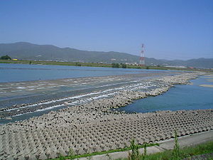
Yoshino River
River in Shikoku, Japan
Distance: Approx. 2201 meters
Latitude and longitude: 34.078499,134.600722
The Yoshino River (吉野川 Yoshino-gawa) is a river on the island of Shikoku, Japan. It is 194 km (121 mi) long and has a watershed of 3,750 km2 (1,450 sq mi). It is the second longest river in Shikoku (slightly shorter than the Shimanto), and is the only river whose watershed spreads over the four prefectures of the island.
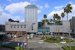
Tokushima Station
Railway station in Tokushima, Japan
Distance: Approx. 2478 meters
Latitude and longitude: 34.07444444,134.55111111
Tokushima Station (徳島駅, Tokushima-eki) is a junction passenger railway station located in the city of Tokushima in Tokushima Prefecture, Japan, operated by the Shikoku Railway Company (JR Shikoku).
Tokushima Domain
Feudal domain under the Tokugawa shogunate of Edo period Japan
Distance: Approx. 2105 meters
Latitude and longitude: 34.07519167,134.555275
Tokushima Domain (徳島藩, Tokushima-han) was a feudal domain under the Tokugawa shogunate of Edo period Japan, controlling all of Awa Province and Awaji Province in what is now Tokushima Prefecture and Awaji Island of modern-day Hyōgo Prefecture. It was centered around Tokushima Castle, and was ruled throughout its history by the tozama daimyō Hachisuka clan.

Joto High School
School in Tokushima, Tokushima, Japan
Distance: Approx. 1753 meters
Latitude and longitude: 34.0725,134.55888889
Tokushima Prefectural Joto High School (徳島県立城東高等学校, Tokushima Kenritsu Jōtō Kōtō Gakkō) is a secondary school in Tokushima, Tokushima, Japan, founded in 1902. It is one of the top high schools in Tokushima Prefecture. Approximately 1,100 students attend the school.
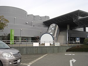
Asty Tokushima
Indoor arena and conference venue in Tokushima, Tokushima, Japan
Distance: Approx. 2531 meters
Latitude and longitude: 34.053147,134.563894
Asty Tokushima (アスティとくしま) or the Tokushima Industry and Tourism Exchange Center (徳島県立産業観光交流センター, Tokushima Kenritsu Sangyō Kankō Kōryū Sentā) is an indoor arena and conference venue in Tokushima, Tokushima, Japan. The arena opened in 1993. "ASTY" in the venue's name is an acronym which stands for "Attractive Space in Tokushima Yamashiro".

University of Tokushima
Higher education institution in Tokushima Prefecture, Japan
Distance: Approx. 1678 meters
Latitude and longitude: 34.07,134.56
Tokushima University (徳島大学, Tokushima Daigaku) is a national university in the city of Tokushima, Japan, with seven graduate schools and five undergraduate faculties. The university was founded in 1949 by merging six national education facilities into one. The 2014 Nobel Prize Laureate in Physics, Shuji Nakamura, graduated from Tokushima University.

Shinmachi River
River in Japan
Distance: Approx. 2621 meters
Latitude and longitude: 34.0525,134.5925
The Shinmachi River (新町川, Shinmachigawa) is a river found in the heart of Tokushima City in Tokushima Prefecture. The Suketō River, Tamiya River, Sako River, and Sumiyoshijima River are its tributaries. At current, the non-profit organization Shinmachi Preservation Committee is in charge of keeping the river clean and holding tours around the river via boat.

Suketō River
River in Tokushima City in Tokushima Prefecture, Japan
Distance: Approx. 1451 meters
Latitude and longitude: 34.066989,134.56375
The Suketō River (助任川, Suketō-gawa), also called the Fukushima River, is a river in Tokushima Prefecture, Japan.
Awa-Tomida Station
Railway station in Tokushima, Japan
Distance: Approx. 2261 meters
Latitude and longitude: 34.0639,134.5558
Awa-Tomida Station (阿波富田駅, Awa-Tomida-eki) is a passenger railway station located in the city of Tokushima, Tokushima Prefecture, Japan. It is operated by JR Shikoku and has the station number "M01".
Mikawa House
Distance: Approx. 2120 meters
Latitude and longitude: 34.0664,134.5562
Mikawa House (三河家住宅, Mikawa-ke jūtaku) is a historical building in Tokushima, Japan. It was designated an Important Cultural Property of Japan in 2007.

Tokushima Castle Museum
Building in Tokushima Prefecture, Japan
Distance: Approx. 2047 meters
Latitude and longitude: 34.073617,134.55573
Tokushima Castle Museum (徳島市立徳島城博物館, Tokushima shiritsu Tokushima-jō hakubutsukan) opened in Tokushima, Japan, in 1992. The museum is located in a garden with the ruins of Tokushima Castle, and features exhibits about the history of the castle.
Tokushima Castle
Distance: Approx. 2105 meters
Latitude and longitude: 34.07519167,134.555275
Tokushima Castle (徳島城, Tokushima-jō) was an Edo period Japanese castle located in the city of Tokushima, Tokushima Prefecture, Japan. Its ruins have been protected as a National Historic Site since 1957. Its Omotegoten Gardens are designated a national Place of Scenic Beauty.
Weather in this IP's area
broken clouds
12 Celsius
11 Celsius
12 Celsius
14 Celsius
1024 hPa
82 %
1024 hPa
1024 hPa
10000 meters
3.09 m/s
280 degree
75 %
06:29:35
17:01:44
