Country:
Region:
City:
Latitude and Longitude:
Time Zone:
Postal Code:
IP information under different IP Channel
ip-api
Country
Region
City
ASN
Time Zone
ISP
Blacklist
Proxy
Latitude
Longitude
Postal
Route
Luminati
Country
Region
37
City
sanbonmatsu
ASN
Time Zone
Asia/Tokyo
ISP
STNet, Incorporated
Latitude
Longitude
Postal
IPinfo
Country
Region
City
ASN
Time Zone
ISP
Blacklist
Proxy
Latitude
Longitude
Postal
Route
db-ip
Country
Region
City
ASN
Time Zone
ISP
Blacklist
Proxy
Latitude
Longitude
Postal
Route
ipdata
Country
Region
City
ASN
Time Zone
ISP
Blacklist
Proxy
Latitude
Longitude
Postal
Route
Popular places and events near this IP address
Higashikagawa, Kagawa
City in Shikoku, Japan
Distance: Approx. 3535 meters
Latitude and longitude: 34.25,134.36666667
Higashikagawa (東かがわ市, Higashikagawa-shi) is a city located in Kagawa Prefecture, Japan. As of 30 September 2022, the city had an estimated population of 28,627 in 13689 households and a population density of and a population density of 970 persons per km2. The total area of the city is 152.83 square kilometres (59.01 sq mi).

Battle of Hiketa
Distance: Approx. 7509 meters
Latitude and longitude: 34.23372,134.40835
The Siege of Hiketa (引田の戦い) was a battle during the Azuchi–Momoyama period (16th century) of Japan. The siege of Hiketa Castle was a certain battle that was fought by Sengoku Hidehisa against Chōsokabe Motochika. In the end however, Motochika won this victory.

Hiketa Station
Distance: Approx. 7192 meters
Latitude and longitude: 34.2237,134.4012
Hiketa Station (引田駅, Hiketa-eki) is a passenger railway station located in the city of Higashikagawa, Kagawa Prefecture, Japan. It is operated by JR Shikoku and has the station number "T10".

Sanuki-Shirotori Station
Passenger railway station in Higashikagawa, Kagawa Prefecture, Japan
Distance: Approx. 3451 meters
Latitude and longitude: 34.2433,134.3656
Sanuki-Shirotori Station (讃岐白鳥駅, Sanuki-Shirotori-eki) is a passenger railway station located in the city of Higashikagawa, Kagawa Prefecture, Japan. It is operated by JR Shikoku and has the station number "T11".
Sambommatsu Station (Kagawa)
Passenger railway station in Higashikagawa, Kagawa Prefecture, Japan
Distance: Approx. 746 meters
Latitude and longitude: 34.25166667,134.33444444
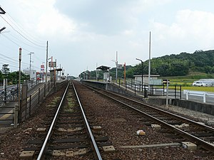
Sambommatsu Station (三本松駅, Sambommatsu-eki) is a passenger railway station located in the city of Higashikagawa, Kagawa Prefecture, Japan. It is operated by JR Shikoku and has the station number "T12".

Nibu Station
Passenger railway station in Higashikagawa, Kagawa Prefecture, Japan
Distance: Approx. 2616 meters
Latitude and longitude: 34.2548,134.3015
Nibu Station (丹生駅, Nibu-eki) is a passenger railway station located in the city of Higashikagawa, Kagawa Prefecture, Japan. It is operated by JR Shikoku and has the station number "T13".

Tsuruwa Station
Passenger railway station in Sanuki, Kagawa Prefecture, Japan
Distance: Approx. 6201 meters
Latitude and longitude: 34.2802,134.2741
Tsuruwa Station (鶴羽駅, Tsuruwa-eki) is a passenger railway station located in the city of Sanuki, Kagawa Prefecture, Japan. It is operated by JR Shikoku and has the station number "T14".

Hiketa Castle
Castle ruins in Kagawa, Japan
Distance: Approx. 7509 meters
Latitude and longitude: 34.23372,134.40835
Hiketa Castle (引田城, Hiketa-jō) was a Sengoku period Japanese castle located in what is now part of the city of Higashikagawa, Kagawa Prefecture, Japan. Its ruins have been protected by the central government as a National Historic Site since 2020.
Gomyo Dam
Dam in Kagawa Prefecture, Japan
Distance: Approx. 7423 meters
Latitude and longitude: 34.19805556,134.27388889
Gomyo Dam (Japanese: 五名ダム(再)) is a gravity dam located in Kagawa Prefecture in Japan. The dam is used for flood control and water supply. The catchment area of the dam is 10.4 km2.
Mikuro-ike Dam
Dam in Kagawa Prefecture, Japan
Distance: Approx. 7781 meters
Latitude and longitude: 34.25555556,134.24444444
Mikuro-ike (Japanese: 弥勒池) is an earthfill dam located in Kagawa Prefecture in Japan. The dam is used for irrigation. The dam impounds about 4 ha of land when full and can store 236 thousand cubic meters of water.
Ohuchi Dam (Kagawa, Japan)
Dam in Kagawa Prefecture, Japan
Distance: Approx. 3999 meters
Latitude and longitude: 34.22194444,134.2975
Ohuchi Dam (Japanese: 大内ダム) is a gravity dam located in Kagawa Prefecture in Japan. The dam is used for flood control and water supply. The catchment area of the dam is 3.2 km2.
Okawa Dam (Kagawa, Japan)
Dam in Kagawa Prefecture, Japan
Distance: Approx. 7496 meters
Latitude and longitude: 34.23611111,134.24805556
Okawa Dam (Japanese: 大川ダム) is a gravity dam located in Kagawa Prefecture in Japan. The dam is used for flood control. The catchment area of the dam is 4 km2.
Weather in this IP's area
overcast clouds
12 Celsius
11 Celsius
12 Celsius
12 Celsius
1024 hPa
64 %
1024 hPa
1023 hPa
10000 meters
1.22 m/s
2.04 m/s
93 degree
100 %
06:30:53
17:02:25

