115.188.25.98 - IP Lookup: Free IP Address Lookup, Postal Code Lookup, IP Location Lookup, IP ASN, Public IP
Country:
 New Zealand
Region:
City:
Location:
Time Zone:
Postal Code:
ISP:
ASN:
language:
User-Agent:
Proxy IP:
Blacklist:
IP information under different IP Channel
ip-api
Country
Region
City
ASN
Time Zone
ISP
Blacklist
Proxy
Latitude
Longitude
Postal
Route
db-ip
Country
Region
City
ASN
Time Zone
ISP
Blacklist
Proxy
Latitude
Longitude
Postal
Route
IPinfo
Country
Region
City
ASN
Time Zone
ISP
Blacklist
Proxy
Latitude
Longitude
Postal
Route
IP2Location
115.188.25.98Country
nzRegion
northland
City
kawakawa
Time Zone
Pacific/Auckland
ISP
Language
User-Agent
Latitude
Longitude
Postal
ipdata
Country
Region
City
ASN
Time Zone
ISP
Blacklist
Proxy
Latitude
Longitude
Postal
Route
Popular places and events near this IP address

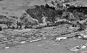
Kawakawa, New Zealand
Town in Northland, New Zealand
Distance: Approx. 418 meters
Latitude and longitude: -35.38,174.06888889
Kawakawa is a small town in the Bay of Islands area of the Northland Region of New Zealand. Kawakawa developed as a service town when coal was found there in the 1860s, but coal mining ceased in the early 20th century. The economy is now based on farming.

Moerewa
Place in Northland Region, New Zealand
Distance: Approx. 4273 meters
Latitude and longitude: -35.38583333,174.01972222
Moerewa is a small town in the Northland Region of the North Island of New Zealand. It is located close to the Bay of Islands five kilometres to the west of Kawakawa. Moerewa is a service town for the surrounding farming industry.

Opua Branch
Railway line in New Zealand
Distance: Approx. 3715 meters
Latitude and longitude: -35.36,174.096
The Opua Branch or Otiria-Opua Industrial Line, partially still operational as the Bay of Islands Vintage Railway, is a former section of the North Auckland Line in the Northland Region of New Zealand, between Otiria and the Bay of Islands township of Opua. The first section was constructed as a bush tramway in 1867 and converted to a railway in the next decade. Today the railway is partially used by the Bay of Islands Vintage Railway, which runs tourist services between Kawakawa and Te Akeake.

Taumarere
Place in Northland Region, New Zealand
Distance: Approx. 3354 meters
Latitude and longitude: -35.363,174.094
Taumarere is a locality in the Bay of Islands in Northland, New Zealand. The Kawakawa River and State Highway 11 run through Taumarere. The town of Kawakawa is 3 km to the southwest.
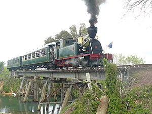
Bay of Islands Vintage Railway
Heritage railway in New Zealand
Distance: Approx. 400 meters
Latitude and longitude: -35.380175,174.064525
The Bay of Islands Vintage Railway Trust (BOIVRT) is a heritage railway in Kawakawa, in Northland, New Zealand. The railway operates on part of the former Opua Branch railway.
Bay of Islands County
Former county in New Zealand
Distance: Approx. 418 meters
Latitude and longitude: -35.38,174.06888889
Bay of Islands County was one of the counties of New Zealand in the North Island.

Hundertwasser Toilets
Public toilet in Kawakawa, New Zealand
Distance: Approx. 373 meters
Latitude and longitude: -35.37995556,174.06697778
The Hundertwasser Toilets is a public toilet located at 60 Gillies Street, the main street of the town of Kawakawa in northern New Zealand. The structure was completed in 1999 and named after the architect and visual artist Friedensreich Hundertwasser, who conceived and designed the project. It is one of the few toilet blocks worldwide seen both as an international work of art and a tourist attraction in its own right.

Te Akeake railway station
Defunct railway station in New Zealand
Distance: Approx. 5350 meters
Latitude and longitude: -35.3491,174.1081
Te Akeake railway station is a station on the Opua Branch in New Zealand. The station, sometimes named Teakeake, opened after an application for a stopping place, 1.5 mi (2.4 km) from Taumarere, was made on 7 July 1888. About 1898, after an "application from natives", on 28 December 1893, a shelter shed and platform were built.

Kawakawa railway station
Defunct railway station in New Zealand
Distance: Approx. 440 meters
Latitude and longitude: -35.3804,174.0634
Kawakawa railway station was a station on the Opua Branch in New Zealand. and is the terminus of the Bay of Islands Vintage Railway (BoIVR) in the small town of Kawakawa. It was also the terminus of the oldest railway on the North Island, opened in 1867, before being joined to the rest of the North Auckland Line in 1912.

Taumarere railway station
Defunct railway station in New Zealand
Distance: Approx. 3509 meters
Latitude and longitude: -35.3609,174.0939
Taumarere railway station was a station on the Opua Branch in New Zealand and is a stop on the Bay of Islands Vintage Railway near Taumarere village. It is on the oldest railway built on the North Island, which opened in 1867. Taumarere station has had three locations, east of the village, west of the village and at the rugby ground.
Moerewa railway station
Defunct railway station in New Zealand
Distance: Approx. 3879 meters
Latitude and longitude: -35.387,174.0242
Moerewa railway station was a flag station at Moerewa on the Opua Branch of the North Auckland Line in New Zealand. The portion of the Opua–Grahamtown Line from Kawakawa to what was then called Scoria Flat was finished about 1905. In May 1908 it was noted that trains ran to Scoria Flat about once a week, as there were no houses and "what little traffic arises is almost solely from villages further inland." By 1909 plans were being made for stockyards and a gravel pit, but on 23 December 1910 the Minister of Public Works decided to abandon the station at Scoria Flat and move the shelter shed, platform, goods shed, loading bank, small stockyards, 2 x 400 gallon tanks and sidings to Otiria Junction, "as the site was found unsuitable for the junction of the Kaikohe Branch." Bay of Islands County Council and others asked for the station to be reinstated, but that didn't happen until the Kauri Timber Company negotiated for a site for a sawmill.
Karetu River (Northland)
River in Northland Region, New Zealand
Distance: Approx. 5381 meters
Latitude and longitude: -35.35527778,174.115
The Karetu River is located in the Northland Region of New Zealand, approximately 47 kilometres (29 mi) north of Whangārei. Its source is on the north-western slopes of the 407-metre (1,335 ft) hill Te Rangi in the Russell Forest. The river begins as two streams, Whakatane Stream and Karetu Stream, which join and flow down the Whaakaurau Valley through the settlement of Karetu.
Weather in this IP's area
scattered clouds
21 Celsius
22 Celsius
21 Celsius
21 Celsius
1018 hPa
77 %
1018 hPa
1004 hPa
10000 meters
0.41 m/s
1.93 m/s
94 degree
46 %