Country:
Region:
City:
Latitude and Longitude:
Time Zone:
Postal Code:
IP information under different IP Channel
ip-api
Country
Region
City
ASN
Time Zone
ISP
Blacklist
Proxy
Latitude
Longitude
Postal
Route
Luminati
Country
ASN
Time Zone
Asia/Bangkok
ISP
SBN-ISPAWN-ISP and SBN-NIXAWN-NIX
Latitude
Longitude
Postal
IPinfo
Country
Region
City
ASN
Time Zone
ISP
Blacklist
Proxy
Latitude
Longitude
Postal
Route
db-ip
Country
Region
City
ASN
Time Zone
ISP
Blacklist
Proxy
Latitude
Longitude
Postal
Route
ipdata
Country
Region
City
ASN
Time Zone
ISP
Blacklist
Proxy
Latitude
Longitude
Postal
Route
Popular places and events near this IP address

Saphan Khwai
Road junction
Distance: Approx. 987 meters
Latitude and longitude: 13.78977778,100.54800278
Saphan Khwai (Thai: สะพานควาย, pronounced [sā.pʰāːn kʰwāːj]) is intersection and neighbourhood on overlapped area of Phaya Thai and Sam Sen Nai Subdistricts, Phaya Thai District, Bangkok, Thailand. The surrounding neighbourhood is studded with many apartments and is best known for its many shops and markets. It is served by the BTS skytrain service at Saphan Khwai Station.

Din Daeng district
District in Bangkok, Thailand
Distance: Approx. 1548 meters
Latitude and longitude: 13.76972222,100.55277778
Din Daeng (Thai: ดินแดง, pronounced [dīn dɛ̄ːŋ]) is one of the 50 districts (khet) of Bangkok, Thailand. Its neighbours, clockwise from north, are Chatuchak, Huai Khwang, Ratchathewi, and Phaya Thai.

Royal Thai Army Stadium
Multi-purpose football stadium in Bangkok, Thailand
Distance: Approx. 1217 meters
Latitude and longitude: 13.782661,100.556185
The Royal Thai Army Stadium (Thai: สนามกีฬากองทัพบก) is a multi-purpose stadium on Vibhavadi Rangsit Road in the Phaya Thai of north Bangkok, Thailand. It is currently used mostly for football matches. The stadium holds 20,000 and has a single stand with covered seating on one side and terracing on three sides.
National Defence College of Thailand
Distance: Approx. 1327 meters
Latitude and longitude: 13.779832,100.557165
The National Defence College of Thailand or NDC (Thai: วิทยาลัยป้องกันราชอาณาจักร; RTGS: Witthayalai Pongkan Ratcha-anachak) is an education organization that provides advanced training for both senior military officers and civilians. It is operated by the Royal Thai Armed Forces Headquarters of the Ministry of Defence.

Sam Sen Nai Philatelic Museum
Distance: Approx. 1443 meters
Latitude and longitude: 13.7938,100.5489
Thai Philatelic Museum (Thai: พิพิธภัณฑ์ตราไปรษณียากร) is a postal museum in Phaya Thai District in Bangkok, Thailand. It was renovated and moved to the building behind the Samsen Nai post office at Saphan Khwai in December 2004. Among its exhibits are the awards Thai philatelists received from various international competitions together with photocopies of the winning entries, posters depicting rare Thai stamps, and winning postage stamp designs.
Saphan Khwai BTS station
Railway station in Bangkok, Thailand
Distance: Approx. 1472 meters
Latitude and longitude: 13.7938,100.54973056
Saphan Khwai station (Thai: สถานีสะพานควาย, pronounced [sā.tʰǎː.nīː sā.pʰāːn kʰwāːj]) is a BTS skytrain station, on the Sukhumvit Line in Phaya Thai District, Bangkok, Thailand. The station is located on Phahonyothin Road near Saphan Khwai intersection, the dense trade area with many shops, fresh markets and apartments, at the front of Saphan Khwai market and Paolo Memorial Hospital. Big C Supercenter (Saphan Khwai branch) and Thai Philatelic Museum (stamp museum) at Sam Sen Nai post office are located to the south of the station.

Ari BTS station
Train station in Bangkok, Thailand
Distance: Approx. 193 meters
Latitude and longitude: 13.77970278,100.54464167
Ari station (Thai: สถานีอารีย์, pronounced [sā.tʰǎː.nīː ʔāː.rīː]) is a BTS Skytrain station, on the Sukhumvit Line in Phaya Thai District, Bangkok, Thailand. The station is on Phahonyothin Road at Soi Ari junction (Soi Phahon Yothin 7), an area with many office towers, apartments, food stalls and restaurants. The headquarters of the Ministry of Finance, the Ministry of Natural Resources and Environment, and the Public Relations Department are also in the neighbourhood of Soi Ari near Rama VI Road, a short distance to the west of the station.
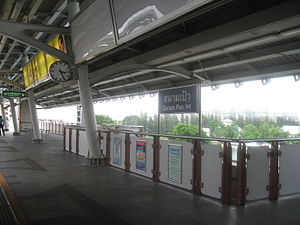
Sanam Pao BTS station
Railway station in Bangkok, Thailand
Distance: Approx. 1026 meters
Latitude and longitude: 13.77262222,100.54209167
Sanam Pao station (Thai: สถานีสนามเป้า, pronounced [sā.tʰǎː.nīː sā.nǎːm pâw]) is a BTS skytrain station, on the Sukhumvit Line in Phaya Thai District, Bangkok, Thailand. The station is on Phahon Yothin Road near Soi Phahon Yothin 3 in Sanam Pao area, among office towers, an army base, and the site of Royal Thai Army Radio and Television Channel 5.
Radio Thailand
National radio broadcaster of Thailand
Distance: Approx. 1593 meters
Latitude and longitude: 13.782137,100.559715
Radio Thailand (Thai: สถานีวิทยุกระจายเสียงแห่งประเทศไทย) is the public broadcasting radio station in Thailand owned by the National Broadcasting Services of Thailand based in Bangkok. The station has six FM national radio, 65 FM provincial radio, three AM national radio, 46 AM provincial radio and World Service. Some Radio Thailand provincial radio stations can be received in neighbor countries of Thailand like Malaysia, Laos, Cambodia and Myanmar.

Surasakmontree School
School in Bangkok, Thailand
Distance: Approx. 1347 meters
Latitude and longitude: 13.7759,100.5561
Surasakmontree School (Thai: โรงเรียนสุรศักดิ์มนตรี) is a Government School in Bangkok, Thailand.

Pradiphat Road
Road in Bangkok, Thailand
Distance: Approx. 1262 meters
Latitude and longitude: 13.79242778,100.54227778
Pradiphat Road (Thai: ถนนประดิพัทธ์, RTGS: Thanon Pradiphat, pronounced [tʰā.nǒn prā.dī.pʰát]) is a road in Bangkok, Thailand, mainly in Phaya Thai sub-district, Phaya Thai district. Pradipat is a straight road approximately 2 km (1.2 mi) long.

Mu Space
Distance: Approx. 413 meters
Latitude and longitude: 13.7780794,100.5433054
Mu Space and Advanced Technology Co., Ltd., operating under the name Mu Space Corp, is an aerospace manufacturer and internet service provider in Southeast Asia, founded by James Yenbamroong in June 2017.
Weather in this IP's area
few clouds
31 Celsius
35 Celsius
31 Celsius
32 Celsius
1011 hPa
62 %
1011 hPa
1009 hPa
10000 meters
4.12 m/s
10 degree
20 %
06:17:19
17:47:24

