Country:
 Singapore
Region:
City:
Latitude and Longitude:
Time Zone:
Postal Code:
IP information under different IP Channel
ip-api
Country
Region
City
ASN
Time Zone
ISP
Blacklist
Proxy
Latitude
Longitude
Postal
Route
IPinfo
Country
Region
City
ASN
Time Zone
ISP
Blacklist
Proxy
Latitude
Longitude
Postal
Route
MaxMind
Country
Region
City
ASN
Time Zone
ISP
Blacklist
Proxy
Latitude
Longitude
Postal
Route
Luminati
Country
SGASN
Time Zone
Asia/Singapore
ISP
MC-IX Matrix Internet Exchange RS-1
Latitude
Longitude
Postal
db-ip
Country
Region
City
ASN
Time Zone
ISP
Blacklist
Proxy
Latitude
Longitude
Postal
Route
ipdata
Country
Region
City
ASN
Time Zone
ISP
Blacklist
Proxy
Latitude
Longitude
Postal
Route
Popular places and events near this IP address
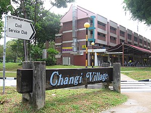
Changi
Planning Area in East Region ----, Singapore
Distance: Approx. 1409 meters
Latitude and longitude: 1.345,103.98319444
Changi () is a planning area located in the geographical region of Tanah Merah in the East Region of Singapore. Sharing borders with Pasir Ris and Tampines to the west, Changi Bay to the southeast, the South China Sea to the east and the Serangoon Harbour to the north. Changi, excluding the two water catchments and islands of Singapore, is the largest planning area by land size.

Changi Prison
Prison in Singapore
Distance: Approx. 1011 meters
Latitude and longitude: 1.357075,103.97364167
Changi Prison Complex, often known simply as Changi Prison, is a prison complex in the namesake district of Changi in the eastern part of Singapore. It is the oldest and largest prison in the country, covering an area of about 50 ha (120 acres). Opened in 1936, the prison has a rich history.
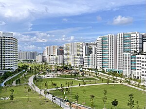
Tampines
Planning area and regional centre in East Region, Singapore
Distance: Approx. 1587 meters
Latitude and longitude: 1.34959167,103.95678889
Tampines ( TAM-pə-nees) is the regional centre of the East Region of Singapore. With a population of 274,360 living across its five subzones as of 2023, it is the second-most populous planning area in Singapore. It is home to approximately 5% of Singapore's population.
University of New South Wales Asia
Distance: Approx. 1098 meters
Latitude and longitude: 1.3408,103.9647
The University of New South Wales Asia (Abbreviation: UNSW Asia; Chinese: 亚洲新南威尔斯大学) was the first international university campus for the University of New South Wales in Singapore which opened on 12 March 2007. UNSW Asia was the first foreign university and fifth university in Singapore. On 23 May 2007, UNSW Asia Singapore campus announced its planned closure on 28 June 2007, at the end of the first semester due to financial issues and lower than expected student numbers.
Singapore Flying College
Flight school in Singapore
Distance: Approx. 965 meters
Latitude and longitude: 1.3453,103.9629
The Singapore Flying College (Abbreviation: SFC) is a CAAS approved flight school based in Singapore. Established in 1988 under the Singapore Airlines Group, it is the training school for cadet pilots with Singapore Airlines, Scoot and Singapore Airlines Cargo. The SFC headquarters is located at SIA Training Centre, Singapore, in close proximity to Changi Airport and is where the ATPL ground training phase is conducted.

Double Tenth incident
WWII massacre committed by Japanese in Singapore
Distance: Approx. 894 meters
Latitude and longitude: 1.35638889,103.97027778
The "Double Tenth incident" (双十節事件 Sōjūsetsu jiken) or "Double Tenth massacre" occurred on 10 October 1943, during the Second World War Japanese occupation of Singapore. The Kenpeitai—Japanese military police—arrested and tortured fifty-seven civilians and civilian internees on suspicion of their involvement in a raid on Singapore Harbour that had been carried out by Anglo-Australian commandos from Operation Jaywick. Three Japanese ships were sunk and three were damaged, but none of those arrested and tortured had participated in the raid, nor had any knowledge of it.
Changi Murals
Series of five WWII paintings by Stanley Warren
Distance: Approx. 1011 meters
Latitude and longitude: 1.357075,103.97364167
The Changi Murals are a set of five paintings of biblical themes painted by Stanley Warren, a British bombardier and prisoner-of-war (POW) interned at the Changi Prison, during the Japanese occupation of Singapore in the Second World War. His murals were completed under difficult conditions of sickness, limited materials and hardships. With a message of universal love and forgiveness, they helped to uplift the spirits of the POWs and the sick when they sought refuge in the prison chapel.

Changi Business Park
Distance: Approx. 1629 meters
Latitude and longitude: 1.33497222,103.96516667
The Changi Business Park (CBP) is a business park located in Changi South, in the eastern part of Singapore.
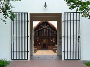
Changi Chapel and Museum
Distance: Approx. 1574 meters
Latitude and longitude: 1.36220278,103.97401667
The Changi Chapel and Museum is a war museum dedicated to Singapore's history during the Second World War and the Japanese occupation of Singapore. After the British Army was defeated by the Imperial Japanese Army in the Battle of Singapore, thousands of prisoners of war (POWs) were imprisoned in Changi prison camp for three and a half years. While interned there, the POWs built numerous chapels, one of which was named St George's Church.

Singapore University of Technology and Design
Public university in Tampines, Singapore
Distance: Approx. 1127 meters
Latitude and longitude: 1.341313,103.963757
The Singapore University of Technology and Design (SUTD) is a public autonomous university in Singapore.
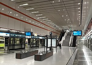
Upper Changi MRT station
Mass Rapid Transit station in Singapore
Distance: Approx. 1290 meters
Latitude and longitude: 1.3419,103.9614
Upper Changi MRT station is an underground Mass Rapid Transit station on the Downtown Line in Tampines planning area, Singapore, located under Upper Changi Road East. The station serves residential estates in the vicinity and the campus of the Singapore University of Technology and Design, which is linked via an underground linkway. The station, along with Fort Canning, is one of the longest stations along the line, at 205 meters.
Le Freeport
High-security storage facility in Singapore
Distance: Approx. 433 meters
Latitude and longitude: 1.345,103.9691
Le Freeport, formerly known as Singapore Freeport, is a high-security storage and display facility in Singapore. A majority stake is held by Natural Le Coultre S.A. of art dealer and shipper Yves Bouvier. Opened near Singapore Changi Airport in May 2010, the facility is modelled after similar institutions in Geneva and Luxembourg.
Weather in this IP's area
scattered clouds
27 Celsius
30 Celsius
26 Celsius
27 Celsius
1008 hPa
83 %
1008 hPa
1006 hPa
10000 meters
3.09 m/s
190 degree
40 %
06:55:11
19:02:14