Country:
 Malaysia
Region:
City:
Latitude and Longitude:
Time Zone:
Postal Code:
IP information under different IP Channel
ip-api
Country
Region
City
ASN
Time Zone
ISP
Blacklist
Proxy
Latitude
Longitude
Postal
Route
IPinfo
Country
Region
City
ASN
Time Zone
ISP
Blacklist
Proxy
Latitude
Longitude
Postal
Route
MaxMind
Country
Region
City
ASN
Time Zone
ISP
Blacklist
Proxy
Latitude
Longitude
Postal
Route
Luminati
Country
MYRegion
12
City
kotakinabalu
ASN
Time Zone
Asia/Kuching
ISP
TM TECHNOLOGY SERVICES SDN. BHD.
Latitude
Longitude
Postal
db-ip
Country
Region
City
ASN
Time Zone
ISP
Blacklist
Proxy
Latitude
Longitude
Postal
Route
ipdata
Country
Region
City
ASN
Time Zone
ISP
Blacklist
Proxy
Latitude
Longitude
Postal
Route
Popular places and events near this IP address

Kota Kinabalu International Airport
Airport serving Kota Kinabalu, Sabah, Malaysia
Distance: Approx. 2712 meters
Latitude and longitude: 5.94472222,116.05861111
Kota Kinabalu International Airport (KKIA) (IATA: BKI, ICAO: WBKK) is an international airport in Kota Kinabalu, the state capital of Sabah, Malaysia. It is located approximately 8 km (5.0 mi) southwest of the city centre. In 2019, over 9 million passengers passed through the airport, making it the second busiest airport in Malaysia after Kuala Lumpur International Airport in terms of passenger movements & aircraft movements and the third busiest in terms of cargo handled.
Tanjung Aru
Sub-district in Sabah, Malaysia
Distance: Approx. 1878 meters
Latitude and longitude: 5.94555556,116.05027778
Tanjung Aru is a sub-district of Kota Kinabalu in Sabah, of Malaysia. Its main feature is its beach called Tanjung Aru Beach which stretches to over 2 kilometres long along with new skyscrapers. This beach has a lot of Casuarina equisetifolia trees (aru) there naming this town.
1976 Sabah Air GAF Nomad crash
1976 Malaysian aviation accident
Distance: Approx. 2860 meters
Latitude and longitude: 5.96221667,116.06181111
The Double Six Crash, also known as the Double Six Tragedy (referring to 6 June), was a crash, involving a GAF N-22B Nomad of Sabah Air, which took place on 6 June 1976 at Kota Kinabalu, Malaysia, killing several local political leaders, including two top leaders - Tun Fuad Stephens and Datuk Peter Mojuntin.
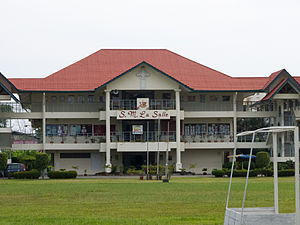
La Salle Secondary School, Kota Kinabalu
National secondary school in Malaysia
Distance: Approx. 1744 meters
Latitude and longitude: 5.953,116.0523
La Salle Secondary School, Kota Kinabalu (Malay: Sekolah Menengah La Salle Kota Kinabalu) is a co-educational secondary school for boys and girls (mostly boys) and one of the oldest schools in Kota Kinabalu on the coast of Borneo in East Malaysia. It was established in 1953 by Rev. Fr.
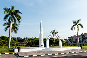
Double Six Monument
Monument in Sembulan, Kota Kinabalu
Distance: Approx. 2860 meters
Latitude and longitude: 5.96221667,116.06181111
The Double Six Monument (Malay: Tugu Peringatan Double Six) is a memorial located at the Sembulan neighbourhood of Kota Kinabalu, Sabah, Malaysia which marks the site of 6 June 1976 fatal plane crash known as the Double Six Tragedy bearing the first Chief Minister of Sabah, Tun Fuad Stephens, as well as six other State ministers.
Aseana College
College in Sabah, Malaysia
Distance: Approx. 3175 meters
Latitude and longitude: 5.96338889,116.06444444
Aseana College is a college in Kota Kinabalu, Sabah, Malaysia. Founded in 2008, the college provide courses on medical sciences. It is located on two campuses, with the main and administrative centre located in Sembulan, while the second campus is located kilometres away from the main campus.
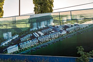
Aeropod
Distance: Approx. 2625 meters
Latitude and longitude: 5.94722222,116.05888889
The Aeropod is a mixed development projects comprising hotel, a retail mall, retail offices, residential suites, corporate offices and green parks in Tanjung Aru, Kota Kinabalu, Sabah, Malaysia. The projects are being done in five stages. The projects also include a provision for light rail transit (LRT) in the Kota Kinabalu metropolitan, to improve the already available rail station in Tanjung Aru.

Sutera Harbour
Harbour in Kota Kinabalu, Sabah, Malaysia
Distance: Approx. 2827 meters
Latitude and longitude: 5.96944444,116.05833333
Sutera Harbour is a resort located in the city of Kota Kinabalu, Sabah, Malaysia. It comprised two 5-star hotels, a 27-hole Graham Marsh-designed golf course, a 104-berth marina and an exclusive golf and country club with extensive recreational facilities facing the South China Sea with a background of Tunku Abdul Rahman National Park. In 2014, Singapore-based GSH Corporation has acquired the resort.

Gleneagles Hospital Kota Kinabalu
Hospital in Sabah, Malaysia
Distance: Approx. 3348 meters
Latitude and longitude: 5.96809167,116.06440278
Gleneagles Kota Kinabalu Hospital is a private hospital in the city of Kota Kinabalu, Sabah, Malaysia. The hospital offers medical services including cardiac care, brain and nerve, orthopaedic and spine, endocrinology, oncology, women and children care.

Perdana Park
Park in Kota Kinabalu, Sabah, Malaysia
Distance: Approx. 1609 meters
Latitude and longitude: 5.95062778,116.05037222
Perdana Park is a recreational park in Tanjung Aru, Kota Kinabalu, Sabah, Malaysia.

Tanjung Aru railway station
Railway station in Tanjung Aru, Malaysia
Distance: Approx. 2750 meters
Latitude and longitude: 5.94758333,116.06022222
Tanjung Aru railway station (Malay: Stesen Keretapi Tanjung Aru) is one of four main railway station on the Western Sabah Railway Line located in Tanjung Aru, Kota Kinabalu, Sabah, Malaysia.

Tanjung Aru Library
A public library branch in Tanjung Aru, Sabah, Malaysia
Distance: Approx. 1795 meters
Latitude and longitude: 5.95127778,116.05236111
Tanjung Aru Library (Malay: Perpustakaan Tanjung Aru) is a public library in the Greater Kota Kinabalu area of Tanjung Aru, Sabah, Malaysia. It's also the first "Green" library in Malaysia.
Weather in this IP's area
few clouds
34 Celsius
41 Celsius
33 Celsius
34 Celsius
1009 hPa
66 %
1009 hPa
1009 hPa
10000 meters
2.57 m/s
20 %
06:08:00
18:19:27