Country:
 Australia
Region:
City:
Latitude and Longitude:
Postal Code:
Time Zone:
language:
User-Agent:
Proxy IP:
Blacklist:
IP information under different IP Channel
Luminati
115.130.33.170Country
AUASN
Time Zone
Australia/Sydney
Latitude
Longitude
Postal
Popular places and events near this IP address
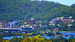
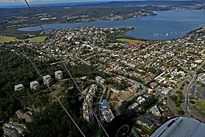
Gosford
City in New South Wales, Australia
Distance: Approx. 332 meters
Latitude and longitude: -33.42694444,151.34194444
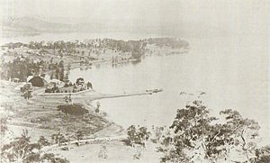
Gosford is a waterfront city at the northern end of Brisbane Water on the Central Coast in the state of New South Wales, Australia. The Gosford waterfront is known for its boating and scenic views on the shores of Brisbane Water. Gosford is the main commercial hub and gateway of the Central Coast.
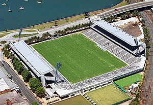
Central Coast Stadium
Sports venue in New South Wales, Australia
Distance: Approx. 683 meters
Latitude and longitude: -33.42833333,151.33805556
Central Coast Stadium (also known as Industree Group Stadium under naming rights and originally as Grahame Park) is a sports venue in Gosford, on the Central Coast of New South Wales, Australia. The stadium is home to the Central Coast Mariners Association football club which competes in the A-League. The stadium also hosts rugby league and rugby union fixtures on an ad hoc basis as well as other major social events.
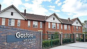
Gosford High School
School in Australia
Distance: Approx. 695 meters
Latitude and longitude: -33.41833333,151.34138889
Gosford High School (abbreviated as GHS) is a government-funded co-educational academically selective secondary day school, located in Gosford, in the Central Coast region of New South Wales, Australia. Established in 1928, the school enrolled approximately 1,063 students in 2023, from Year 7 to Year 12, of whom one percent identified as Indigenous Australians and fifty-seven percent were from a language background other than English. The school is operated by the NSW Department of Education; the principal is Michael Smith.
Gosford Hospital
Hospital in NSW, Australia
Distance: Approx. 617 meters
Latitude and longitude: -33.4197,151.3399
Gosford Hospital is a state owned public hospital in Gosford, New South Wales, Australia. It is part of the Central Coast Local Health District (CCLHD) which is a division of New South Wales Ministry of Health. Gosford Hospital provides a range of medical, surgical and maternity services to the Central Coast region of New South Wales.

Gosford railway station
Australian railway station
Distance: Approx. 192 meters
Latitude and longitude: -33.423687,151.341664
Gosford railway station is located on the Main Northern line in New South Wales, Australia. It serves the Central Coast city of Gosford, opening on 15 August 1887. Between January 1960 and April 1982, Gosford was the northern extremity of the electrified network.
East Gosford
Suburb of Central Coast, New South Wales, Australia
Distance: Approx. 1099 meters
Latitude and longitude: -33.432,151.351
East Gosford is a suburb of the Central Coast region of New South Wales, Australia, located immediately south-east of Gosford's town centre. It is part of the Central Coast Council local government area, and occupies an area previously inhabited by the Guringai (Wanangine) People. East Gosford is named after the Archibald Acheson, 2nd Earl of Gosford, with whom New South Wales Governor George Gipps served in Canada.
North Gosford
Suburb of Central Coast, New South Wales, Australia
Distance: Approx. 1243 meters
Latitude and longitude: -33.415,151.351
North Gosford is a south-eastern suburb of the Central Coast region of New South Wales, Australia immediately north-east of Gosford's central business district. It is part of the Central Coast Council local government area. North Gosford is notable for the region's largest private hospital and for Laycock Street Theatre, the region's principal theatre for live dramatic and musical theatre.
Point Frederick, New South Wales
Suburb of Central Coast, New South Wales, Australia
Distance: Approx. 1172 meters
Latitude and longitude: -33.432,151.335
Point Frederick is a suburb of the Central Coast region of New South Wales, Australia on a peninsula protruding into Brisbane Water 2 kilometres (1 mi) south-southeast of Gosford's central business district. It is part of the Central Coast Council local government area.
St Edward's College, East Gosford
Independent secondary day school in Australia
Distance: Approx. 1670 meters
Latitude and longitude: -33.43888889,151.34777778
St Edward's College is an independent Catholic secondary day school for boys, located in East Gosford, in the Central Coast region of New South Wales, Australia. The school was founded by the Congregation of Christian Brothers in 1953, who continue to run the school. Colloquially referred to as Eddies, the College caters for boys from Year 7 to Year 12.
Triple M Central Coast
Radio station in New South Wales, Australia
Distance: Approx. 1040 meters
Latitude and longitude: -33.4333,151.3466
The Central Coast's 107.7 Triple M (call-sign: 2GGO) is a commercial radio station based in Gosford, New South Wales, Australia. The broadcast area is the NSW Central Coast, a region that extends from southern Lake Macquarie to the Hawkesbury River. Originally called 2GO, it was the Central Coast's first radio station starting on the AM band with 1310, moving to 1323, and the final location on the AM band was 801 (to allow for stereo broadcasting).
Henry Kendall High School
High School in Australia
Distance: Approx. 922 meters
Latitude and longitude: -33.42111111,151.33444444
Henry Kendall High School is a co-educational comprehensive secondary day school, located in Gosford, in the Central Coast region of New South Wales, Australia.
Kibble Park
Distance: Approx. 268 meters
Latitude and longitude: -33.4267,151.3434
Kibble Park is an urban park in Gosford City, on the Central Coast of New South Wales, Australia. The park is a common location for public events in Gosford City.
Weather in this IP's area
light rain
16 Celsius
15 Celsius
13 Celsius
16 Celsius
1028 hPa
55 %
1028 hPa
1026 hPa
10000 meters
2.03 m/s
2.88 m/s
159 degree
81 %
19:00:00
11:00:00
The latest IP detection test
- 47.75.82.128
- 248.195.24.212
- 238.183.199.154
- 113.93.127.121
- 14.2.134.39
- 96.249.59.212
- 135.204.253.66
- 125.98.114.62
- 59.1.208.199
- 1.176.70.153