Country:
 Chinese mainland
Region:
City:
Latitude and Longitude:
Time Zone:
Postal Code:
IP information under different IP Channel
ip-api
Country
Region
City
ASN
Time Zone
ISP
Blacklist
Proxy
Latitude
Longitude
Postal
Route
IPinfo
Country
Region
City
ASN
Time Zone
ISP
Blacklist
Proxy
Latitude
Longitude
Postal
Route
MaxMind
Country
Region
City
ASN
Time Zone
ISP
Blacklist
Proxy
Latitude
Longitude
Postal
Route
Luminati
Country
CNASN
Time Zone
Asia/Shanghai
ISP
Huawei Cloud Service data center
Latitude
Longitude
Postal
db-ip
Country
Region
City
ASN
Time Zone
ISP
Blacklist
Proxy
Latitude
Longitude
Postal
Route
ipdata
Country
Region
City
ASN
Time Zone
ISP
Blacklist
Proxy
Latitude
Longitude
Postal
Route
Popular places and events near this IP address
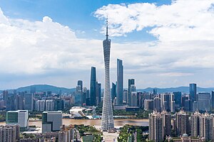
Guangzhou
Capital of Guangdong, China
Distance: Approx. 454 meters
Latitude and longitude: 23.13,113.26
Guangzhou, previously romanized as Canton or Kwangchow, is the capital and largest city of Guangdong province in southern China. Located on the Pearl River about 120 km (75 mi) north-northwest of Hong Kong and 145 km (90 mi) north of Macau, Guangzhou has a history of over 2,200 years and was a major terminus of the Silk Road. The port of Guangzhou serves as a transportation hub and Guangzhou is one of China's three largest cities.

Peasant Movement Training Institute
Distance: Approx. 735 meters
Latitude and longitude: 23.13033889,113.27133333
The Peasant Movement Training Institute or Peasant Training School was a school in Guangzhou (then romanized as "Canton"), China, operated from 1923 to 1926 during the First United Front between the Nationalists and Communists. It was located in a former Confucian temple built in the 14th century. The site now houses a museum to Guangzhou's revolutionary past.

Gongyuanqian station
Guangzhou Metro interchange station
Distance: Approx. 398 meters
Latitude and longitude: 23.12543,113.2642
Gongyuanqian Station (simplified Chinese: 公园前站; traditional Chinese: 公園前站; Jyutping: gung1 jyun2 cin4 zaam6; Cantonese Yale: Gūng'yúnchìhn Jaahm; lit. 'Front of the Park Station') is an interchange station of Line 1 and Line 2 of the Guangzhou Metro. It started operation on 28 June 1999 and is located under People's Park in Yuexiu District of Guangzhou.

Sun Yat-sen Memorial Hall station (Guangzhou Metro)
Guangzhou Metro station
Distance: Approx. 392 meters
Latitude and longitude: 23.1324,113.2633
Sun Yat-sen Memorial Hall Station (simplified Chinese: 纪念堂站; traditional Chinese: 紀念堂站; Jyutping: gei2 nim6 tong4 zaam6; Cantonese Yale: Géinihmtòhng Jaahm) is a station on Line 2 of the Guangzhou Metro that started operations on 29 December 2002. It is located under Dongfeng Middle Road (东风中路) and Lianxin Road (连新路) in the Yuexiu District of Guangzhou. The station is named for the Sun Yat Sen Memorial Hall, which was established in 1931 in memory of Dr.
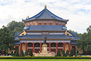
Sun Yat-sen Memorial Hall (Guangzhou)
Building in Guangzhou, Guangdong, China
Distance: Approx. 669 meters
Latitude and longitude: 23.134978,113.265004
The Sun Yat-sen or Zhongshan Memorial Hall is an octagon-shaped building in Guangzhou, capital of China's Guangdong Province. The hall was designed by Lu Yanzhi and was built with funds raised by local and overseas Chinese people in memory of Sun Yat-sen. Construction work commenced in 1929 and completed in 1931.

Battle of Canton (1857)
Distance: Approx. 702 meters
Latitude and longitude: 23.1265,113.258
The Battle of Canton (Chinese: 廣州城戰役) was fought by British and French forces against Qing China on 28–31 December 1857 during the Second Opium War. The British High Commissioner, Lord Elgin, was keen to take the city of Canton (Guangzhou) as a demonstration of power and to capture Chinese official Ye Mingchen, who had resisted British attempts to implement the 1842 Treaty of Nanking. Elgin ordered an Anglo-French force to take the town and an assault began on 28 December.
Guangwei Subdistrict, Guangzhou
Subdistrict of Guangzhou, China
Distance: Approx. 174 meters
Latitude and longitude: 23.13,113.263
Guangwei is a subdistrict of the Yuexiu District in Guangzhou City, Guangdong Province, southern China.
Liurong Subdistrict, Guangzhou
Subdistrict of Guangzhou, China
Distance: Approx. 460 meters
Latitude and longitude: 23.129187,113.259816
Liurong is a subdistrict of the Yuexiu District in Guangzhou City, Guangdong Province, southern China.
Guangta Subdistrict, Guangzhou
Subdistrict of Guangzhou, China
Distance: Approx. 832 meters
Latitude and longitude: 23.123111,113.259293
Guangta is a subdistrict of the Yuexiu District in Guangzhou City, Guangdong Province, southern China.
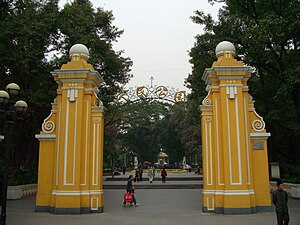
People's Park (Guangzhou)
Park in Guangzhou
Distance: Approx. 248 meters
Latitude and longitude: 23.12677778,113.26444444
People's Park (Chinese: 人民公园; pinyin: Rénmín Gōngyuán) is an urban public park in Yuexiu District in central Guangzhou, capital of Guangdong province in south China. Established in 1921, it is the first public park in the city, built on the site that had been the location of successive regional governments since the Sui dynasty (581–618 AD). Due to its central location, it is colloquially called Central Park (中央公园).
Second Battle of Guangzhou
Distance: Approx. 377 meters
Latitude and longitude: 23.13194444,113.26611111
The Second Battle of Guangzhou was fought between the rival armies of the Liangguang region in Southern China as part of the internal conflicts within the Kuomintang leading up to the Central Plains War. The previous month, the New Guangxi clique had fought the Sichuan clique at the Battle of Yichang in Hubei. The forces of the New Guangxi clique attacked Guangzhou from both their home province of Guangxi as well as Jiangxi.
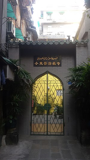
Xiaodongying Mosque
Mosque in Guangzhou, Guangdong, China
Distance: Approx. 564 meters
Latitude and longitude: 23.12955556,113.26977778
The Xiaodongying Mosque (simplified Chinese: 小东营清真寺; traditional Chinese: 小東營清真寺; pinyin: Xiǎodōngyíng Qīngzhēnsì) is a mosque in Yuexiu District, Guangzhou City, Guangdong Province, China.
Weather in this IP's area
moderate rain
28 Celsius
33 Celsius
28 Celsius
28 Celsius
1005 hPa
86 %
1005 hPa
1003 hPa
8781 meters
0.76 m/s
1.35 m/s
56 degree
88 %
06:15:38
18:23:47