Country:
 Vietnam
Region:
City:
Latitude and Longitude:
Time Zone:
Postal Code:
IP information under different IP Channel
ip-api
Country
Region
City
ASN
Time Zone
ISP
Blacklist
Proxy
Latitude
Longitude
Postal
Route
IPinfo
Country
Region
City
ASN
Time Zone
ISP
Blacklist
Proxy
Latitude
Longitude
Postal
Route
MaxMind
Country
Region
City
ASN
Time Zone
ISP
Blacklist
Proxy
Latitude
Longitude
Postal
Route
Luminati
Country
VNRegion
sg
City
hochiminhcity
ASN
Time Zone
Asia/Ho_Chi_Minh
ISP
FPT Telecom Company
Latitude
Longitude
Postal
db-ip
Country
Region
City
ASN
Time Zone
ISP
Blacklist
Proxy
Latitude
Longitude
Postal
Route
ipdata
Country
Region
City
ASN
Time Zone
ISP
Blacklist
Proxy
Latitude
Longitude
Postal
Route
Popular places and events near this IP address

State of Vietnam
1949–1954 constituent state of French Indochina
Distance: Approx. 3614 meters
Latitude and longitude: 10.8,106.65
The State of Vietnam (Vietnamese: Quốc gia Việt Nam; Chữ Hán: 國家越南; French: État du Viêt-Nam) was a governmental entity in Southeast Asia that existed from 1949 until 1955, first as a member of the French Union and later as a country (from 22 July 1954 to 26 October 1955). The state claimed authority over all of Vietnam during the First Indochina War, although large parts of its territory were controlled by the Democratic Republic of Vietnam. The state was created in 1949 by France as part of the French Union and was internationally recognised in 1950.
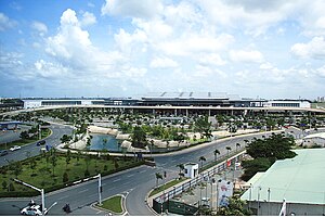
Tan Son Nhat International Airport
Commercial airport serving Ho Chi Minh City, Vietnam
Distance: Approx. 2890 meters
Latitude and longitude: 10.81888889,106.65194444
Tân Sơn Nhất International Airport (IATA: SGN, ICAO: VVTS) is an international airport serving Ho Chi Minh City, the most populous city in Vietnam. The airport is located in the Tân Bình district within the Ho Chi Minh City metropolitan area. It is the busiest airport in Vietnam, with 32.5 million passengers in 2016, 38.5 million passengers in 2018, and about 41 million passengers in 2023.
Tân Bình district
Urban district in Ho Chi Minh City, Vietnam
Distance: Approx. 4413 meters
Latitude and longitude: 10.79416667,106.65444444
Tân Bình is an urban district of Ho Chi Minh City, Vietnam. The city's international airport is situated in the district. It consists of 15 wards, from Ward 1 to Ward 15.
Tân Phú district, Ho Chi Minh City
Urban district in Ho Chi Minh City, Vietnam
Distance: Approx. 3315 meters
Latitude and longitude: 10.79222222,106.62527778
Tân Phú is an urban district of Hồ Chí Minh City, Vietnam. As of 2010, the district has a population of 407,924 and covers an area of 16 km². The district is divided into 11 small subsets which are called wards.

Gò Vấp district
Urban district in Ho Chi Minh City, Vietnam
Distance: Approx. 4986 meters
Latitude and longitude: 10.84166667,106.66666667
Gò Vấp is a district of Ho Chi Minh City. Since the 80s, it has undergone significant urbanization. It is more populous than most of the other districts.
Bình Hưng Hòa Cemetery
Inactive cemetery in Ho Chi Minh City, Vietnam
Distance: Approx. 3362 meters
Latitude and longitude: 10.79472222,106.6125
Binh Hung Hoa Cemetery (Vietnamese: Nghĩa trang Bình Hưng Hòa) was formerly the largest cemetery in the urban area of Ho Chi Minh City. It was located in the suburban outskirts of the city but due to the rapid urbanization of Ho Chi Minh City, the urban area eventually eclipsed the cemetery. There are several illegal houses built in and around the cemetery, and an estimated 300,000 residents live among the tombs.
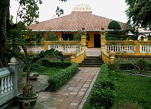
Nguyễn Công Trứ High School
Distance: Approx. 3513 meters
Latitude and longitude: 10.8391,106.6527
Nguyễn Công Trứ High School is a high school in Ho Chi Minh City, Vietnam. It is named after the Vietnamese General Nguyễn Công Trứ.
Vietnam People's Air Force Museum, Ho Chi Minh City
Distance: Approx. 4310 meters
Latitude and longitude: 10.805,106.66111111
The Vietnam People's Air Force Museum, Saigon or Bảo Tàng Phòng Không - Không Quân is located on Duong Thang Long (Thang Long Street) in the Phuong 4 District of Ho Chi Minh City. The museum is near to Tan Son Nhat International Airport and adjacent to the gate to Tan Son Nhut Air Base. The museum tells the history of the Vietnam People's Air Force (VPAF) in the Second Indochina War and the Cambodian-Vietnamese War.
Nguyễn Thượng Hiền High School
Public school in Ho Chi Minh City, Vietnam
Distance: Approx. 4513 meters
Latitude and longitude: 10.793075,106.65461667
Nguyễn Thượng Hiền High School (Vietnamese: Trường Trung học phổ thông Nguyễn Thượng Hiền) is a public high school in Hồ Chí Minh City, Vietnam. It was established in 1970 under the name Tân Bình High School. Being one of the four advanced public magnet schools in the city, Nguyễn Thượng Hiền ranks thirtieth nationally in the 2012 Vietnam university admission ranking.

Tet offensive attack on Tan Son Nhut Air Base
Part of the Vietnam War (1968)
Distance: Approx. 1462 meters
Latitude and longitude: 10.811,106.633
The attack on Tan Son Nhut Air Base, headquarters of the Republic of Vietnam Air Force (RVNAF) and the United States Air Force (USAF) 7th Air Force, occurred during the early hours of 31 January 1968. Tan Son Nhut Air Base was one of the major air bases used for offensive air operations within South Vietnam and for the support of United States Army and Army of the Republic of Vietnam (ARVN) ground operations. The attack by Vietcong (VC) and People's Army of Vietnam (PAVN) forces was one of several major attacks on Saigon in the first days of the Tet offensive.

81st Airborne Commando Battalion
Distance: Approx. 4397 meters
Latitude and longitude: 10.793,106.653
The 81st Airborne Commando Battalion (Vietnamese: Liên-đoàn 81 Biệt-cách Dù) was a unique special unit of the Vietnamese Rangers of the Republic of Vietnam Military Forces.
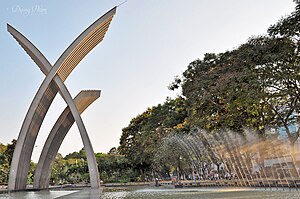
Hoàng Văn Thụ Park
Park in Ho Chi Minh City
Distance: Approx. 4814 meters
Latitude and longitude: 10.8012,106.6643
Hoàng Văn Thụ Park (Vietnamese: Công viên Hoàng Văn Thụ) is a park located in Ho Chi Minh City, Vietnam, to the south of Tan Son Nhat International Airport.
Weather in this IP's area
overcast clouds
25 Celsius
26 Celsius
25 Celsius
26 Celsius
1010 hPa
100 %
1010 hPa
1010 hPa
6000 meters
0.51 m/s
100 %
05:42:02
17:39:43