Country:
 Vietnam
Region:
City:
Latitude and Longitude:
Time Zone:
Postal Code:
IP information under different IP Channel
ip-api
Country
Region
City
ASN
Time Zone
ISP
Blacklist
Proxy
Latitude
Longitude
Postal
Route
IPinfo
Country
Region
City
ASN
Time Zone
ISP
Blacklist
Proxy
Latitude
Longitude
Postal
Route
MaxMind
Country
Region
City
ASN
Time Zone
ISP
Blacklist
Proxy
Latitude
Longitude
Postal
Route
Luminati
Country
VNRegion
hp
City
haiphong
ASN
Time Zone
Asia/Bangkok
ISP
FPT Telecom Company
Latitude
Longitude
Postal
db-ip
Country
Region
City
ASN
Time Zone
ISP
Blacklist
Proxy
Latitude
Longitude
Postal
Route
ipdata
Country
Region
City
ASN
Time Zone
ISP
Blacklist
Proxy
Latitude
Longitude
Postal
Route
Popular places and events near this IP address
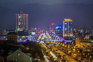
Haiphong
Municipality in Vietnam
Distance: Approx. 1794 meters
Latitude and longitude: 20.86513889,106.68383333
Hải Phòng, anglicized as Haiphong, is the third-largest city in Vietnam and is the principal port city of the Red River Delta. The municipality has an area of 1,526.52 km2 (589.39 sq mi), consisting of 8 urban districts and 7 rural districts. Two of the rural districts cover islands in the South China Sea: Bạch Long Vĩ and Cát Hải.
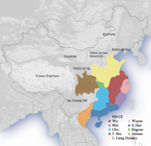
Battle of Bạch Đằng (938)
Distance: Approx. 4162 meters
Latitude and longitude: 20.8442,106.6317
At the Battle of Bạch Đằng River in 938 near Hạ Long Bay in northern Vietnam, the military force of the Viet-ruled domain of Tĩnh Hải quân, led by Ngô Quyền, a Viet lord, defeated the invading forces of the Chinese state of Southern Han and put an end to the Third Era of Northern Domination (Chinese ruled Vietnam). It was considered the turning point in Vietnamese history.

Roman Catholic Diocese of Hải Phòng
Roman Catholic diocese in Vietnam
Distance: Approx. 1277 meters
Latitude and longitude: 20.861,106.6807
The diocese of Hải Phòng (Latin: Dioecesis Haiphongensis) is a Roman Catholic diocese in northern Vietnam. The bishop is Vincent Nguyên Văn Ban, since 2022. The creation of the diocese in its present form was declared 24 November 1960.
Vietnam Maritime University
University in Haiphong, Vietnam
Distance: Approx. 3398 meters
Latitude and longitude: 20.837335,106.695632
Vietnam Maritime University (VMU; Vietnamese: Trường Đại học Hàng hải Việt Nam) is a university in Haiphong operated by the Ministry of Transport. The university was established on 1 April 1956 as Haiphong Maritime University. As of 2007, this is the only maritime university in Vietnam.
Hai Phong University
Distance: Approx. 2607 meters
Latitude and longitude: 20.8398,106.6879
Hai Phong University (Vietnamese: Đại học Hải Phòng) is a public university established on 22 July 1959 in Haiphong as . In 2000, this university was merged with some other higher institutions in Hai Phong to become Hai Phong Education University. On 9 April 2004, the Prime Minister of Vietnam signed edict 60/2004/QĐ-TTg, to rename this university Hai Phong University.
Hồng Bàng district
Urban district in Haiphong, Vietnam
Distance: Approx. 1035 meters
Latitude and longitude: 20.861982,106.662172
Hồng Bàng (Vietnamese: Quận Hồng Bàng) is a district (quận) of Haiphong, the third-largest city of Vietnam. The Hai Phong City Committee, the local administrative office, is located on Hoàng Diệu street, in the east of the district.
Ngô Quyền district
Urban district in Haiphong, Vietnam
Distance: Approx. 2775 meters
Latitude and longitude: 20.861297,106.69574
Ngô Quyền is an urban district (quận) of Hai Phong, the third largest city of Vietnam. It is named after King Ngô Quyền who defeated the Chinese at the famous Battle of Bạch Đằng River north of modern Haiphong and ended 1,000 years of Chinese domination dating back to 111 BC under the Han dynasty.

Lê Chân district
Urban district in Haiphong, Vietnam
Distance: Approx. 1358 meters
Latitude and longitude: 20.84979,106.680999
Lê Chân is an urban district (quận) of Hai Phong, the third largest city of Vietnam.
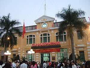
Haiphong station
Railway station in Haiphong, Vietnam
Distance: Approx. 1852 meters
Latitude and longitude: 20.856,106.6875
Hải Phòng station is one of the main railway stations on the Hanoi–Hai Phong railway in Vietnam. It serves the city of Hai Phong and opened in 1902. It is a terminus of the Sino-Vietnamese Railway, a French engineered narrow gauge railway completed in 1910, which was the first railway line to the Chinese city of Kunming.

Lạch Tray Stadium
Multi-sports stadium in Vietnam
Distance: Approx. 2033 meters
Latitude and longitude: 20.851779,106.6887428
The Lạch Tray Stadium is a multi-use stadium in Hai Phong, Vietnam. It is currently used mostly for association football matches and is the home stadium of Hải Phòng of the V.League 1. The stadium holds 17,400 spectators after renovation in 2021.
Hai Phong Medical University
Vietnamese university
Distance: Approx. 3285 meters
Latitude and longitude: 20.8428,106.698
Hai Phong University of Medicine and Pharmacy (Vietnamese: Trường Đại học Y Dược Hải Phòng, abbr.: HPMU) is a public university established in September 1979 in Haiphong, Vietnam. The university enrolls 450 full time students (each studying for 6 years) and 200 connected students (4 years) annually. Practice hospitals (with around 5,000 patient beds) are provided for students as medical facilities in Haiphong, Quang Ninh and Hai Duong.

Bính Bridge
Bridge in Hai Phong, Vietnam
Distance: Approx. 2166 meters
Latitude and longitude: 20.87527778,106.66777778
Bính Bridge (Vietnamese: Cầu Bính) is a cable-stayed bridge across the Cấm River connecting the Hai Phong city with Thủy Nguyên District and out to Quảng Ninh.
Weather in this IP's area
clear sky
26 Celsius
26 Celsius
26 Celsius
26 Celsius
1004 hPa
94 %
1004 hPa
1003 hPa
10000 meters
1.54 m/s
300 degree
05:41:00
17:54:50