113.22.165.50 - IP Lookup: Free IP Address Lookup, Postal Code Lookup, IP Location Lookup, IP ASN, Public IP
Country:
 Vietnam
Region:
City:
Location:
Time Zone:
Postal Code:
ISP:
ASN:
language:
User-Agent:
Proxy IP:
Blacklist:
IP information under different IP Channel
ip-api
Country
Region
City
ASN
Time Zone
ISP
Blacklist
Proxy
Latitude
Longitude
Postal
Route
db-ip
Country
Region
City
ASN
Time Zone
ISP
Blacklist
Proxy
Latitude
Longitude
Postal
Route
IPinfo
Country
Region
City
ASN
Time Zone
ISP
Blacklist
Proxy
Latitude
Longitude
Postal
Route
IP2Location
113.22.165.50Country
vnRegion
quang nam
City
tam ky
Time Zone
Asia/Ho_Chi_Minh
ISP
Language
User-Agent
Latitude
Longitude
Postal
ipdata
Country
Region
City
ASN
Time Zone
ISP
Blacklist
Proxy
Latitude
Longitude
Postal
Route
Popular places and events near this IP address

Tam Kỳ
Provincial city in Quảng Nam Province, Vietnam
Distance: Approx. 5 meters
Latitude and longitude: 15.56666667,108.48333333
Tam Kỳ () (IATA: TMK) is the capital city of Quảng Nam Province, in the South Central Coast of Vietnam. As of 2019 the city had a population of 122,374.

Phú Ninh District
District in South Central Coast, Vietnam
Distance: Approx. 8933 meters
Latitude and longitude: 15.56666667,108.4
Phú Ninh () is a district (huyện) of Quảng Nam province in the South Central Coast region of Vietnam. As of 2003 the district had a population of 114,048. The district covers an area of 167 km².
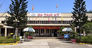
Tam Kỳ station
Railway station in Tam Kỳ, Vietnam
Distance: Approx. 1057 meters
Latitude and longitude: 15.55722222,108.48388889
Tam Kỳ station is one of the main railway stations on the North–South railway (Reunification Express) in Vietnam. It serves the city of Tam Kỳ.
An Hà
Commune and village in Bắc Giang Province, Vietnam
Distance: Approx. 1852 meters
Latitude and longitude: 15.58333333,108.48333333
An Hà is a commune (xã) and village in Lạng Giang District, Bắc Giang Province, in northeastern Vietnam.
Tam Kỳ Stadium
Distance: Approx. 2614 meters
Latitude and longitude: 15.56,108.50666667
Tam Kỳ Stadium (Vietnamese: Sân vận động Tam Kỳ) is a multi-use stadium located in Tam Kỳ, Quảng Nam Province, Vietnam. The stadium holds around 15,000 people and is mostly used for football matches.
Weather in this IP's area
overcast clouds
21 Celsius
22 Celsius
21 Celsius
21 Celsius
1014 hPa
96 %
1014 hPa
1008 hPa
9682 meters
2.24 m/s
4.37 m/s
313 degree
100 %