Country:
 Malaysia
Region:
City:
Latitude and Longitude:
Time Zone:
Postal Code:
IP information under different IP Channel
ip-api
Country
Region
City
ASN
Time Zone
ISP
Blacklist
Proxy
Latitude
Longitude
Postal
Route
IPinfo
Country
Region
City
ASN
Time Zone
ISP
Blacklist
Proxy
Latitude
Longitude
Postal
Route
MaxMind
Country
Region
City
ASN
Time Zone
ISP
Blacklist
Proxy
Latitude
Longitude
Postal
Route
Luminati
Country
MYRegion
13
City
kuching
ASN
Time Zone
Asia/Kuching
ISP
Binariang Berhad
Latitude
Longitude
Postal
db-ip
Country
Region
City
ASN
Time Zone
ISP
Blacklist
Proxy
Latitude
Longitude
Postal
Route
ipdata
Country
Region
City
ASN
Time Zone
ISP
Blacklist
Proxy
Latitude
Longitude
Postal
Route
Popular places and events near this IP address

Swinburne University of Technology Sarawak Campus
University in Kuching, Malaysia
Distance: Approx. 3048 meters
Latitude and longitude: 1.53194444,110.35694444
Swinburne University of Technology Sarawak Campus (SUTS) is the foreign branch campus of Swinburne University and is located in Kuching, Sarawak, Malaysia. Established in 2000, Swinburne Sarawak operates as a partnership between the Sarawak State Government and Swinburne Australia. The initiative behind the Sarawak campus is part of a long-term strategy by Swinburne Australia to "globalise its operations and provide its students with international living, working and learning opportunities".

Batu Lintang camp
Japanese-run WWII internment camp in Kuching, Sarawak
Distance: Approx. 4023 meters
Latitude and longitude: 1.53083333,110.34805556
Batu Lintang camp (also known as Lintang Barracks and Kuching POW camp) at Kuching, Sarawak on the island of Borneo was a Japanese-run internment camp during the Second World War. It was unusual in that it housed both Allied prisoners of war (POWs) and civilian internees. The camp, which operated from March 1942 until the liberation of the camp in September 1945, was housed in buildings that were originally British Indian Army barracks.
Batu Lintang National Secondary School
Co-ed public secondary school in Kuching, Sarawak, Malaysia
Distance: Approx. 4010 meters
Latitude and longitude: 1.532627,110.347654
Batu Lintang National Secondary School (Malay: Sekolah Menengah Kebangsaan Batu Lintang, abbreviation SMKBL) is a public secondary school located in Jalan College, Batu Lintang, Kuching, Sarawak, Malaysia.
Kuching High School
School in Kuching, Sarawak, Malaysia
Distance: Approx. 3948 meters
Latitude and longitude: 1.554611,110.34942
Kuching High School (KHS; Malay: SMJK Kuching High; Chinese: 古晋中学(国民型)), officially Kuching High National-type Secondary School (Malay: Sekolah Menengah Jenis Kebangsaan Kuching High; Chinese: 古晋中学(国民型)), is a public secondary school in Kuching, the capital of the Malaysian state of Sarawak. The school provides secondary education from Transition to Form 5, which culminates in the sitting of the public examinations of Form Three Assessment in Form 3 and the Malaysian Certificate of Education in Form 5. The school was founded in 1916 as a Chinese private school and from 1963 until today it became a Government-aided school.

Borneo Convention Centre Kuching
Event venue in Kuching, Malaysia
Distance: Approx. 3448 meters
Latitude and longitude: 1.5625,110.40555556
The Borneo Convention Centre Kuching (BCCK) is a convention centre located in Kuching, Sarawak, Malaysia. It is the first dedicated convention and exhibition centre in Borneo and the second-largest convention centre in Borneo after the Sabah International Convention Centre in Kota Kinabalu. Located approximately 8 km from the city centre, it aims to organize and attract local and international concerts, events, exhibitions and conventions to Sarawak.
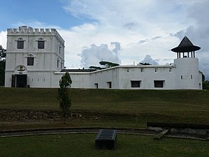
Fort Margherita
Fort in Sarawak, Malaysia
Distance: Approx. 4230 meters
Latitude and longitude: 1.56055556,110.34944444
Fort Margherita is an old fort constructed in 1879 by Charles Brooke, Rajah of Sarawak, situated in Kuching, Sarawak, Malaysia. The fort is an important landmark and monument in Sarawak's history which goes back to the Brooke dynasty. The fort, built in the style of an English castle, was designed to protect Kuching from being attacked by pirates.
Chung Hua Middle School No. 1
School in Kuching, Sarawak
Distance: Approx. 827 meters
Latitude and longitude: 1.546991,110.377181
Chung Hua Middle School No. 1 (Chinese: 古晋中华第一中学; Malay: Sekolah Menengah Persendirian Chung Hua) is a Chinese Independent High School located in Kuching, Sarawak, Malaysia. The school was established in 1958.
Tunku Putra School
Private national school in Kuching, Sarawak, Malaysia
Distance: Approx. 3934 meters
Latitude and longitude: 1.509759,110.397406
Tunku Putra-Help International School (TPHIS) is a coeducational, private international school located on The NorthBank, Kuching - Samarahan Expressway, Tabuan Jaya, 9350 Kuching. Established in 1997, Tunku Putra School caters for children from the ages of 3+ years, enrolled in Kindergarten, National-stream or International-stream classes. The School is named after Tunku Abdul Rahman.
Chinese History Museum
Museum in Kuching, Sawarak, Malaysia
Distance: Approx. 4150 meters
Latitude and longitude: 1.55766667,110.34875
The Chinese History Museum Kuching (Malay: Muzium Sejarah Cina Kuching) is a museum in Kuching, Sarawak, Malaysia. The museum is about the history of the Chinese people in Sarawak.

Tua Pek Kong Temple, Kuching
Chinese temple in Kuching, Malaysia
Distance: Approx. 4098 meters
Latitude and longitude: 1.55713444,110.34902028
Tua Pek Kong Temple (Chinese: 古晉大伯公廟) (also called as Siew San Teng Temple, Chinese: 壽山亭) is a Chinese temple situated near the waterfront of Kuching, Sarawak, Malaysia, opposite the Chinese History Museum. It is the oldest temple in the city and formed a part of the Kuching Heritage Trail.
ST3 Shopping Mall
Shopping mall in Kuching, Sarawak, Malaysia
Distance: Approx. 3007 meters
Latitude and longitude: 1.53604,110.356101
Simpang Tiga Three Shopping Mall, more commonly known as ST3 Shopping Mall, is an integrated shopping mall and serviced apartment complex in Kuching, Sarawak, Malaysia. Located at Jalan Simpang Tiga, it was opened in December 2012. The 8-storey serviced apartments sitting above the shopping mall is known as "Citadines Uplands Kuching Apartments" which is operated by The Ascott, a subsidiary of CapitaLand.
The Spring Shopping Mall
Shopping mall in Kuching, Sarawak, Malaysia
Distance: Approx. 2854 meters
Latitude and longitude: 1.535619,110.357612
The Spring Shopping Mall is a shopping mall in Kuching, Sarawak, Malaysia. Located at Persiaran Spring, it was opened in January 2008. It was the largest mall in Sarawak since its establishment until Boulevard Shopping Mall opened in 2013.
Weather in this IP's area
few clouds
25 Celsius
26 Celsius
25 Celsius
26 Celsius
1006 hPa
89 %
1006 hPa
1006 hPa
10000 meters
1.54 m/s
170 degree
20 %
06:29:30
18:36:38