Country:
 The Philippines
Region:
City:
Latitude and Longitude:
Time Zone:
Postal Code:
IP information under different IP Channel
ip-api
Country
Region
City
ASN
Time Zone
ISP
Blacklist
Proxy
Latitude
Longitude
Postal
Route
IPinfo
Country
Region
City
ASN
Time Zone
ISP
Blacklist
Proxy
Latitude
Longitude
Postal
Route
MaxMind
Country
Region
City
ASN
Time Zone
ISP
Blacklist
Proxy
Latitude
Longitude
Postal
Route
Luminati
Country
PHRegion
00
City
paranaquecity
ASN
Time Zone
Asia/Manila
ISP
Converge ICT Solutions Inc.
Latitude
Longitude
Postal
db-ip
Country
Region
City
ASN
Time Zone
ISP
Blacklist
Proxy
Latitude
Longitude
Postal
Route
ipdata
Country
Region
City
ASN
Time Zone
ISP
Blacklist
Proxy
Latitude
Longitude
Postal
Route
Popular places and events near this IP address
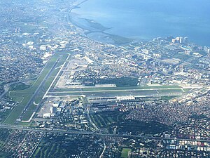
Ninoy Aquino International Airport
Commercial airport serving Metro Manila, Philippines
Distance: Approx. 380 meters
Latitude and longitude: 14.50833333,121.01972222
Ninoy Aquino International Airport (NAIA NA-ee-YAH) (IATA: MNL, ICAO: RPLL) — also known as Manila International Airport (MIA) — is the main international airport serving Metro Manila in the Philippines. Located between the cities of Pasay and Parañaque, about 7 kilometers (4.3 mi) south of Manila proper and southwest of Makati, it is the main gateway for travelers to the Philippines and serves as a hub for PAL Express and Philippine Airlines. It is also the main operating base for AirSWIFT, Cebgo, Cebu Pacific, and Philippines AirAsia.

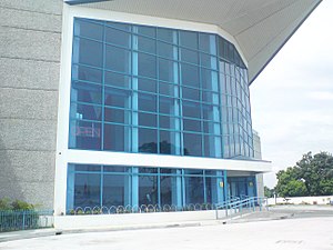
Shrine of St. Therese of the Child Jesus
Roman Catholic church in Pasay, Philippines
Distance: Approx. 1791 meters
Latitude and longitude: 14.521265,121.016021
The Shrine of St. Thérèse of the Child Jesus is a Roman Catholic church located in Pasay, Philippines, across the main entrance of Ninoy Aquino International Airport Terminal 3. Dedicated to Saint Thérèse de Lisieux, the church is classified as a diocesan shrine governed by the Military Ordinariate of the Philippines.

Mahatma Gandhi International School, Pasay
Private international school in Pasay, Philippines
Distance: Approx. 926 meters
Latitude and longitude: 14.50607,121.02666
The Mahatma Gandhi International School was a private international school located in Pasay, adjacent to Merville Park subdivision, Metro Manila, Philippines. Established in 2002, the school offered the International Baccalaureate Diploma Programme and the International General Certificate of Secondary Education for students from Kindergarten to Grade 12.

Newport World Resorts
Resort in Metro Manila, Philippines
Distance: Approx. 1517 meters
Latitude and longitude: 14.51881,121.01994
Newport World Resorts (formerly Resorts World Manila) is an integrated resort, located in Newport City, opposite Ninoy Aquino International Airport (NAIA) Terminal 3, in Pasay, Metro Manila, Philippines. The resort is owned and operated by Travellers International Hotel Group, Inc. (TIHGI), a joint venture between Alliance Global Group and Genting Hong Kong.

Newport Performing Arts Theater
Distance: Approx. 1523 meters
Latitude and longitude: 14.51888889,121.01972222
The Newport Performing Arts Theater (NPAT), also known as simply Newport Theater, is a performing arts center on the grounds of Newport World Resorts in Pasay, Metro Manila, the Philippines. It is a modern multi-purpose theater named after its location in the Newport Mall and entertainment complex connected to the integrated resort in the 25-hectare (62-acre) Newport City township. The 1,500-seat facility opened in 2010 and holds the widest stage in the Philippines.
Resorts World Manila attack
2017 shooting and arson in the Philippines
Distance: Approx. 1517 meters
Latitude and longitude: 14.51881,121.01994
The Resorts World Manila attack was an attack that took place at the Resorts World Manila (now Newport World Resorts) entertainment complex in Newport City, Pasay, Philippines. 38 were killed and 70 were injured when a gunman caused a stampede after he set fire to casino tables and slot machine chairs around midnight on June 2, 2017. The gunman moved to a storage area to steal casino chips from the venue but later committed suicide following a confrontation with the responding police.
Old Nayong Pilipino
Distance: Approx. 1464 meters
Latitude and longitude: 14.51444444,121.00833333
The Old Nayong Pilipino, officially the Nayong Pilipino Cultural Park, was a cultural theme park near Ninoy Aquino International Airport in Pasay, Metro Manila.

XiamenAir Flight 8667
2018 aviation incident
Distance: Approx. 231 meters
Latitude and longitude: 14.50658333,121.01641667
XiamenAir Flight 8667 was a scheduled international passenger flight from Xiamen Gaoqi International Airport in Xiamen, China, to Ninoy Aquino International Airport in Manila, Philippines. On 16 August 2018, the Boeing 737-85C (WL) operating this flight skidded off the runway while attempting to land in poor weather conditions. After leaving the runway, the aircraft hit obstacles that tore off the left engine and the left main gear.
Philippine Air Force Aerospace Museum
Aerospace museum in Pasay, Philippines
Distance: Approx. 1241 meters
Latitude and longitude: 14.5164,121.0192
The Philippine Air Force Aerospace Museum is an aerospace museum located within the premises of Colonel Jesus Villamor Air Base in Pasay, Philippines.
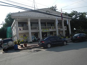
Moonwalk, Parañaque
Barangay in Parañaque, Metro Manila, Philippines
Distance: Approx. 1541 meters
Latitude and longitude: 14.49185833,121.01467222
Moonwalk, officially Barangay Moonwalk, is an urban barangay located in the second district of Parañaque, Philippines. As of the 2020 census, the population was 72,520. The barangay was created on April 3, 1978.
Philippine Village Hotel
Hotel in Pasay, Philippines
Distance: Approx. 1052 meters
Latitude and longitude: 14.51176,121.01098
Philippine Village Hotel (colloquially PVH) is an abandoned hotel located within the Nayong Pilipino Complex, next door to Ninoy Aquino International Airport, in Pasay City, Metro Manila, Philippines. Designed by National Artist Juan Nakpil, it was hailed as the first airport hotel in the Philippines. The hotel now owned by the Government Service Insurance System (GSIS) used to be the in the hands of Pampanga-based Enriquez-Panlilio family, who are involved in the real estate and shipping industry ( and are also the same owners of the Silahis International Hotel).

Vitalez
Barangay in Parañaque, Metro Manila, Philippines
Distance: Approx. 1350 meters
Latitude and longitude: 14.50824444,121.00595
Vitalez, officially Barangay Vitalez, is an urban barangay located in the first district of Parañaque, Philippines. Located near Ninoy Aquino International Airport, it is the smallest barangay in the city. As of the 2020 census, the population was 5,100.
Weather in this IP's area
scattered clouds
32 Celsius
39 Celsius
31 Celsius
32 Celsius
1010 hPa
69 %
1010 hPa
1008 hPa
10000 meters
2.24 m/s
2.68 m/s
162 degree
27 %
05:46:02
17:40:38