113.161.13.7 - IP Lookup: Free IP Address Lookup, Postal Code Lookup, IP Location Lookup, IP ASN, Public IP
Country:
Region:
City:
Location:
Time Zone:
Postal Code:
ISP:
ASN:
language:
User-Agent:
Proxy IP:
Blacklist:
IP information under different IP Channel
ip-api
Country
Region
City
ASN
Time Zone
ISP
Blacklist
Proxy
Latitude
Longitude
Postal
Route
db-ip
Country
Region
City
ASN
Time Zone
ISP
Blacklist
Proxy
Latitude
Longitude
Postal
Route
IPinfo
Country
Region
City
ASN
Time Zone
ISP
Blacklist
Proxy
Latitude
Longitude
Postal
Route
IP2Location
113.161.13.7Country
Region
quang binh
City
dong hoi
Time Zone
Asia/Ho_Chi_Minh
ISP
Language
User-Agent
Latitude
Longitude
Postal
ipdata
Country
Region
City
ASN
Time Zone
ISP
Blacklist
Proxy
Latitude
Longitude
Postal
Route
Popular places and events near this IP address

Đồng Hới
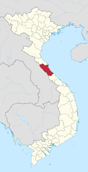
Provincial city in Quảng Bình, Vietnam
Distance: Approx. 40 meters
Latitude and longitude: 17.48305556,106.59972222
Đồng Hới () is the capital city of Quảng Bình Province in the north central coast of Vietnam. The city's area is 155.71 km2 (60.12 sq mi). Population as per the 2019 census was 133,672.
Quảng Bình University
Distance: Approx. 553 meters
Latitude and longitude: 17.4858,106.6045
Quảng Bình University is a university established in 2006 after merging colleges with the Normal College in Đồng Hới city, the capital of Quảng Bình Province. The university accepts entry exam candidate registers as of 2007. It provides education at university level of teacher's training (normal) (including maths, physics, chemistry, biology, literature, history, geology), law, business administration and English language.

Nhật Lệ Beach
Beach in Vietnam
Distance: Approx. 2559 meters
Latitude and longitude: 17.467,106.583

Bàu Tró
Lake in Quảng Bình Province, Vietnam
Distance: Approx. 2581 meters
Latitude and longitude: 17.491389,106.622778
Bàu Tró (Bàu in Vietnamese dialect means pond) is a lake in Đồng Hới city, Quảng Bình Province, Vietnam. This lake is an important fresh water supply for more than 130,000 inhabitants of Đồng Hới. Bàu Tró is better known for archaeological findings by French archaeologists during French Indochina periods.

Đá Nhảy Beach
Beach on the shore of the East Sea, Vietnam
Distance: Approx. 2559 meters
Latitude and longitude: 17.467,106.583
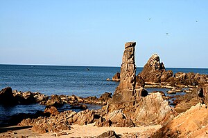
Đá Nhảy Beach is a beautiful beach on the shore of the East Sea, 40 km north of Đồng Hới city, Quảng Bình Province, Vietnam. Đá Nhảy in Vietnamese means "the rocks that jump", referring to the topographical feature of this beach which sees thousands rock reaching the sea, surrounding small fine sand beaches suitable for sea bathing. This is one of the most important attraction sites in Quảng Bình, along with Phong Nha-Kẻ Bàng National Park (a UNESCO World Heritage Site and Bang Spa.
Battle of Đồng Hới
Part of the Vietnam War (1972)
Distance: Approx. 40 meters
Latitude and longitude: 17.48305556,106.59972222
The Battle of Đồng Hới was a clash between United States Navy warships and Vietnam People's Air Force (VPAF) MiG-17F fighter bombers and shore batteries on 19 April 1972, during the Vietnam War. This was the second time U.S. warships faced an air attack since the end of World War II, after the USS Liberty incident. The Battle for Đồng Hới Gulf involved fierce firefights when Navy ships attempted to stop North Vietnamese troops and supplies transiting the coast highway in North Vietnam from reaching the battle front in Quảng Trị Province.

Đồng Hới station
Railway station in Vietnam
Distance: Approx. 1481 meters
Latitude and longitude: 17.47,106.6
Đồng Hới station is one of the main railway stations on the North–South railway (Reunification Express) in Vietnam. It serves the city of Đồng Hới, the provincial capital of Quảng Bình Province. The station is 450 km south of Hanoi, 160 km north of Huế, 1280 km north of Saigon station.

Đồng Hải
Urban ward in Quảng Bình, Vietnam
Distance: Approx. 3100 meters
Latitude and longitude: 17.46555556,106.6225
Đồng Hải is an urban ward (phường) in Đồng Hới, Quảng Bình Province, in Vietnam. It covers an area of 1.93 km2 and has a population of 5,957.
Đồng Phú, Quảng Bình
Urban ward in Quảng Bình, Vietnam
Distance: Approx. 1498 meters
Latitude and longitude: 17.4783,106.6131
Đồng Phú is an urban ward (phường) in Đồng Hới, Quảng Bình Province, in Vietnam. It covers an area of 3.81 km2 and has a population of 8016.

Bắc Nghĩa
Urban ward in Quảng Bình, Vietnam
Distance: Approx. 3557 meters
Latitude and longitude: 17.455,106.58444444
Bắc Nghĩa is an urban ward (phường) in Đồng Hới, Quảng Bình Province, in Vietnam. It covers an area of 7.76 km2 and has a population of 6981.
Đức Ninh Đông
Urban ward in Quảng Bình, Vietnam
Distance: Approx. 3332 meters
Latitude and longitude: 17.4556,106.6119
Đức Ninh Đông is an urban ward (phường) in Đồng Hới, Quảng Bình Province, in Vietnam. It covers an area of 3.13 km2 and has a population of 4726.
Quang Phú
Commune and village in Quảng Bình, Vietnam
Distance: Approx. 3491 meters
Latitude and longitude: 17.5142,106.6056
Quang Phú is a commune (xã) and village in Đồng Hới, Quảng Bình Province, in Vietnam.
Weather in this IP's area
overcast clouds
14 Celsius
14 Celsius
14 Celsius
14 Celsius
1022 hPa
90 %
1022 hPa
1013 hPa
10000 meters
8.09 m/s
12.46 m/s
344 degree
100 %
