Country:
Region:
City:
Latitude and Longitude:
Time Zone:
Postal Code:
IP information under different IP Channel
ip-api
Country
Region
City
ASN
Time Zone
ISP
Blacklist
Proxy
Latitude
Longitude
Postal
Route
Luminati
Country
ASN
Time Zone
Asia/Kuching
ISP
Bigband Sdn Bhd
Latitude
Longitude
Postal
IPinfo
Country
Region
City
ASN
Time Zone
ISP
Blacklist
Proxy
Latitude
Longitude
Postal
Route
db-ip
Country
Region
City
ASN
Time Zone
ISP
Blacklist
Proxy
Latitude
Longitude
Postal
Route
ipdata
Country
Region
City
ASN
Time Zone
ISP
Blacklist
Proxy
Latitude
Longitude
Postal
Route
Popular places and events near this IP address

Puchong
Town in Selangor, Malaysia
Distance: Approx. 442 meters
Latitude and longitude: 3.03555556,101.61722222
Puchong is a major town and a parliamentary constituency in the Petaling District, in the state of Selangor, Malaysia. Bordering Kuala Lumpur, it is part of the Greater Kuala Lumpur area. It is bordered by Petaling Jaya in the north, Subang Jaya in the west, Cyberjaya and Putrajaya in the south, and Seri Kembangan in the east.

Taylor's College
College in Petaling, Selangor, Malaysia
Distance: Approx. 3557 meters
Latitude and longitude: 3.06361111,101.6175
Taylor's College is an independent college in Malaysia, offering the Cambridge A Levels as well as the South Australian Certificate of Education. It is ranked among the top Cambridge A Level colleges in Southeast Asia. Taylor's College was established in 1969 by George Archibald Taylor and George Leighton Taylor.
Kinrara Academy Oval
Cricket stadium
Distance: Approx. 3261 meters
Latitude and longitude: 3.04777778,101.6425
Kinrara Academy Oval was a cricket stadium located at Bandar Kinrara, Puchong, Selangor, near Kuala Lumpur, Malaysia. Constructed in 2003, it hosted its first recorded match in 2005 when Bhutan Under-17s played Kuwait Under-17s in the Asian Cricket Council Under-17 Cup. The stadium, which could seat 4,000 spectators, was closed on 30 June 2022.

Bandar Puteri Puchong
Place in Selangor, Malaysia
Distance: Approx. 1763 meters
Latitude and longitude: 3.017,101.624
Bandar Puteri Puchong (Chinese: 蒲种公主城) is an affluent residential and commercial township in Puchong, Selangor, Malaysia. It was developed by the IOI Group, same as Bandar Puchong Jaya and Bandar Kinrara served as main residential hub of Puchong town. Within the township is a bustling commercial centre filled with a variety of businesses and services, including many major banks, a variety of eateries, a wet market - Puteri Mart in Bandar Puteri 5, and a hypermarket - Hero Market, in the building where Giant used to occupy located in Bandar Puteri 1.

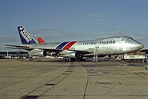
Flying Tiger Line Flight 66
1989 cargo plane crash in Kuala Lumpur, Malaysia
Distance: Approx. 2952 meters
Latitude and longitude: 3.0153,101.6389
Flying Tiger Line Flight 66 was a scheduled international cargo flight from Singapore Changi Airport to Hong Kong's Kai Tak Airport via a stopover at Kuala Lumpur International Airport, Malaysia. On February 19, 1989, the FedEx-owned Boeing 747-249F-SCD crashed while on its final approach. The aircraft impacted a hillside 437 ft (133 m) above sea level and 12 km (7.5 mi; 6.5 nmi) from Kuala Lumpur, resulting in all four occupants being killed.

IOI Puchong Jaya LRT station
Distance: Approx. 1856 meters
Latitude and longitude: 3.04808333,101.62088889
IOI Puchong Jaya LRT station is a light rapid transit station at Puchong Jaya, a township in Puchong, Selangor. It is located near IOI Mall, and its name was taken from IOI Group and Bandar Puchong Jaya, and not under the Station Naming Rights Programme run by Prasarana. It is operated under the Sri Petaling Line network as found in the station signage.

Pusat Bandar Puchong LRT station
Distance: Approx. 284 meters
Latitude and longitude: 3.03327778,101.61602778
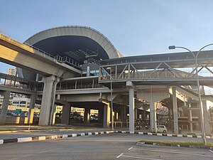
Pusat Bandar Puchong LRT station is a light rapid transit station at Puchong Town Centre, in Puchong, Selangor. It is operated under the Sri Petaling Line network, between Taman Perindustrian Puchong and IOI Puchong Jaya station. The station is located just beside the busy Damansara-Puchong Expressway (LDP).

Taman Perindustrian Puchong LRT station
Transit station in Puchong, Malaysia
Distance: Approx. 1100 meters
Latitude and longitude: 3.02286111,101.6135
Taman Perindustrian Puchong LRT station (abbreviate as TPP LRT Station) is a Light Rapid Transit station at Puchong Industrial Park, in Puchong, Selangor, Malaysia. It is part of the Sri Petaling Line, which is situated between Bandar Puteri station and Pusat Bandar Puchong station. Like most other LRT stations operating in Klang Valley, this station is elevated.

Bandar Puteri LRT station
Distance: Approx. 1724 meters
Latitude and longitude: 3.01705556,101.61283333
Bandar Puteri LRT station is a Light Rapid Transit station situated in Bandar Puteri, Puchong. It is operated under the Sri Petaling Line network and is situated between Puchong Perdana and Taman Perindustrian Puchong station. Like most other LRT stations operating in Klang Valley, this station is elevated.

Puchong Perdana LRT station
Distance: Approx. 3027 meters
Latitude and longitude: 3.00777778,101.60497222
Puchong Perdana LRT station is a Light Rapid Transit station at Puchong Perdana, a township in Puchong, Selangor. It operates under the Sri Petaling Line network, which is situated between Bandar Puteri and Puchong Prima station. The station accommodates 2 side platforms with 2 tracks.
2016 Movida Bar grenade attack
Attack in Puchong, Selangor, Malaysia
Distance: Approx. 1652 meters
Latitude and longitude: 3.046236,101.620796
On 28 June 2016, a bar located in Puchong, Selangor, Malaysia, was attacked by two people who threw a grenade into the bar while 20 customers were watching the UEFA Euro 2016 match between Italy and Spain. The attack injured eight people, including one foreigner from China. The attackers left the scene on a motorcycle but were subsequently arrested.

Sekolah Menengah Kebangsaan Seksyen 3 Bandar Kinrara
Co-educational school in Selangor Darul Ehsan, Malaysia
Distance: Approx. 2784 meters
Latitude and longitude: 3.03811111,101.64219444
Sekolah Menengah Kebangsaan Seksyen 3 Bandar Kinrara or SMK Seksyen 3 Bandar Kinrara (Chinese: 金銮镇第三区国中, literally meaning Kinrara Section 3 Secondary School), is a secondary national school located in Jalan Kinrara 5B, Bandar Kinrara. In 2009, SMK Seksyen 3 Bandar Kinrara accommodated 691 male students and 614 female students, housing a total number of 1,305 students.
Weather in this IP's area
overcast clouds
25 Celsius
26 Celsius
24 Celsius
26 Celsius
1008 hPa
91 %
1008 hPa
1005 hPa
10000 meters
0.73 m/s
0.95 m/s
87 degree
100 %
06:59:34
18:58:08