112.79.63.128 - IP Lookup: Free IP Address Lookup, Postal Code Lookup, IP Location Lookup, IP ASN, Public IP
Country:
 India
IndiaRegion:
City:
Location:
Time Zone:
Postal Code:
ISP:
ASN:
language:
User-Agent:
Proxy IP:
Blacklist:
IP information under different IP Channel
ip-api
Country
Region
City
ASN
Time Zone
ISP
Blacklist
Proxy
Latitude
Longitude
Postal
Route
db-ip
Country
Region
City
ASN
Time Zone
ISP
Blacklist
Proxy
Latitude
Longitude
Postal
Route
IPinfo
Country
Region
City
ASN
Time Zone
ISP
Blacklist
Proxy
Latitude
Longitude
Postal
Route
IP2Location
112.79.63.128Country
inRegion
west bengal
City
lakhyabad
Time Zone
ISP
Language
User-Agent
Latitude
Longitude
Postal
ipdata
Country
Region
City
ASN
Time Zone
ISP
Blacklist
Proxy
Latitude
Longitude
Postal
Route
Popular places and events near this IP address

Panchet
Census Town in Jharkhand, India
Distance: Approx. 9859 meters
Latitude and longitude: 23.69,86.76
Panchet is a census town in Nirsa CD block in Dhanbad Sadar subdivision of Dhanbad district in the Indian state of Jharkhand.
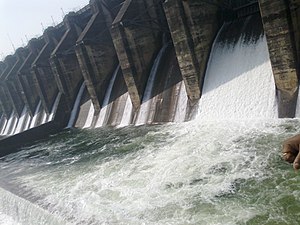
Panchet Dam
Dam in Jharkhand and Purulia district, West Bengal
Distance: Approx. 8278 meters
Latitude and longitude: 23.67805556,86.74694444
Panchet Dam was the last of the four multi-purpose dams included in the first phase of the Damodar Valley Corporation (DVC). It was constructed across the Damodar River at Panchet in Dhanbad district in the Indian state of Jharkhand, and opened in 1959.

Sindri Assembly constituency
Constituency of the Jharkhand legislative assembly in India
Distance: Approx. 9897 meters
Latitude and longitude: 23.748,86.706
Sindri Assembly constituency is an assembly constituency in the Indian state of Jharkhand.

Telkupi
Distance: Approx. 6132 meters
Latitude and longitude: 23.666362,86.606561
Telkupi (or Tailakampi) is a submerged location of archaeological interest in Purulia district of West Bengal, India. The area, along with most of the temples situated there, was submerged in 1959 as a consequence to the construction of a dam across Damodar river at Panchet in Dhanbad district, then in Bihar.

Kaliasole
Village in Jharkhand, India
Distance: Approx. 8384 meters
Latitude and longitude: 23.7413,86.6554
Kaliasole (also spelled Keliasole and Keliyasole) is a village in Kaliasole (community development block) in Dhanbad Sadar subdivision of Dhanbad district of State Capital Ranchi in the Indian state of Jharkhand.
Achkoda
Village in West Bengal, India
Distance: Approx. 4306 meters
Latitude and longitude: 23.6385,86.6378
Achkoda (sometimes spelled Anchkoda) is a village in the Neturia CD block in the Raghunathpur subdivision of the Purulia district in the state of West Bengal, India.
Kaliasole (community development block)
Community development block in Jharkhand, India
Distance: Approx. 8384 meters
Latitude and longitude: 23.7413,86.6554
Kaliasole is a community development block that forms an administrative division in Dhanbad Sadar subdivision of Dhanbad district, Jharkhand state, India. There are twenty (20) panchayats under Kaliasole CD Block.
Kalubathan
Village in Jharkhand, India
Distance: Approx. 9970 meters
Latitude and longitude: 23.7550776,86.6508657
Kalubathan is a village in Kaliasole (also spelled Keliasole and Keliyasole) Gram panchayat and comes under Kaliasole (community development block) in Dhanbad Sadar subdivision of Dhanbad district in the Indian state of Jharkhand. Kalubathan is surrounded by natural beauty and villages like Kaliasole, Simuldone, Kayrabank, Dainkata, Lakshipur, Patharkua, Dhobari, Urma, Dumurya, Daldali, Bandrabad is an admirable place with almost all the necessary facilities available. Kalubathan Railway Station (station code: KAO) is situated in Kalubathan is an important Railway Station in the Eastern Railway zone of Asansol Division.
Weather in this IP's area
clear sky
21 Celsius
20 Celsius
21 Celsius
21 Celsius
1015 hPa
33 %
1015 hPa
995 hPa
10000 meters
1.04 m/s
0.87 m/s
31 degree
6 %