112.79.211.231 - IP Lookup: Free IP Address Lookup, Postal Code Lookup, IP Location Lookup, IP ASN, Public IP
Country:
 India
IndiaRegion:
City:
Location:
Time Zone:
Postal Code:
ISP:
ASN:
language:
User-Agent:
Proxy IP:
Blacklist:
IP information under different IP Channel
ip-api
Country
Region
City
ASN
Time Zone
ISP
Blacklist
Proxy
Latitude
Longitude
Postal
Route
db-ip
Country
Region
City
ASN
Time Zone
ISP
Blacklist
Proxy
Latitude
Longitude
Postal
Route
IPinfo
Country
Region
City
ASN
Time Zone
ISP
Blacklist
Proxy
Latitude
Longitude
Postal
Route
IP2Location
112.79.211.231Country
inRegion
uttar pradesh
City
renukut
Time Zone
Asia/Kolkata
ISP
Language
User-Agent
Latitude
Longitude
Postal
ipdata
Country
Region
City
ASN
Time Zone
ISP
Blacklist
Proxy
Latitude
Longitude
Postal
Route
Popular places and events near this IP address

Khariya
Census town in Uttar Pradesh, India
Distance: Approx. 9277 meters
Latitude and longitude: 24.11666667,83.03333333
Khariya is a census town in Sonbhadra district in the Indian state of Uttar Pradesh.
Pipri
Town in Uttar Pradesh, India
Distance: Approx. 4049 meters
Latitude and longitude: 24.18,83
Pipri is a town and a nagar panchayat in Sonbhadra district in the Indian state of Uttar Pradesh.
Renukoot
Town in Uttar Pradesh, India
Distance: Approx. 335 meters
Latitude and longitude: 24.2,83.03
Renukoot is a town and a nagar panchayat in Sonbhadra district in the Indian state of Uttar Pradesh. It is 68 km south from the district headquarters Robertsganj. Renukoot is well known for the Hindalco aluminium plant and Rihand Dam.

Rihand Dam
Dam in Sonbhadra, Uttar Pradesh
Distance: Approx. 2578 meters
Latitude and longitude: 24.2025,83.00805556
Rihand Dam also known as Govind Ballabh Pant Sagar, is the second largest dam of India by volume (storage) next only to Indirasagar Dam of Madhya Pradesh. The reservoir of Rihand Dam, called Govind Ballabh Pant Sagar, is India's largest artificial lake. Rihand Dam is a concrete gravity dam located at Pipri in Sonbhadra District in Uttar Pradesh, India.
Muirpur Airport
Domestic airport in Uttar Pradesh, India
Distance: Approx. 8319 meters
Latitude and longitude: 24.12583333,83.04333333
Muirpur Airport also spelled as Myorpur Airport is an upcoming airport, situated at Myorpur approx 12 km (7.5 mi) from the Renukut in the Sonbhadra district in the Indian state of Uttar Pradesh. Airport is developing by upgrading the existing government airstrip. It serves nearby towns, Northern Coalfields Limited (NCL) (coal fields), NTPC projects Renukut and Robertsganj, the Other towns of Sonbhadra and Singrauli district of Madhya Pradesh.
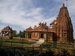
Renukeshwar Mahadev Temple
Hindu Temple in Uttar Pradesh, India
Distance: Approx. 1473 meters
Latitude and longitude: 24.2125,83.03805556
Renukeshwar Mahadev Temple is situated in Renukoot in Sonbhadra district, Uttar Pradesh. It is located adjoining the Rihand River which is also called Renu River, from where this temple got its name. The temple is dedicated to Mahadev or Lord Shiva.
Weather in this IP's area
clear sky
19 Celsius
17 Celsius
19 Celsius
19 Celsius
1014 hPa
28 %
1014 hPa
979 hPa
10000 meters
2.55 m/s
2.38 m/s
229 degree