Country:
 Indonesia
Region:
City:
Latitude and Longitude:
Time Zone:
Postal Code:
IP information under different IP Channel
ip-api
Country
Region
City
ASN
Time Zone
ISP
Blacklist
Proxy
Latitude
Longitude
Postal
Route
IPinfo
Country
Region
City
ASN
Time Zone
ISP
Blacklist
Proxy
Latitude
Longitude
Postal
Route
MaxMind
Country
Region
City
ASN
Time Zone
ISP
Blacklist
Proxy
Latitude
Longitude
Postal
Route
Luminati
Country
IDRegion
jb
City
cirebon
ASN
Time Zone
Asia/Jakarta
ISP
BIZNET NETWORKS
Latitude
Longitude
Postal
db-ip
Country
Region
City
ASN
Time Zone
ISP
Blacklist
Proxy
Latitude
Longitude
Postal
Route
ipdata
Country
Region
City
ASN
Time Zone
ISP
Blacklist
Proxy
Latitude
Longitude
Postal
Route
Popular places and events near this IP address

Cirebon
City in West Java, Indonesia
Distance: Approx. 883 meters
Latitude and longitude: -6.7071,108.5574
Cirebon (Indonesian pronunciation: [t͡ʃirə'bɔn], formerly rendered Cheribon or Chirebon in English) is a port city on the northern coast of the Indonesian island of Java. It is the only coastal city of West Java, located about 40 km west of the provincial border with Central Java, approximately 297 km (185 mi) east of Jakarta, at 6°43′S 108°34′E. It had a population of 296,389 at the 2010 census and 333,303 at the 2020 census; the official estimate as at mid 2023 was 341,980 (comprising 171,638 males and 170,342 females). The built-up area of Cirebon reaches out from the city and into the surrounding regency of the same name; the official metropolitan area encompasses the whole of this regency as well as the city, and covers an area of 1,116.24 km2 (430.98 sq mi), with a 2010 census population of 2,363,585; the 2020 census total was 2,603,924 and the official estimate as at mid 2023 was 2,702,421.

Sumber, Cirebon
District in West Java, Indonesia
Distance: Approx. 8916 meters
Latitude and longitude: -6.75444444,108.48583333
Sumber (Sundanese: ᮞᮥᮙ᮪ᮘᮨᮁ; Javanese: ꦯꦸꦩ꧀ꦧꦺꦂ) is a district which serves as the regency seat of the Cirebon Regency of West Java, Indonesia. It is divided into 14 villages which are listed as follows (with their populations as at mid 2022): The first 12 of these 14 are classed as urban kelurahan (Babakan occupying 1.38 km2, Sumber 2.50 km2, Perbutulan 0.53 km2, Kaliwadas 1.76 km2, Pasalakan 1.62 km2, Watubelah 1.93 km2, Pejambon 1.44 km2, Gegunung 1.72 km2, Kemantren 0.75 km2, Sendang 0.74 km2, Tukmudal 2.30 km2 and Kenanga 1.86 km2), while the remaining 2 are classed as rural desa and are situated in the south of the district (Matangaji with an area of 2.48 km2 and Sidawangi 4.64 km2).

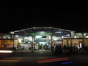
Cirebon railway station
Railway station in Indonesia
Distance: Approx. 646 meters
Latitude and longitude: -6.7052705,108.5554415
Cirebon Station (Indonesian: Stasiun Cirebon, Station Code: CN) also known as Cirebon Kejaksan Station is the main railway station in the Cirebon area located on Siliwangi Street, Kebonbaru, Kejaksan, Cirebon City, West Java Province. The station is located at DAOP 3 area as North Cross Line, but in this station there is also cross line in Purwokerto Station which is connected by South Cross Line in Kroya Station. Therefore, most of the trains both north and south lines stopped at this station, except economy class train which is stop at Cirebon Prujakan.
Cirebon Prujakan railway station
Railway station in Indonesia
Distance: Approx. 1854 meters
Latitude and longitude: -6.71944444,108.55861111
Cirebon Prujakan Station (CNP) is a railway station in Cirebon, West Java, Indonesia. The station is located at a height of 4 metres above sea level. It is located at Nyimas Gandasari Street, Pekalangan, Pekalipan, Cirebon.

Penggung Airport
Airport serving Cirebon, West Java, Indonesia
Distance: Approx. 5754 meters
Latitude and longitude: -6.75614444,108.53967222
Penggung Airport or Cakrabhuwana Airport (IATA: CBN, ICAO: WICD) is a small airport located in Penggung, Cirebon, West Java, Indonesia.
Great Mosque of Cirebon
Mosque in Cirebon, West Java, Indonesia
Distance: Approx. 3186 meters
Latitude and longitude: -6.72555556,108.57005556
The Great Mosque of Cirebon (Indonesian: Masjid Agung Cirebon), officially known as Masjid Agung Sang Cipta Rasa, is one of the oldest mosques in Indonesia. The mosque is located on the west side of the field, opposite the Kraton Kasepuhan, Cirebon, Indonesia. Believed to be first built in 1489, it has a tiered roof and is similar in style to the Agung Mosque in Banten.
2011 Cirebon bombing
Distance: Approx. 2266 meters
Latitude and longitude: -6.71666667,108.56666667
On April 15, 2011, a suicide bomber detonated an explosive device in a mosque in a police compound in the city of Cirebon, in West Java, Indonesia. The attack occurred around 12:20 WIB (UTC+7) during Friday prayers. The bomber was killed and at least 28 people were injured, most of whom were praying in the mosque.

Nasi jamblang
Indonesian rice dish
Distance: Approx. 2266 meters
Latitude and longitude: -6.71666667,108.56666667
Nasi jamblang is a typical food of Cirebon, West Java. The "jamblang" term comes from the name of the region to the west of the city of Cirebon, where food vendors first sold the dish. A characteristic feature of the dish is the use of teak leaves to pack the rice.
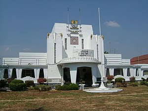
Cirebon City Hall
City hall in Cirebon City, Indonesia
Distance: Approx. 920 meters
Latitude and longitude: -6.707002,108.557767
Cirebon City Hall (Indonesian Balai Kota Cirebon) is a city hall in Cirebon City, Indonesia. The building shows implementation of the Dutch Amsterdam School Style in the colonial Dutch East Indies, now Indonesia.

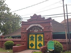
Red Mosque of Panjunan
Mosque in Cirebon, West Java, Indonesia
Distance: Approx. 2263 meters
Latitude and longitude: -6.717479,108.566065
The Red Mosque of Panjunan (Indonesian Masjid Merah Panjunan, Javanese Masjid Abang) is a Javanese mosque located in the village of Panjunan, Cirebon Regency, West Java, Indonesia. This 15th-century mosque with its Hindu architecture typical of Java is one of the oldest mosque in Indonesia.

Bima Stadium
Football stadium in Cirebon, Indonesia
Distance: Approx. 897 meters
Latitude and longitude: -6.70722222,108.5575
Bima Stadium is the name of a football stadium in the city of Cirebon, West Java, Indonesia. It was named after Bhima, a figure in the Mahabharata is used as the home venue for PSIT Cirebon and PS Gunung Jati Cirebon. The stadium has a capacity of 15,000.

Trusmi Batik Village
Center of Batik industry in Cirebon, West Java
Distance: Approx. 4868 meters
Latitude and longitude: -6.70308333,108.50563333
Trusmi Batik Village is a center of batik industry in Cirebon, West Java. The place is regarded as a tourist spot for batik art as well as local culinary. The village of Trusmi is located in the town of Plered, 4 km (2.5 mi) west of the city of Cirebon.
Weather in this IP's area
clear sky
33 Celsius
37 Celsius
33 Celsius
33 Celsius
1012 hPa
48 %
1012 hPa
1011 hPa
10000 meters
4.81 m/s
4.63 m/s
84 degree
10 %
05:42:58
17:44:22