112.39.25.116 - IP Lookup: Free IP Address Lookup, Postal Code Lookup, IP Location Lookup, IP ASN, Public IP
Country:
Region:
City:
Location:
Time Zone:
Postal Code:
ISP:
ASN:
language:
User-Agent:
Proxy IP:
Blacklist:
IP information under different IP Channel
ip-api
Country
Region
City
ASN
Time Zone
ISP
Blacklist
Proxy
Latitude
Longitude
Postal
Route
db-ip
Country
Region
City
ASN
Time Zone
ISP
Blacklist
Proxy
Latitude
Longitude
Postal
Route
IPinfo
Country
Region
City
ASN
Time Zone
ISP
Blacklist
Proxy
Latitude
Longitude
Postal
Route
IP2Location
112.39.25.116Country
Region
liaoning
City
panjin
Time Zone
Asia/Shanghai
ISP
Language
User-Agent
Latitude
Longitude
Postal
ipdata
Country
Region
City
ASN
Time Zone
ISP
Blacklist
Proxy
Latitude
Longitude
Postal
Route
Popular places and events near this IP address

Panjin
Prefecture-level city in Liaoning, People's Republic of China
Distance: Approx. 1296 meters
Latitude and longitude: 41.1177,122.0654
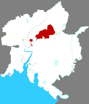
Panjin (simplified Chinese: 盘锦; traditional Chinese: 盤錦; pinyin: Pánjǐn) is a coastal prefecture-level city in central Liaoning province, People's Republic of China, situated on the northern shore of the Liaodong Bay. It borders Anshan to the east, Yingkou to the southeast, and Jinzhou to the west and north. It is the smallest city in both Liaoning and the entire Northeast China with an administrative area of 3,825 square kilometres (1,477 sq mi), and Liaoning's least populous city with a population of 1,389,691 people as of the 2020 census, all in the built-up (or metro) area made of the 2 urban districts and Dawa and Panshan counties now largely being conurbated.

Xinglongtai District
District in Liaoning, China
Distance: Approx. 4964 meters
Latitude and longitude: 41.1587,122.0699
Xinglongtai District (simplified Chinese: 兴隆台区; traditional Chinese: 興隆台區; pinyin: Xīnglóngtái Qū) is a district under the administration of the city of Panjin, Liaoning province, China. It has a total area of 194 square kilometres (75 sq mi) with many small exclaves in other districts, and a population of approximately 530,000 people in 2020. The district's postal code is 124010, and the district government is located on Shiyou Street.

Shuangtaizi District
District in Liaoning, People's Republic of China
Distance: Approx. 8270 meters
Latitude and longitude: 41.1906,122.0601
Shuangtaizi District (simplified Chinese: 双台子区; traditional Chinese: 雙檯子區; pinyin: Shuāngtáizi Qū) is an urban district under the administration of the prefectural city of Panjin in Liaoning province, People's Republic of China. The district's name came from the Shuangtaizi River, the old name (until 2011) of the modern-day lower Liao River, which flows through the southern edge of the district. It has a total area of 99.35 square kilometres (38.36 sq mi), and a population of approximately 200,000 people.
Panjin Jinxiu Stadium
Sports venue in Panjin, China
Distance: Approx. 1953 meters
Latitude and longitude: 41.11027778,122.07166667
Panjin Red Beach Sports Centre Jinxiu Stadium (Chinese: 盘锦红海滩体育中心锦绣体育场) or simply Panjin Jinxiu Stadium (Chinese: 盘锦锦绣体育场) is a multi-purpose stadium in Panjin, China. It is currently used mostly for association football matches. The stadium holds 35,600 people.
Weather in this IP's area
clear sky
-4 Celsius
-9 Celsius
-4 Celsius
-4 Celsius
1034 hPa
51 %
1034 hPa
1034 hPa
10000 meters
3.99 m/s
9.71 m/s
18 degree