Country:
 The Philippines
Region:
City:
Latitude and Longitude:
Time Zone:
Postal Code:
IP information under different IP Channel
ip-api
Country
Region
City
ASN
Time Zone
ISP
Blacklist
Proxy
Latitude
Longitude
Postal
Route
IPinfo
Country
Region
City
ASN
Time Zone
ISP
Blacklist
Proxy
Latitude
Longitude
Postal
Route
MaxMind
Country
Region
City
ASN
Time Zone
ISP
Blacklist
Proxy
Latitude
Longitude
Postal
Route
Luminati
Country
PHRegion
40
City
antipolocity
ASN
Time Zone
Asia/Manila
ISP
Philippine Long Distance Telephone Company
Latitude
Longitude
Postal
db-ip
Country
Region
City
ASN
Time Zone
ISP
Blacklist
Proxy
Latitude
Longitude
Postal
Route
ipdata
Country
Region
City
ASN
Time Zone
ISP
Blacklist
Proxy
Latitude
Longitude
Postal
Route
Popular places and events near this IP address
Cainta
Municipality in Rizal, Philippines
Distance: Approx. 1415 meters
Latitude and longitude: 14.57,121.12
Cainta, officially the Municipality of Cainta (Filipino: Bayan ng Cainta, IPA: [kɐʔɪnˈtaʔ]), is a 1st class urban municipality in the province of Rizal, Philippines. According to the 2020 census, it has a population of 376,933 people. It is one of the oldest municipalities in Luzon (founded on August 15, 1571) and has a land area of 4,299 hectares (10,620 acres). Cainta serves as the secondary gateway to the rest of Rizal province from Metro Manila.

Taytay, Rizal
Municipality in Rizal, Philippines
Distance: Approx. 2696 meters
Latitude and longitude: 14.56917,121.1325
Taytay, officially the Municipality of Taytay (Filipino: Bayan ng Taytay; IPA: [taɪˈtaɪ]), is a 1st class urban municipality in the province of Rizal, Philippines. It is also known as the Garments Capital of the Philippines. Conurbanated with Metro Manila, it is bounded by Cainta on the north, Pasig and Taguig on the west, Antipolo in the east and Angono on the south.
Sapang Baho River
River in National Capital Region, Philippines
Distance: Approx. 1899 meters
Latitude and longitude: 14.55,121.1
The Sapang Baho River is a river system that runs through Rizal Province and Marikina in the Philippines. The name, when literally translated, means "smelly creek". It is one of 21 tributaries of Laguna de Bay and is regularly monitored by the Laguna Lake Development Authority (LLDA) through one of its 15 river monitoring stations.
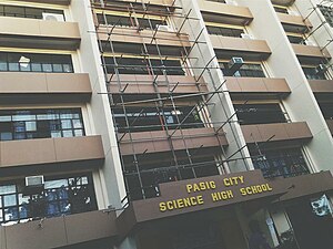
Pasig City Science High School
Public high school in Pasig, Philippines
Distance: Approx. 1629 meters
Latitude and longitude: 14.57511,121.09658
Pasig City Science High School is a specialized public secondary school in Pasig. It is under the administration of the local government of Pasig and is recognized by the Department of Education. The school offers scholarship programs for students of Pasig who are gifted in science and technology.
Siena College of Taytay
Roman Catholic college in Rizal, Philippines
Distance: Approx. 2696 meters
Latitude and longitude: 14.56916667,121.1325
Siena College of Taytay, also referred to by its acronym SCT, is a private, non-profit Catholic basic and higher education institution run by the Congregation of the Dominican Sisters of St. Catherine of Siena in Taytay, Rizal, Philippines. It was named St.
Saint Gabriel International School
Private international school in Pasig, Philippines
Distance: Approx. 1458 meters
Latitude and longitude: 14.5621,121.09468
Saint Gabriel International School, or (simplified Chinese: Saint Gabriel国际学校; traditional Chinese: Saint Gabriel國際學校; pinyin: Saint Gabriel guó jì xué xiào) or SGIS, is recognized by the Department of Education in Pasig City, Philippines, owned by Dr. Mildred A. Go, Ed. D..

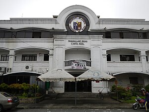
Cainta Church
Roman Catholic church in Rizal, Philippines
Distance: Approx. 1639 meters
Latitude and longitude: 14.578,121.1155
The Diocesan Shrine and Parish of Our Lady of Light, commonly known as Cainta Church, is a Roman Catholic parish church located along Andres Bonifacio Avenue in Barangay San Andres, Cainta, Rizal, in the Philippines. The church also operates a neighboring school, Cainta Catholic College. From its time of erection as a parish in 1760 until 1983, it belonged to the Archdiocese of Manila.
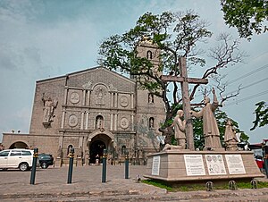
Taytay Church
Roman Catholic church in Rizal, Philippines
Distance: Approx. 2751 meters
Latitude and longitude: 14.57125,121.13258
The Minor Basilica and Parish of Saint John the Baptist, commonly known as Taytay Church, is a Roman Catholic church located in Taytay, Rizal, Philippines. It is under the jurisdiction of the Diocese of Antipolo.
Manuel I. Santos Memorial National High School
Public high school in Rizal, Philippines
Distance: Approx. 2777 meters
Latitude and longitude: 14.54684,121.12513
Manuel I. Santos Memorial National High School (MISMNHS) is a public secondary school in Sitio Lambak, San Juan, Taytay, Rizal, Philippines. It was formerly an annex building of Taytay National High School and now an independent public secondary school. The school is named after Manuel Ignacio Santos who was then served as Municipal Mayor of Taytay (1946-1947), (1952-1960) and (1980-1981).
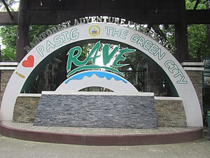
Pasig Rainforest Park
Distance: Approx. 1448 meters
Latitude and longitude: 14.573839,121.097662
Pasig Rainforest Park, also known as Pasig City Rainforest Adventure Experience (RAVE Rainforest Park) and Pasig Central Park, is a public park in Pasig, eastern Metro Manila, Philippines. It spans 8 hectares (20 acres), and is a mixed recreational and natural park with a mini-zoo. The rainforest park was opened to the public in 1977 with an initial area of 4.8 hectares (12 acres).

Pasig Revolving Tower
Mixed-Use in Metro Manila, Philippines
Distance: Approx. 2758 meters
Latitude and longitude: 14.55886111,121.08308333
The Pasig Revolving Tower is a 12-storey building in Pasig, Metro Manila, Philippines.

Napindan
Barangay in Taguig, Metro Manila, Philippines
Distance: Approx. 3061 meters
Latitude and longitude: 14.54025556,121.09608056
Napindan, officially Barangay Napindan, is one of the 38 barangays of Taguig, Metro Manila, Philippines. As of the 2020 census, the population was 24,437. It was one of the earlier barrios that was added to Taguig during the Spanish colonial period.
Weather in this IP's area
overcast clouds
33 Celsius
40 Celsius
32 Celsius
33 Celsius
1009 hPa
65 %
1009 hPa
1008 hPa
10000 meters
2.57 m/s
2.89 m/s
252 degree
95 %
05:44:06
18:02:48