Country:
 The Philippines
Region:
City:
Latitude and Longitude:
Time Zone:
Postal Code:
IP information under different IP Channel
ip-api
Country
Region
City
ASN
Time Zone
ISP
Blacklist
Proxy
Latitude
Longitude
Postal
Route
IPinfo
Country
Region
City
ASN
Time Zone
ISP
Blacklist
Proxy
Latitude
Longitude
Postal
Route
MaxMind
Country
Region
City
ASN
Time Zone
ISP
Blacklist
Proxy
Latitude
Longitude
Postal
Route
Luminati
Country
PHRegion
40
City
bacoor
ASN
Time Zone
Asia/Manila
ISP
Philippine Long Distance Telephone Company
Latitude
Longitude
Postal
db-ip
Country
Region
City
ASN
Time Zone
ISP
Blacklist
Proxy
Latitude
Longitude
Postal
Route
ipdata
Country
Region
City
ASN
Time Zone
ISP
Blacklist
Proxy
Latitude
Longitude
Postal
Route
Popular places and events near this IP address

Bacoor
Component city in Cavite, Philippines
Distance: Approx. 2721 meters
Latitude and longitude: 14.462422,120.964453
Bacoor (IPA: [bakoʔˈoɾ]), officially the City of Bacoor (Filipino: Lungsod ng Bacoor), is a 1st class component city in the province of Cavite, Philippines. According to the 2020 census, it has a population of 664,625 people, making it the 15th most populous city in the Philippines and the second largest city in the province of Cavite after Dasmariñas.
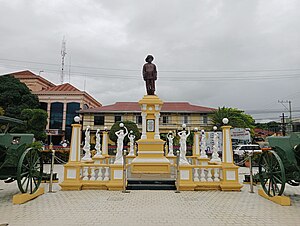
Imus
Capital (de jure) of Cavite, Philippines
Distance: Approx. 2951 meters
Latitude and longitude: 14.4297,120.9367
Imus (Tagalog pronunciation: [ˈʔimus]), officially the City of Imus (Filipino: Lungsod ng Imus), is a 1st class component city and de jure capital of the province of Cavite, Philippines. According to the 2020 census, it has a population of 496,794 people. It is the de jure capital of the province of Cavite, located 20 kilometers (12 mi) south of Metro Manila, when President Ferdinand Marcos decreed the transfer of the seat of the provincial government from Trece Martires on June 11, 1977.

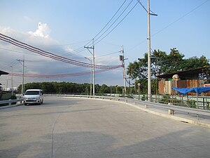
Manila–Cavite Expressway
Expressway in the Philippines
Distance: Approx. 2400 meters
Latitude and longitude: 14.46944444,120.9575
The Manila–Cavite Expressway (more popularly known as CAVITEX), signed as E3 of the Philippine expressway network and R-1 of Metro Manila's arterial road network, is a 14-kilometer-long (8.7 mi) controlled-access highway linking Manila to the southern province of Cavite in the Philippines. At its north end, it feeds into and from Roxas Boulevard in the city of Parañaque in Metro Manila, also part of R-1. At the south end, it splits into two termini, both along the north coast in Kawit, Cavite.
Zapote station
Distance: Approx. 2917 meters
Latitude and longitude: 14.47006,120.96294
Zapote station is an under-construction Light Rail Transit (LRT) station located on the LRT Line 1 (LRT-1) system in Bacoor, Cavite. Zapote differs from other LRT-1 stations in that it will be constructed at grade. It is part of the LRT-1 South Extension Project.
Talaba station
Distance: Approx. 2209 meters
Latitude and longitude: 14.46218,120.95957
Talaba station is an optional proposed station on the Manila Light Rail Transit System Line 1. The station will be located at the intersection of Aguinaldo Highway and Evangelista Street in Talaba III, Bacoor. Line 1 plan calls for an almost entirely elevated extension of approximately 11.7 km.
St. Dominic College of Asia
Private college in Cavite, Philippines
Distance: Approx. 2199 meters
Latitude and longitude: 14.45898,120.96027
The St. Dominic College of Asia, also referred to by its acronym SDCA, is a private co-educational basic and higher education institution in Bacoor, Cavite, Philippines. It was founded by Don Gregorio and Doña Dominga Andaman in 2003 and initially named St.
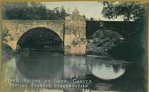
Bridge of Isabel II
Bridge in Imus, Cavite
Distance: Approx. 2873 meters
Latitude and longitude: 14.43019444,120.94027778
The Bridge of Isabel II is a historic bridge in the City of Imus in Cavite province, Philippines. The two-span stone arch bridge that was completed in 1857 was the site of the Battle of Imus, also known as the Battle of Imus River, on September 3, 1896 between the Filipino revolutionaries and the soldiers of the Spanish colonial government.

St. Michael the Archangel Parish of Binakayan
Church in Cavite, Philippines
Distance: Approx. 2018 meters
Latitude and longitude: 14.44731,120.92367
The Iglesia Catolica Apostolica Filipina Independiente – also known as Iglesia Filipina Independiente de Binakayan, is a Christian Church organized in Kawit, Cavite, Philippines, in 1902, under the Diocese of Cavite of the Philippine Independent Church.

Baldomero Aguinaldo Shrine
Historic house in Cavite, Philippines
Distance: Approx. 2006 meters
Latitude and longitude: 14.447709,120.923573
The Baldomero Aguinaldo Shrine is a single-detached house built by Baldomero Aguinaldo, cousin of Emilio Aguinaldo during the American colonial period in 1906 at Binakayan, Kawit, Cavite. Baldomero held several positions at the revolutionary government during the early 1900s. He became the head of the Kawit Chapter of the Katipunan, President of the KKK Magdalo Council, and Secretary of the Treasury in the 1897 Biak-na-Bato Republic.

Cuenca Ancestral House
Distance: Approx. 501 meters
Latitude and longitude: 14.45967222,120.94278889
The Cuenca Ancestral House (Bahay na Tisa) is a historic residential building in Bacoor, Cavite, Philippines.
Southern Tagalog Regional Hospital
Government hospital in Cavite, Philippines
Distance: Approx. 1793 meters
Latitude and longitude: 14.4414,120.94713
The Southern Tagalog Regional Hospital (STRH) is a tertiary level government hospital in the Philippines with an authorized bed capacity of one hundred (100). It is located in Bacoor, Cavite.
Island Cove (Cavite)
Island and gambling complex in Cavite, Philippines
Distance: Approx. 1909 meters
Latitude and longitude: 14.46117,120.92321
PAGCOR POGO Hub Covelandia is an online gambling complex hosted in Island Cove and Animal Island in Kawit, Cavite, Philippines. It formerly hosted a resort and leisure park owned by the Remulla political family. It now hosts a hub for Philippine Offshore Gaming Operators (POGOs).
Weather in this IP's area
few clouds
33 Celsius
39 Celsius
32 Celsius
33 Celsius
1008 hPa
59 %
1008 hPa
1008 hPa
10000 meters
6.69 m/s
270 degree
20 %
05:44:49
18:03:25