Country:
 The Philippines
Region:
City:
Latitude and Longitude:
Time Zone:
Postal Code:
IP information under different IP Channel
ip-api
Country
Region
City
ASN
Time Zone
ISP
Blacklist
Proxy
Latitude
Longitude
Postal
Route
IPinfo
Country
Region
City
ASN
Time Zone
ISP
Blacklist
Proxy
Latitude
Longitude
Postal
Route
MaxMind
Country
Region
City
ASN
Time Zone
ISP
Blacklist
Proxy
Latitude
Longitude
Postal
Route
Luminati
Country
PHRegion
40
City
cainta
ASN
Time Zone
Asia/Manila
ISP
Eastern Telecoms Phils., Inc.
Latitude
Longitude
Postal
db-ip
Country
Region
City
ASN
Time Zone
ISP
Blacklist
Proxy
Latitude
Longitude
Postal
Route
ipdata
Country
Region
City
ASN
Time Zone
ISP
Blacklist
Proxy
Latitude
Longitude
Postal
Route
Popular places and events near this IP address
Pateros
Municipality in Metro Manila, Philippines
Distance: Approx. 898 meters
Latitude and longitude: 14.5448,121.0671
Pateros, officially the Municipality of Pateros (Tagalog: [pɐˈtɛɾɔs]; Filipino: Bayan ng Pateros), is the lone municipality of Metro Manila, Philippines. According to the 2020 census, it has a population of 65,227 people. This municipality is famous for its duck-raising industry and especially for producing balut, a Filipino delicacy, which is a boiled, fertilized duck egg.
Taguig River
River in National Capital Region, Philippines
Distance: Approx. 1432 meters
Latitude and longitude: 14.53269,121.06148
The Taguig River (Tagalog: Ilog ng Taguig), also known as the Taguig-Pateros River, is a river that serves as the easternmost border of the City of Taguig, with Pateros and Pasig. It is a tributary of the Pasig River.
Dambanang Kawayan
Roman Catholic church in Taguig, Philippines
Distance: Approx. 858 meters
Latitude and longitude: 14.54139,121.0806
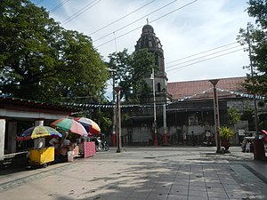
Dambana ng Kawayan, officially known as Saint John the Baptist Parish, is a Roman Catholic parish church located in Barangay Ligid-Tipas in Taguig, Philippines. This church of Tipas formerly belonged to the Immaculate Conception Parish of Pasig and later transferred to the Shrine of Saint Anne in Sta. Ana, Taguig City.

Simborio
Church in Taguig, Philippines
Distance: Approx. 1092 meters
Latitude and longitude: 14.5293,121.0734
The Simborio is a dome-shaped structure at the center of Sta. Ana Cemetery in Taguig in the Philippines. It was built by the Filipinos during the 18th century through the supervision of Spanish Friars.

Taguig Church
Roman Catholic church in Taguig, Philippines
Distance: Approx. 1357 meters
Latitude and longitude: 14.526944,121.073889
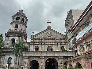
The Saint Anne Parish Church, also known as Santa Ana Church or also known in its formal name as the Minor Basilica and Archdiocesan Shrine Parish of St. Anne, is a Roman Catholic church and minor basilica located in Barangay Santa Ana, Taguig, Philippines. It is situated next to the Taguig River and across Plaza Quezon, where the statue of Manuel L. Quezon was erected when he was still serving as President of the Philippines.
Pateros Church
Roman Catholic church in Pateros, Philippines
Distance: Approx. 918 meters
Latitude and longitude: 14.54513889,121.06719444
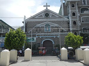
Pateros Church, also known as the San Roque Parish Church, is a Roman Catholic church under the order of the Augustinians located in the municipality of Pateros, Metro Manila, Philippines.
Tuktukan
Barangay in Taguig, Metro Manila, Philippines
Distance: Approx. 1238 meters
Latitude and longitude: 14.52804167,121.07177778
Tuktukan is one of the 38 barangays of Taguig, Metro Manila, Philippines. Since 1958, it is the center of the city (poblacion) as it is the location of the Taguig City Hall.

Felix Y. Manalo National Historical Landmark
Memorial and plaza in Taguig, Philippines
Distance: Approx. 928 meters
Latitude and longitude: 14.53357,121.07944
The Felix Y. Manalo National Historical Landmark, also known as the Felix Manalo Shrine, is a memorial and plaza in Taguig, Philippines recognized as a National Historical Landmark. The site marks the birthplace of the Iglesia ni Cristo founder and leader Felix Manalo.
Santa Ana, Taguig
Barangay in Taguig, Metro Manila, Philippines
Distance: Approx. 1327 meters
Latitude and longitude: 14.52771111,121.076625
Santa Ana is one of the 38 barangays of Taguig, Metro Manila, Philippines. It is one of the nine original barrios of Taguig. It is named after Saint Anne, who is the patroness of the barangay.

Ususan
Barangay in Taguig, Metro Manila, Philippines
Distance: Approx. 786 meters
Latitude and longitude: 14.53433,121.067619
Ususan is one of the 38 barangays of Taguig, Metro Manila, Philippines.
Calzada, Taguig
Barangay in Taguig, Metro Manila, Philippines
Distance: Approx. 1327 meters
Latitude and longitude: 14.52771111,121.076625
Calzada, also known as Calzada Tipas, is one of the 38 barangays of Taguig, Metro Manila in the Philippines.

Ibayo-Tipas
Barangay in Taguig, Metro Manila, Philippines
Distance: Approx. 1327 meters
Latitude and longitude: 14.52771111,121.076625
Ibayo-Tipas, also known as Ibayo Tipas,is one of the 38 barangays of Taguig, Metro Manila in the Philippines.
Weather in this IP's area
few clouds
32 Celsius
39 Celsius
32 Celsius
32 Celsius
1011 hPa
65 %
1011 hPa
1011 hPa
10000 meters
2.57 m/s
270 degree
20 %
05:44:15
18:02:56