Country:
 The Philippines
Region:
City:
Latitude and Longitude:
Time Zone:
Postal Code:
IP information under different IP Channel
ip-api
Country
Region
City
ASN
Time Zone
ISP
Blacklist
Proxy
Latitude
Longitude
Postal
Route
IPinfo
Country
Region
City
ASN
Time Zone
ISP
Blacklist
Proxy
Latitude
Longitude
Postal
Route
MaxMind
Country
Region
City
ASN
Time Zone
ISP
Blacklist
Proxy
Latitude
Longitude
Postal
Route
Luminati
Country
PHRegion
00
City
quezoncity
ASN
Time Zone
Asia/Manila
ISP
Eastern Telecoms Phils., Inc.
Latitude
Longitude
Postal
db-ip
Country
Region
City
ASN
Time Zone
ISP
Blacklist
Proxy
Latitude
Longitude
Postal
Route
ipdata
Country
Region
City
ASN
Time Zone
ISP
Blacklist
Proxy
Latitude
Longitude
Postal
Route
Popular places and events near this IP address

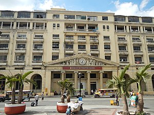
Manila Central Post Office
Neoclassical building in Manila, Philippines
Distance: Approx. 193 meters
Latitude and longitude: 14.5955,120.9791
The Manila Central Post Office, often called the Post Office Building, is the main postal office of Manila, which also serves as the headquarters of the Philippine Postal Corporation. It also houses the main mail sorting-distribution operations of the Philippines. It is located along the banks of the Pasig River in Lawton, Ermita and lies at the northern end of Liwasang Bonifacio.

Santa Cruz Bridge
Former bridge in Manila, Philippines
Distance: Approx. 74 meters
Latitude and longitude: 14.59680556,120.98041667
The Santa Cruz Bridge was a bridge that spanned the Pasig River in the city of Manila in the Philippines. The steel truss bridge was the fourth to span the river connecting the district of Santa Cruz from Plaza Goiti to Arroceros Street in the old city center of Manila. The construction of the bridge was started by the Spanish colonial government in Manila but completed by the Americans after gaining sovereignty of the country from Spain after the Spanish–American War.

Escolta Street
Historic street in Manila, Philippines
Distance: Approx. 158 meters
Latitude and longitude: 14.59778,120.97851
Escolta Street (Spanish: Calle de la Escolta) is a historic east–west street located in the old downtown district of Binondo in Manila, Philippines. It runs parallel to the Pasig River, from Quintin Paredes Road (Plaza Moraga) to Plaza Santa Cruz Road (Plaza Lacson). The street is home to several fine examples of early skyscraper design in the Philippines.

First United Building
Historic building in Manila, Philippines
Distance: Approx. 183 meters
Latitude and longitude: 14.5987,120.9794
The First United Building, formerly known and still commonly referred to as Perez-Samanillo Building, is an Art Deco building on Escolta Street in Binondo, Manila, Philippines. It was designed by Andrés P. Luna, the son of renowned painter Juan Luna, and was the tallest building in Manila when it was completed in 1928.

Regina Building
Historic building in Binondo, Manila, Philippines
Distance: Approx. 159 meters
Latitude and longitude: 14.5985,120.9795
Regina Building, previously known as Roxas Building, is a historic building located along Escolta Street in Binondo, Manila, Philippines. It was designed sequentially by Andrés Luna de San Pedro and Fernando H. Ocampo. The neoclassical beaux-arts commercial structure was built in 1915.

Calvo Building
Historic building in Manila, Philippines
Distance: Approx. 170 meters
Latitude and longitude: 14.597141,120.978221
The Calvo Building is a historic building along no. 266 Escolta corner Soda Streets, Binondo, Manila, Philippines. Built in 1938, owned by Doña Emiliana Mortera vda.
Don Roman Santos Building
Office building in Manila, Philippines
Distance: Approx. 181 meters
Latitude and longitude: 14.59869142,120.98015863
The Don Roman Santos Building is a neoclassical building located along the historic Escolta Street in Santa Cruz, Manila, Philippines. It fronts Plaza Lacson (formerly Plaza Goiti) which leads to directly to Carriedo Street or to Rizal Avenue. It was built in 1894 and expanded in 1957.

Santa Cruz Church (Manila)
Roman Catholic church in Manila, Philippines
Distance: Approx. 221 meters
Latitude and longitude: 14.599,120.9804
The Archdiocesan Shrine of the Blessed Sacrament, also known as the Our Lady of the Pillar Church or simply Santa Cruz Parish, is a Mission Revival Roman Catholic parish church in the district of Santa Cruz, Manila, Philippines. It is under the jurisdiction of the Archdiocese of Manila. The church was built when the arrabal (suburb) of Santa Cruz was established by the Jesuits in the early 17th century.

Natividad Building
Historic building in Manila, Philippines
Distance: Approx. 173 meters
Latitude and longitude: 14.598171,120.978638
The Natividad Building is a historic building along Escolta corner Tomas Pinpin, Binondo, Manila, Philippines. Designed by Philippine-born Spanish architect Fernando de la Cantera Blondeau, it is an outstanding example of beaux-arts architecture. It once housed the Philippine Insurance Commission.

Burke Building (Manila)
Historic Building in Manila, Philippines
Distance: Approx. 175 meters
Latitude and longitude: 14.598512,120.979083
Burke Building is a historic building along Escolta corner Burke, Binondo, Manila, Philippines. First built in 1919, it survived World War II and has gone major remodeling since. Named after cardiologist William J. Burke, the building is also known as the location of the first elevator in Manila.

Insular Ice Plant
Defunct ice plant in the Philippines
Distance: Approx. 216 meters
Latitude and longitude: 14.59553,120.98098
The Insular Ice and Cold Storage Plant also known simply as the Insular Ice Plant was an ice production and storage facility in Ermita, Manila, Philippines. It was said that the facility was leased or operated between 1933 up until 1943 by San Miguel Brewery, which had acquired "Oriental Brewery and Ice Co." from Hong Kong back in 1919. It was the oldest ice manufacturing plant in Southeast Asia.
HUB: Make Lab
Shopping mall in Metro Manila, Philippines
Distance: Approx. 199 meters
Latitude and longitude: 14.59888889,120.97980556
HUB: Make Lab also known as the Hub, is an adaptive reuse, incubator space for creative startups and artists which also acts as an alternative shopping center. Located within the former space occupied by Berg's Department Store in First United Building in Escolta St., Binondo, Manila, Philippines. Opened in 2016 after the success of the Saturday X Future Market, organized by the artist collective, 98B COLLABoratory along with the increasing foot traffic in Escolta during its first street party known as the Escolta Block Party.
Weather in this IP's area
light rain
30 Celsius
37 Celsius
30 Celsius
31 Celsius
1007 hPa
78 %
1007 hPa
1006 hPa
10000 meters
1.42 m/s
2.46 m/s
265 degree
38 %
05:47:43
17:34:23