Country:
 Japan
JapanRegion:
City:
Latitude and Longitude:
Time Zone:
Postal Code:
IP information under different IP Channel
ip-api
Country
Region
City
ASN
Time Zone
ISP
Blacklist
Proxy
Latitude
Longitude
Postal
Route
IPinfo
Country
Region
City
ASN
Time Zone
ISP
Blacklist
Proxy
Latitude
Longitude
Postal
Route
MaxMind
Country
Region
City
ASN
Time Zone
ISP
Blacklist
Proxy
Latitude
Longitude
Postal
Route
Luminati
Country
JPRegion
12
City
ichihara
ASN
Time Zone
Asia/Tokyo
ISP
TOKAI Communications Corporation
Latitude
Longitude
Postal
db-ip
Country
Region
City
ASN
Time Zone
ISP
Blacklist
Proxy
Latitude
Longitude
Postal
Route
ipdata
Country
Region
City
ASN
Time Zone
ISP
Blacklist
Proxy
Latitude
Longitude
Postal
Route
Popular places and events near this IP address
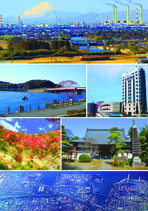
Ichihara, Chiba
City in Kantō, Japan
Distance: Approx. 2642 meters
Latitude and longitude: 35.49805556,140.11544444
Ichihara (市原市, Ichihara-shi) is a city, located in Chiba Prefecture, Japan. As of 1 December 2020, the city had an estimated population of 274,117 in 128,316 households and a population density of 240 persons per km2. The total area of the city is 368.20 square kilometres (142.16 sq mi).

ZA Oripri Stadium
Distance: Approx. 4258 meters
Latitude and longitude: 35.527974,140.071639
ZA Oripri Stadium (ゼットエーオリプリスタジアム) is a football and athletics stadium located in Ichihara, Japan. Completed in 1987, the stadium consists of a large main stand and several smaller stands in a ring. Approximately 500 seats are covered; the cold Ichihara winds tend to create an uncomfortable experience for most patrons.

Hamano Station
Railway station in Chiba, Japan
Distance: Approx. 3603 meters
Latitude and longitude: 35.5519,140.1323
Hamano station (浜野駅, Hamano-eki) is a passenger railway station located in Chūō-ku, Chiba, Chiba Prefecture, Japan, operated by the East Japan Railway Company (JR East).
Yawatajuku Station
Railway station in Ichihara, Chiba Prefecture, Japan
Distance: Approx. 1603 meters
Latitude and longitude: 35.536,140.1201
Yawatajuku station (八幡宿駅, Yawatajuku-eki) is a passenger railway station in the city of Ichihara, Chiba Prefecture, Japan, operated by the East Japan Railway Company (JR East).

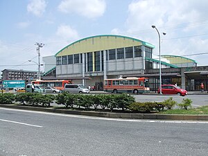
Goi Station
Railway station in Ichihara, Chiba Prefecture, Japan
Distance: Approx. 2762 meters
Latitude and longitude: 35.5129,140.0895
Goi station (五井駅, Goi-eki) is a railway station in Ichihara, Chiba, Japan, operated by the East Japan Railway Company (JR East) and the private railway operator Kominato Railway.

Chiharadai Station
Railway station in Ichihara, Chiba Prefecture, Japan
Distance: Approx. 4959 meters
Latitude and longitude: 35.5343,140.1705
Chiharadai Station (ちはら台駅, Chiharadai-eki) is a passenger railway station in the city of Ichihara, Chiba, Japan, operated by the Keisei Electric Railway.

Amaariki Station
Railway station in Ichihara, Chiba Prefecture, Japan
Distance: Approx. 4488 meters
Latitude and longitude: 35.48168333,140.12406389
Amaariki Station (海士有木駅, Amaariki-eki) is a railway station on the Kominato Line in Ichihara, Chiba Prefecture, Japan, operated by the Kominato Railway.

Kazusa-Murakami Station
Railway station in Ichihara, Chiba Prefecture, Japan
Distance: Approx. 3261 meters
Latitude and longitude: 35.496225,140.10023056
Kazusa-Murakami Station (上総村上駅, Kazusa-Murakami-eki) is a railway station on the Kominato Line, in Ichihara, Chiba Prefecture, Japan, operated by the private railway operator Kominato Railway.
ISPS Handa Global Cup
Golf tournament
Distance: Approx. 2669 meters
Latitude and longitude: 35.4978,140.1157
The ISPS Handa Global Cup was professional golf tournament on the Japan Golf Tour. Its main sponsor was International Sports Promotion Society (ISPS). Founded in 2015 as a 72-hole stroke play tournament, in 2017 it became a match play event and was renamed the ISPS Handa Match Play.

Chiba Thermal Power Station
Japanese thermal power station
Distance: Approx. 4931 meters
Latitude and longitude: 35.56477,140.1053
Chiba Thermal Power Station, is an operational thermal power station located in Japan, run by JERA, with a maximum output of 4380 MW. Originally built in the late 1950s as a coal-burning plant, it was later converted to a plant burning liquefied natural gas in the year 2000.
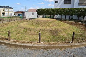
Inaridai Kofun Group
Japanese tomb group
Distance: Approx. 2115 meters
Latitude and longitude: 35.50333333,140.12397222
The Inaridai Kofun Group (稲荷台古墳群) is a Kofun cluster or a group of Kofun located in the Chiba Prefecture.

Ichihara History Museum
Distance: Approx. 2141 meters
Latitude and longitude: 35.504811,140.129304
The Ichihara History Museum (市原歴史博物館, Ichihara Rekishi Hakubutsukan), styled the I'Museum Center, opened in Ichihara, Chiba Prefecture, Japan, in 2022. The collection and displays document thirty thousand years of local history.
Weather in this IP's area
broken clouds
26 Celsius
26 Celsius
25 Celsius
27 Celsius
1016 hPa
77 %
1016 hPa
1016 hPa
10000 meters
1.71 m/s
3.08 m/s
215 degree
54 %
05:23:40
17:44:39