112.135.68.229 - IP Lookup: Free IP Address Lookup, Postal Code Lookup, IP Location Lookup, IP ASN, Public IP
Country:
 Sri Lanka
Region:
City:
Location:
Time Zone:
Postal Code:
ISP:
ASN:
language:
User-Agent:
Proxy IP:
Blacklist:
IP information under different IP Channel
ip-api
Country
Region
City
ASN
Time Zone
ISP
Blacklist
Proxy
Latitude
Longitude
Postal
Route
db-ip
Country
Region
City
ASN
Time Zone
ISP
Blacklist
Proxy
Latitude
Longitude
Postal
Route
IPinfo
Country
Region
City
ASN
Time Zone
ISP
Blacklist
Proxy
Latitude
Longitude
Postal
Route
IP2Location
112.135.68.229Country
lkRegion
sabaragamuwa province
City
ratnapura
Time Zone
Asia/Colombo
ISP
Language
User-Agent
Latitude
Longitude
Postal
ipdata
Country
Region
City
ASN
Time Zone
ISP
Blacklist
Proxy
Latitude
Longitude
Postal
Route
Popular places and events near this IP address
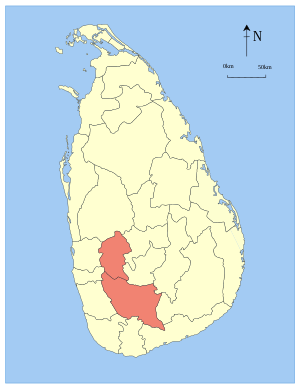
Sabaragamuwa Province
Province of Sri Lanka
Distance: Approx. 1798 meters
Latitude and longitude: 6.66666667,80.4
The Sabaragamuwa Province (Sinhala: සබරගමුව පළාත, romanized: Sabaragamuwa Paḷāta, Tamil: சபரகமுவ மாகாணம், romanized: Sabaragamuva Mākāṇam) is one of the nine provinces of Sri Lanka. Ratnapura is the capital of the province.
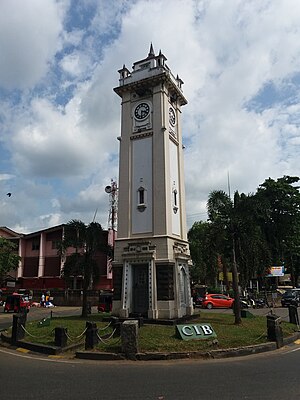
Ratnapura
City in Sabaragamuwa, Sri Lanka
Distance: Approx. 417 meters
Latitude and longitude: 6.68055556,80.40222222
Ratnapura (Sinhala: රත්නපුර; Tamil: இரத்தினபுரி) ("City of Gems" in Sinhala and Tamil) is a major city in Sri Lanka. It is the capital city of Sabaragamuwa Province, as well as the Ratnapura District, and is a traditional centre for the Sri Lankan gem trade. It is located on the Kalu Ganga (Black River) in south-central Sri Lanka, some 101 km (63 mi) southeast of the country's capital, Colombo.

Batugedara
Distance: Approx. 1932 meters
Latitude and longitude: 6.68333333,80.41666667
Batugedara is a small town in the Sabaragamuwa Province of southwestern Sri Lanka, located just to the east of the province's capital of Ratnapura. It is most notable as a source for gemstones, and as a destination for tourism.

Roman Catholic Diocese of Ratnapura
Roman Catholic diocese in Sri Lanka
Distance: Approx. 446 meters
Latitude and longitude: 6.681,80.4028
Roman Catholic Diocese of Ratnapura (Lat: Dioecesis Ratnapurensis) is a diocese of the Latin Church of the Roman Catholic Church in Sri Lanka. Erected as the Diocese of Ratnapura in 1995, from the Diocese of Galle territory, the diocese is suffragan to the Archdiocese of Colombo. The current bishop is Cletus Chandrasiri Perera, appointed in 2007.
Pelwadiya
Village in Sri Lanka
Distance: Approx. 1798 meters
Latitude and longitude: 6.66666667,80.4
Pelwadiya (පැල්වාඩිය) is a village situated in the Sabaragamuwa Province of southwestern Sri Lanka. It is located 5 km (3.1 mi) to the east of the province's capital, Ratnapura.
Sivali Central College
National school in Sri Lanka
Distance: Approx. 3731 meters
Latitude and longitude: 6.71333333,80.38527778
Sivali Central College is a school situated in Hidellana, near Ratnapura, Sabaragamuwa Province, Sri Lanka. The school provides secondary education to boys and girls aged 11 to 19 and has a student population of around 3,500.
Ratnapura Portuguese fort
Distance: Approx. 2351 meters
Latitude and longitude: 6.690866,80.379547
Ratnapura Portuguese fort (Sinhala: රත්නපුර පෘතුගීසි බලකොටුව Rathnapura Pruthugisi Balakotuwa; Tamil: இரத்தினபுரி போர்த்துக்கேயக் கோட்டை, romanized: Irattiṉapuri Pōrttukkēyak Kōṭṭai) was built by the Portuguese in Ratnapura, Sri Lanka. The Portuguese constructed the fort and a church, between 1618 and 1620, on the ground of Saman Devalaya (an ancient devale or Hindu shrine) following the defeat of the King of Sitawaka, Rajasinha I. The town and the fort was later captured by Kirti Sri Raja Singha (the second Nayaka king of Kandy, who destroyed the church and the fort and constructed a Buddhist temple, Maha Saman Devalaya, on the site. In the temple grounds there is a stone sculpture, which depicts the Portuguese General Simao Pinnao, on horseback brandishing a sword, whilst trampling a Sinhalese soldier.

Ratnapura Dutch fort
Distance: Approx. 518 meters
Latitude and longitude: 6.679548,80.402549
Ratnapura Dutch fort, (Sinhala: රත්නපුර ලන්දේසි බලකොටුව Rathnapura Landesi Balakotuwa), was built by the Dutch in Ratnapura, Sri Lanka. The Portuguese had originally constructed a fort at Ratnapura in 1620 however was later captured and destroyed by Kirti Sri Raja Singha (the second Nayaka king of Kandy). By 1658 the Dutch had taken control over all the areas previously controlled by the Portuguese.
National Museum of Ratnapura
National museum in Sri Lanka
Distance: Approx. 179 meters
Latitude and longitude: 6.6844,80.3994
The National Museum of Ratnapura is one of the national museums of Sri Lanka. It is located in Ratnapura, Sri Lanka and it was opened on 13 May 1988. The museum building is called “Ehelepola Walauwa”, as it once belonged to Ehelepola Nilame, a courtier of the Kingdom of Kandy, who was the 1st Adigar (1811 - 1814) under the reign King Sri Vikrama Rajasinha, the last king of Sri Lanka, for whom he served as the Disawe (local Governor) of Ratnapura.

Maha Saman Devalaya
Distance: Approx. 2216 meters
Latitude and longitude: 6.69113889,80.381
Maha Saman Devalaya or the Great Saman Temple (also called Sumana Saman Devalaya) is a shrine dedicated to deity Saman, situated at Ratnapura, Sri Lanka who is the presiding deity of the Sri Pada Mountain which is also called Samanthakuta meaning the mountain of Saman which is believed to have the left foot impression of Buddha which he kept in his visit to Sri Lanka.

St. Aloysius College, Ratnapura
National school in Sri Lanka
Distance: Approx. 454 meters
Latitude and longitude: 6.68138889,80.40305556
St. Aloysius' College (Sinhala: ශාන්ත ඇලෝසියස් විද්යාලය; also referred to as Aloysius College, Ratnapura or simply as Aloysius) is a boys' high school located in Ratnapura, the capital city of Sabaragamuwa Province in Sri Lanka. The school was established in 1898 by Fr: Pierre Boulic.
Ferguson High School, Ratnapura
National school in Ratnapura, Sri Lanka
Distance: Approx. 63 meters
Latitude and longitude: 6.6827135,80.3986365
Ferguson High School (Sinhala: ෆර්ගසන් උසස් විද්යාලය) is a National School in Sri Lanka affiliated with the Sri Lanka Baptist Sangamaya located in Ratnapura District. School has two sections - the Primary section, which serves students from Grade 1 to Grade 5, and the Secondary section, which serves students from Grade 6 to Grade 13.
Weather in this IP's area
overcast clouds
23 Celsius
24 Celsius
23 Celsius
23 Celsius
1012 hPa
94 %
1012 hPa
971 hPa
10000 meters
1.49 m/s
1.57 m/s
105 degree
85 %