Country:
Region:
City:
Latitude and Longitude:
Time Zone:
Postal Code:
IP information under different IP Channel
ip-api
Country
Region
City
ASN
Time Zone
ISP
Blacklist
Proxy
Latitude
Longitude
Postal
Route
Luminati
Country
Region
1
City
negombo
ASN
Time Zone
Asia/Colombo
ISP
Sri Lanka Telecom Internet
Latitude
Longitude
Postal
IPinfo
Country
Region
City
ASN
Time Zone
ISP
Blacklist
Proxy
Latitude
Longitude
Postal
Route
db-ip
Country
Region
City
ASN
Time Zone
ISP
Blacklist
Proxy
Latitude
Longitude
Postal
Route
ipdata
Country
Region
City
ASN
Time Zone
ISP
Blacklist
Proxy
Latitude
Longitude
Postal
Route
Popular places and events near this IP address

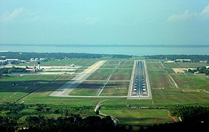
Bandaranaike International Airport
Main airport in Colombo, Sri Lanka
Distance: Approx. 7069 meters
Latitude and longitude: 7.18111111,79.88361111
Bandaranaike International Airport (BIA) (Sinhala: බණ්ඩාරනායක ජාත්යන්තර ගුවන්තොටුපළ, romanized: Bandāranāyaka Jātyantara Guvantoṭupaḷa; Tamil: பண்டாரநாயக்க சர்வதேச விமான நிலையம், romanized: Paṇṭāranāyakka Carvatēca Vimāṉa Nilaiyam) (commonly known as Colombo International Airport, Colombo–Bandaranaike International Airport, and locally as Katunayake International Airport) (IATA: CMB, ICAO: VCBI) is the main international airport in Sri Lanka. It is named after former Prime Minister S. W. R. D. Bandaranaike (1899–1959) and is in the suburb of Negombo, 32.5 kilometres (20+1⁄4 miles) north of the nation's capital and commercial center, Colombo. It is administered by Airport and Aviation Services (Sri Lanka) Ltd and serves as the hub of SriLankan Airlines, the national carrier of Sri Lanka, Fitsair, a privately owned low-cost carrier, and domestic carrier Cinnamon Air.
Bandaranaike Airport attack
2001 suicide bombing by Tamil separatists in Negombo, Sri Lanka
Distance: Approx. 7045 meters
Latitude and longitude: 7.18111111,79.88388889
The Bandaranaike International Airport attack was a suicide raid Black Tigers of the Liberation Tigers of Tamil Eelam (LTTE) on 24 July 2001 on the Sri Lanka Air Force base SLAF Katunayake and the adjoining Bandaranaike International Airport in Katunayake, Sri Lanka. The attack was one of the boldest the LTTE mounted during its war with the Sri Lankan government, and had a profound impact on the country's military, economy, and airline industry.
Minuwangoda
Town in Western Province, Sri Lanka
Distance: Approx. 6444 meters
Latitude and longitude: 7.17333333,79.96194444
Minuwangoda (Sinhala: මිනුවන්ගොඩ, Tamil: மினுவந்கொட) is a town in Gampaha district, governed by an Urban Council, situated near Negombo, Western Province of Sri Lanka. It is located 15 kilometres (9.3 mi) east of Negombo and 35 kilometres (22 mi) north east of Colombo. It is an important junction town, connecting the Negombo to Kandy road (via Veyangoda and Nittambuwa) with the A1/A6 main road from Colombo to Kurunegala.
Kehelella
Village in Western Province, Sri Lanka
Distance: Approx. 7492 meters
Latitude and longitude: 7.26666667,79.98333333
Kehelella is a village in Sri Lanka. It is located within Western Province.
Minuwangoda Divisional Secretariat
Minuwangoda Divisional Secretariat in Western Province, Sri Lanka
Distance: Approx. 6444 meters
Latitude and longitude: 7.17333333,79.96194444
Minuwangoda Divisional Secretariat is a Divisional Secretariat of Gampaha District, of Western Province, Sri Lanka.

Nalanda Boys' Central College
National school in Minuwangoda, Sri Lanka
Distance: Approx. 6311 meters
Latitude and longitude: 7.16972222,79.95161111
Nalanda Boys' Central College – Minuwangoda - Minuwangoda Sinhala: නාලන්දා (පිරිමි) ජාතික පාසල - මිනුවන්ගොඩ was the fourth central college in Sri Lanka, according to a concept of C. W. W. Kannangara. Nalanda College – Minuwangoda is a government Buddhist school in Sri Lanka, and was founded in 1939.
Korase
Village in Western Province, Sri Lanka
Distance: Approx. 6444 meters
Latitude and longitude: 7.17333333,79.96194444
Korase is a small village in Minuwangoda Divisional Secretariat of Sri Lanka.
Dunagaha
Town in Sri Lanka
Distance: Approx. 4599 meters
Latitude and longitude: 7.24222222,79.96861111
Dunagaha (Sinhala: දූනගහ) is a village in Gampaha District of Sri Lanka, with lush green surroundings. It is situated approximately 14 km (8.7 mi) away from Gampaha, 15 km (9.3 mi) from Negombo and in close proximity to suburban areas of Minuwangoda. Paddy and betel cultivation had been the main source of income for many families for decades.

Aluthepola Ganekanda Raja Maha Vihara
Sri Lankan Buddhist temple
Distance: Approx. 3873 meters
Latitude and longitude: 7.20587778,79.96238611
Aluthepola Ganekanda Raja Maha Vihara (Also known as Aluthepola Vihara) (Sinhala: අළුතෑපොල විහාරය) is an old Buddhist temple in Minuwangoda, Sri Lanka. According to the regional folklore this temple is believed to be one of places where King Valagamba spent his time when five Dravidian were ruling Anuradhapura. The temple has been formally recognised by the Government as an archaeological site in Sri Lanka.
Kandawala, Negombo
Suburb in Gampaha, Western Province, Sri Lanka
Distance: Approx. 5850 meters
Latitude and longitude: 7.23722222,79.88083333
Kandawala (Sinhala: කඳවල, romanized: Kan̆davala, Tamil: கந்தவல, romanized: Kantavala) (also known as Kandawala - Negombo and Kandawala - Katana) is a suburb of the city of Negombo, Sri Lanka.

Our Lady of Sorrows Church, Kandawala
Church in Negombo, Sri Lanka
Distance: Approx. 6740 meters
Latitude and longitude: 7.23722222,79.8725
The Church of Our Lady of Sorrows (Sinhala: ශුද්ධවු වික්ෂෝප දේවමාතා දෙව්මැදුර Shudhdhawu Wikshopa Devamatha Dewmædura) (also known as Kandawala Church and Kandawala Palliya (Sinhala: කඳවල පල්ලිය)) is a Roman Catholic church located in Kandawala in the Archdiocese of Colombo, Sri Lanka. Kandawala parish was home to the Church of Our Lady of Sorrows at Kandawala, St. Theresa's Church at Batapattala and Church of Infant Jesus at Demanhandiya.
Walisinghe Harischandra Museum
Biographical museum in Western Province, Sri Lanka
Distance: Approx. 7532 meters
Latitude and longitude: 7.22177778,79.86361111
Brahmachari Walisingha Harischandra Museum (Sinhala: වලිසිංහ හරිශ්චන්ද්ර කෞතුකාගාරය සහ සංස්කෘතික මධ්යස්ථානය) is located in Negombo, Western Province, Sri Lanka. Named after the Buddhist revivalist, social reformer and writer Walisinghe Harischandra (1876-1913). The museum was established in 1996 and is housed in Harischandra's former residence, Mahagedara, which is managed by the Walisinghe Hariswandra Cultural Centre.
Weather in this IP's area
few clouds
25 Celsius
26 Celsius
25 Celsius
25 Celsius
1011 hPa
100 %
1011 hPa
1008 hPa
9000 meters
1.54 m/s
60 degree
20 %
06:01:32
17:48:51