Country:
Region:
City:
Latitude and Longitude:
Time Zone:
Postal Code:
IP information under different IP Channel
ip-api
Country
Region
City
ASN
Time Zone
ISP
Blacklist
Proxy
Latitude
Longitude
Postal
Route
Luminati
Country
ASN
Time Zone
Asia/Seoul
ISP
SamsungSDS Inc.
Latitude
Longitude
Postal
IPinfo
Country
Region
City
ASN
Time Zone
ISP
Blacklist
Proxy
Latitude
Longitude
Postal
Route
db-ip
Country
Region
City
ASN
Time Zone
ISP
Blacklist
Proxy
Latitude
Longitude
Postal
Route
ipdata
Country
Region
City
ASN
Time Zone
ISP
Blacklist
Proxy
Latitude
Longitude
Postal
Route
Popular places and events near this IP address

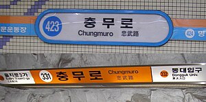
Chungmuro station
Distance: Approx. 438 meters
Latitude and longitude: 37.56130556,126.9945
Chungmuro Station is a station on Line 3 and Line 4 of the Seoul Subway system. Platforms for both Line 3 and Line 4 are located in Chungmuro-4-ga, Jung District, Seoul. This station is named after the road under which it passes, in honor of the Chosun general Yi Sunsin, who was also known by the title of Chungmugong.

Euljiro 3(sam)-ga station
Train station in South Korea
Distance: Approx. 521 meters
Latitude and longitude: 37.56629444,126.99278056
Euljiro 3(sam)-ga (Korean: 을지로3가역) is a station on Line 2 and Line 3 of the Seoul Metropolitan Subway.

Euljiro 4(sa)-ga station
Train station in South Korea
Distance: Approx. 286 meters
Latitude and longitude: 37.56666667,126.99805556
Euljiro 4(sa)-ga is a station on the Line 2 and Line 5 of the Seoul Metropolitan Subway.
Cho-dong
Neighborhood in Seoul, South Korea
Distance: Approx. 530 meters
Latitude and longitude: 37.564,126.992
Cho-dong (Korean: 초동) is a legal dong (neighborhood) of Jung District, Seoul, South Korea. It is governed by its administrative dong, Euljiro 3, 4, 5-dong.

Bangsan Market
Traditional market in Seoul, South Korea
Distance: Approx. 394 meters
Latitude and longitude: 37.5674,126.9996
Bangsan Market (Korean: 방산시장) is a traditional market located in the Jugyo-dong neighborhood of Jung District, Seoul, South Korea. The market is famous for its pressed wrapping paper and includes more than 550 stores. The name of the market comes from the location's former condition during the Joseon Dynasty.
Maeil Broadcasting Network
South Korean cable TV network
Distance: Approx. 610 meters
Latitude and longitude: 37.560475,126.9928191
Maeil Broadcasting Network, Inc. (MBN) (주식회사 매일방송) is a South Korean cable TV network operated by the Maeil Business Newspaper.

Daehan Cinema
Historic movie theater in Seoul, South Korea
Distance: Approx. 405 meters
Latitude and longitude: 37.5611,126.9954
Daehan Cinema (Korean: 대한극장; Hanja: 大韓劇場) is a historic movie theater at Chungmu-ro, Jung District, Seoul, South Korea. It was founded in 1958, and considered one of the premiere theaters in the country until the 1980s. The building has an entrance within the Chungmuro station on lines 3 and 4 of the Seoul Metropolitan Subway.

Taishōkan
1912–1935 movie theater in Korea
Distance: Approx. 353 meters
Latitude and longitude: 37.566,126.9948
Taishōkan (Japanese: 大正館, Korean: 대정관; RR: Daejeonggwan; MR: Taejŏnggwan) was a movie theater in Keijō (Seoul), Korea, Empire of Japan. It operated between 1912 and 1935. It was located at Sakuraicho 1-chōme (櫻井町1丁目; now 26 Inhyeon-dong 1-ga).

Hullyeonwon Park
Park in Seoul, South Korea
Distance: Approx. 624 meters
Latitude and longitude: 37.5673,127.0038
Hullyeonwon Park (Korean: 훈련원공원; Hanja: 訓鍊院公園) is a public park in Jung District, Seoul, South Korea. It was established on June 30, 1997, and has an area of 1.67346 ha (4.1352 acres). The park is named for the Hullyeonwon: the Joseon-era government ministry that oversaw military training.
Woo Lae Oak
Restaurant chain based in Seoul, South Korea
Distance: Approx. 450 meters
Latitude and longitude: 37.5681,126.9987
Woo Lae Oak (Korean: 우래옥; Hanja: 又來屋; RR: Uraeok; lit. place to come back to) is a historic Pyongyang naengmyeon restaurant in Jung District, Seoul, South Korea. It is the oldest active Pyongyang naengmyeon restaurant in Seoul.
Haobin
Fine dining restaurant in Seoul, South Korea
Distance: Approx. 566 meters
Latitude and longitude: 37.5604,127.0024
Haobin (Korean: 호빈; Chinese: 豪賓; lit. 'precious guests') is a fine dining restaurant in Seoul, South Korea. It serves Chinese cuisine.
Andongjang
Historic restaurant in Seoul, South Korea
Distance: Approx. 607 meters
Latitude and longitude: 37.5661,126.9916
Andongjang (Korean: 안동장; Hanja: 安東莊) is a historic Korean-Chinese restaurant in Seoul, South Korea. It is the oldest continually operating Korean Chinese restaurant in the city, having been founded in 1948. It has remained a family business, and is currently on its third generation of owners.
Weather in this IP's area
clear sky
3 Celsius
1 Celsius
3 Celsius
3 Celsius
1033 hPa
65 %
1033 hPa
1028 hPa
10000 meters
2.06 m/s
330 degree
07:16:04
17:19:02