111.92.28.220 - IP Lookup: Free IP Address Lookup, Postal Code Lookup, IP Location Lookup, IP ASN, Public IP
Country:
 India
IndiaRegion:
City:
Location:
Time Zone:
Postal Code:
ISP:
ASN:
language:
User-Agent:
Proxy IP:
Blacklist:
IP information under different IP Channel
ip-api
Country
Region
City
ASN
Time Zone
ISP
Blacklist
Proxy
Latitude
Longitude
Postal
Route
db-ip
Country
Region
City
ASN
Time Zone
ISP
Blacklist
Proxy
Latitude
Longitude
Postal
Route
IPinfo
Country
Region
City
ASN
Time Zone
ISP
Blacklist
Proxy
Latitude
Longitude
Postal
Route
IP2Location
111.92.28.220Country
inRegion
kerala
City
paravur
Time Zone
Asia/Kolkata
ISP
Language
User-Agent
Latitude
Longitude
Postal
ipdata
Country
Region
City
ASN
Time Zone
ISP
Blacklist
Proxy
Latitude
Longitude
Postal
Route
Popular places and events near this IP address

Varkala
Town in Kerala, India
Distance: Approx. 4466 meters
Latitude and longitude: 8.7432986,76.6968401
Varkala is a major coastal municipality and a northern suburb of Thiruvananthapuram, the capital city of the Indian state of Kerala. In legends and myths related to Kerala, texts like the Kerala Mahatmyam describe the Varkala region as one of the sacred places of Kerala. Varkala is the only region in southern Kerala where cliffs are found adjacent to the Arabian Sea.

Paravur, Kollam
Municipal Town in Kerala, India
Distance: Approx. 4598 meters
Latitude and longitude: 8.811,76.669
Paravur (Malayalam pronunciation: [pɐɾɐʋuːr]) is a municipality in the Kollam district of Kerala, India. Paravur is located 11.6 km (7.2 mi) southeast of the Kollam city centre, and is a part of the Kollam metropolitan area. Paravur railway station is the last station in Kollam district which is on the route to Trivandrum while travelling towards South India.

Madhuca diplostemon
Species of tree
Distance: Approx. 4380 meters
Latitude and longitude: 8.81731,76.67998
Madhuca diplostemon is a species of flowering plant in the family Sapotaceae, endemic to India. It is a threatened tree species of the Western Ghats whose original specimens were collected in 1835, and it was considered extinct for 184 years until a single living specimen was discovered in a sacred grove in Kollam district, when scientists at the Jawaharlal Nehru Tropical Botanic Garden and Research Institute (JNTBGRI) identified the tree as Madhuca diplostemon rather than the common attilippa (Madhuca neriifolia). The lone mature tree is located at the Koonayil Ayiravilli Shiva temple at Paravur, Kollam, Kerala.
Poothakkulam
Village in Kerala, India
Distance: Approx. 3518 meters
Latitude and longitude: 8.8111,76.7152
Poothakkulam, also known as Bhoothakkulam, is a village in Kollam district in the state of Kerala, India. The village is located 3.9 km away from Paravur, 11.4 km from Varkala and 23 km from Kollam. In 2011, it had a population of 628,451 residents.

Edava
Village in Kerala, India
Distance: Approx. 2107 meters
Latitude and longitude: 8.7671,76.6901
Edava is a panchayat in Varkala Taluk, which is the northernmost tip of Thiruvananthapuram district in the state of Kerala, India. Edava is located 5km north of Varkala, 21km south of port city Kollam and 44km north of capital city Thiruvananthapuram. Kappil beach is a famous surf location.
Kappil, Thiruvananthapuram
Village in Thiruvananthapuram district, Kerala
Distance: Approx. 2619 meters
Latitude and longitude: 8.78027778,76.67638889
Kappil is a seashore tourist spot located in Thiruvananthapuram district, Kerala, India. Varkala railway station is the major railway station near Kappil.

Palakkavu Bhagavathi Temple
Hindu temple in Kerala, India
Distance: Approx. 2345 meters
Latitude and longitude: 8.765,76.68944444
The Edava Palakkavu Bhagavathi temple (ഇടവാ പാലക്കാവ് ഭഗവതി ക്ഷേത്രം) is one of the ancient temples in south India. It is situated at Edava in Thiruvananthapuram District, India. The temple is situated 5.7km North of Varkala City.Bhadrakali Devi is the presiding deity of this temple.

Thekkumbhagam
Neighbourhood in Kollam, Kerala, India
Distance: Approx. 3982 meters
Latitude and longitude: 8.798,76.667
Thekkumbhagam or Thekkumbhagom is the western coastal town of Paravur municipality in the Kollam district of Kerala, India. It is located at the South-western tip of Kollam's coastal area. It is in the Arabian Sea coast.
Kottappuram, Paravur
Neighbourhood & Urban Village in Kollam, Kerala, India
Distance: Approx. 4158 meters
Latitude and longitude: 8.806022,76.670004
Kottappuram or Kottapuram is an urban village, situated at Paravur municipality in Kollam district, Kerala. It is one among the two villages in Paravur municipality and one among the 30 villages coming under Kollam Taluk. Kottapuram is situated in between Paravur town and Paravur Thekkumbhagam.
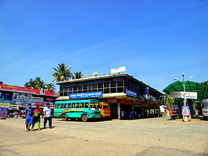
Paravur Municipal Bus Stand
Distance: Approx. 4645 meters
Latitude and longitude: 8.81121389,76.66861389
Paravur Municipal Bus Stand or Paravur Private Bus Stand is the one and only bus stand in Paravur municipal town of Kollam district, Kerala. The bus stand construction project was implemented by the Municipal council of Paravur before some years.

Nehru Park, Paravur
Distance: Approx. 4691 meters
Latitude and longitude: 8.814191,76.670997
Nehru Park or Children's Park, Paravur (also known as Paravur Municipal Park) is a public park situated at Paravur in Kollam Metropolitan Area, India. It is situated very close to Paravur railway station. Nehru Park is one of the main centres of recreational activities in Paravur town.

Kurakkanni
Neighbourhood in Thiruvananthapuram, Kerala, India
Distance: Approx. 4437 meters
Latitude and longitude: 8.74392,76.7062
Kurakkanni is the north western area of Varkala Town in Varkala Municipality of Trivandrum district in the state of Kerala, India. It is one of the fastest growing commercial-residential area of Varkala town situated 3.6 km (2.2 mi) from the town centre, 25 km (16 mi) south of Kollam City, 43 km (27 mi) north of Trivandrum City along Trivandrum - Varkala - Kollam coastal highway road. Varkala Helipad, Govt Guest House, Varkala Palace, Varkala Aquarium, Varkala Hatchery and the National Centre for Performing Arts are located in Kurakkanni.
Weather in this IP's area
clear sky
23 Celsius
24 Celsius
23 Celsius
23 Celsius
1011 hPa
90 %
1011 hPa
1010 hPa
10000 meters
1.9 m/s
1.71 m/s
59 degree
8 %