111.92.120.69 - IP Lookup: Free IP Address Lookup, Postal Code Lookup, IP Location Lookup, IP ASN, Public IP
Country:
 India
IndiaRegion:
City:
Location:
Time Zone:
Postal Code:
ISP:
ASN:
language:
User-Agent:
Proxy IP:
Blacklist:
IP information under different IP Channel
ip-api
Country
Region
City
ASN
Time Zone
ISP
Blacklist
Proxy
Latitude
Longitude
Postal
Route
db-ip
Country
Region
City
ASN
Time Zone
ISP
Blacklist
Proxy
Latitude
Longitude
Postal
Route
IPinfo
Country
Region
City
ASN
Time Zone
ISP
Blacklist
Proxy
Latitude
Longitude
Postal
Route
IP2Location
111.92.120.69Country
inRegion
kerala
City
thrissur
Time Zone
Asia/Kolkata
ISP
Language
User-Agent
Latitude
Longitude
Postal
ipdata
Country
Region
City
ASN
Time Zone
ISP
Blacklist
Proxy
Latitude
Longitude
Postal
Route
Popular places and events near this IP address

St. Thomas College, Thrissur
College in Thrissur, Kerala
Distance: Approx. 726 meters
Latitude and longitude: 10.52301,76.21942
St. Thomas College (Autonomous), Thrissur, is a government aided catholic college located in Thrissur, Kerala, India. Established as a college in 1918, the college is considered to be one of the oldest and premier instituitions of higher education in Princely State of Cochin.

Thrissur district
District in Kerala, India
Distance: Approx. 885 meters
Latitude and longitude: 10.52,76.21
Thrissur (Malayalam: [t̪riʃ(ː)uːr] ), anglicised as Trichur, is one of the 14 districts in the Indian state of Kerala. It is situated in the central region of the state. Spanning an area of about 3,032 km2 (1,171 sq mi), the district is home to over 9% of Kerala's population.

Sakthan Thampuran Nagar
CBD in Kerala, India
Distance: Approx. 342 meters
Latitude and longitude: 10.5141,76.2159
Sakthan Thampuran Nagar (S.T Nagar) is one of the business districts of Thrissur city in Kerala state, South India. It was named after King of the Cochin, Sakthan Thampuran, the very architect of Thrissur.
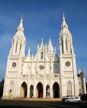
Basilica of Our Lady of Dolours, Thrissur
Church in Kerala, India
Distance: Approx. 472 meters
Latitude and longitude: 10.521,76.218
Our Lady of Dolours Basilica alias Puthenpally (Malayalam: പുത്തൻപള്ളി, meaning: New Church) is a minor basilica of the Syro-Malabar Catholic Church in Thrissur City in Kerala, India. The tallest church in India and the third tallest in Asia, it is famous for its Gothic style architecture. Built in fine Indo-Gothic style with an area of 25,000 square feet (2,300 m2), it has soaring belfries at the entrance, double-storeyed aisles all along the nave and transepts, and eleven altars, five on either side of the main one.

Paramekkavu Bagavathi Temple
Hindu temple in Kerala, India
Distance: Approx. 881 meters
Latitude and longitude: 10.5247,76.2178
Paramekkavu Bagavathi Temple is one of the largest Bagavathi temples in Kerala located in Thrissur City. Sakthan Thampuran ordained the temples into two groups, namely "Paramekkavu side" and "Thiruvambady side" for Thrissur Pooram which is the biggest festival in South India and Kerala. These two groups are headed by the principal participants, Paramekkavu Bagavathi Temple at Thrissur Swaraj Round and Thiruvambadi Sri Krishna Temple at Shoranur road.

Chaldean Syrian Higher Secondary School, Thrissur
School in Kerala, India
Distance: Approx. 200 meters
Latitude and longitude: 10.5185,76.218
Chaldean Syrian Higher Secondary School (Malayalam: കാൽഡിയൻ സിറിയൻ ഹയർസെക്കൻഡറി സ്കൂൾ) is an English language secondary school in Thrissur, Kerala, India. It was established in 1927. The school's current principal is Dr.
Kerala University of Health Sciences
State university located in Thrissur, Kerala, India
Distance: Approx. 713 meters
Latitude and longitude: 10.5232,76.2171
Kerala University of Health Sciences (KUHS) is a state university located in Thrissur, Kerala, India. It was established by the Kerala University of Health Sciences Act 2010, for ensuring proper and systematic instruction, teaching, training, and research and also to have uniformity in the various academic programmes in medical and allied subjects in the State of Kerala. The University is mandated to affiliate all Colleges and Institutions in Kerala, imparting professional education in health care.
Trichur Heart Hospital
Hospital in Kerala, India
Distance: Approx. 535 meters
Latitude and longitude: 10.51277778,76.21472222
Trichur Heart Hospital is a 500-bed speciality hospital situated in Thrissur, Kerala, India. The hospital is equipped with most modern cardiac catheterisation lab ensuring detailed study of chambers, valves, coronary arteries, and blood flow details. The hospital specializes in neurology, general medicine, general surgery, orthopedics, gynecology, anaesthesiology, neonatology, pathology and histopathology, dermatology and physiotherapy.

Marth Mariam Cathedral
Church in Thrissur, India
Distance: Approx. 172 meters
Latitude and longitude: 10.51833333,76.21722222
Marth Mariam Cathedral is the cathedral of the Chaldean Syrian Church of India, part of the Assyrian Church of the East. It is located in Thrissur City in the state of Kerala, India. It is the city's first Christian church inside the fort gates and is the fourth church in the Thrissur Municipal Corporation The church established in 1814 by Sakthan Thampuran, the maharajah of Cochin, for the Chaldaya Suriyani Nasrani (Ancient Indian Christian community) whom he invited to live in Thrissur to strengthen the trade sector of the new city.

Thekkinkadu Maidan
Distance: Approx. 960 meters
Latitude and longitude: 10.5249,76.2144
Thekkinkadu Maidanam is a historic open ground located in the center of Thrissur city in the Kerala state of India. The 65-acre area surrounds the ancient Vadakkunnathan Temple, one of the most significant Shiva temples in Kerala, and is a vital cultural and historical landmark.

Thrissur KSRTC bus station
Distance: Approx. 767 meters
Latitude and longitude: 10.51753,76.210431
Thrissur KSRTC bus station is a state-owned Kerala State Road Transport Corporation (KSRTC) bus station in Kokkalai in the heart of the Thrissur City, India. The bus station is very near to the Thrissur railway station.
Academy of Sharia and Advanced Studies
Higher education school in Thrissur, Kerala, India
Distance: Approx. 688 meters
Latitude and longitude: 10.5120683,76.21335357
The Academy of Sharia and Advanced Studies (ASAS), run by Malik Bin Deenar Islamic Complex, located in Thrissur, is the first Islamic institute to include Sanskrit in its syllabus. Teaching Sanskrit, also known as "Deva Bhasa," to its students with the help of Hindu Scholars. As part of including Sanskrit, here important portions of the Bhagavad Gita, Upanishads, Mahabharata, and Ramayana are selectively taught.
Weather in this IP's area
scattered clouds
20 Celsius
21 Celsius
20 Celsius
20 Celsius
1011 hPa
97 %
1011 hPa
1008 hPa
10000 meters
1.52 m/s
1.47 m/s
49 degree
29 %