Country:
 Thailand
Region:
City:
Latitude and Longitude:
Time Zone:
Postal Code:
IP information under different IP Channel
ip-api
Country
Region
City
ASN
Time Zone
ISP
Blacklist
Proxy
Latitude
Longitude
Postal
Route
IPinfo
Country
Region
City
ASN
Time Zone
ISP
Blacklist
Proxy
Latitude
Longitude
Postal
Route
MaxMind
Country
Region
City
ASN
Time Zone
ISP
Blacklist
Proxy
Latitude
Longitude
Postal
Route
Luminati
Country
THASN
Time Zone
Asia/Bangkok
ISP
26th Floor 3333 Moo 14 Chai Building
Latitude
Longitude
Postal
db-ip
Country
Region
City
ASN
Time Zone
ISP
Blacklist
Proxy
Latitude
Longitude
Postal
Route
ipdata
Country
Region
City
ASN
Time Zone
ISP
Blacklist
Proxy
Latitude
Longitude
Postal
Route
Popular places and events near this IP address

Queen Saovabha Memorial Institute
Distance: Approx. 297 meters
Latitude and longitude: 13.73231667,100.5327
The Queen Saovabha Memorial Institute (QSMI) (Thai: สถานเสาวภา; RTGS: Sathan Saowapha) in Bangkok, Thailand, is an institute that specialises in the husbandry of venomous snakes, the extraction and research of snake venom, and vaccines, especially rabies vaccine. It houses the snake farm, a popular tourist attraction. The origins of the institute can be traced back to 1912 when King Rama VI granted permission for a government institute to manufacture and distribute rabies vaccine at the suggestion of Prince Damrong, whose daughter, Princess Banlusirisarn, died from rabies infection.

Bangkok Christian Hospital
Hospital in Bangkok, Thailand
Distance: Approx. 512 meters
Latitude and longitude: 13.72833333,100.53111111
The Bangkok Christian Hospital (Thai: โรงพยาบาลกรุงเทพคริสเตียน) is one of the oldest general hospitals in Bangkok, Thailand. Situated on Silom Road, Bang Rak District.

Museum of Imagery Technology
Distance: Approx. 480 meters
Latitude and longitude: 13.737103,100.529655
Museum of Imaging Technology is a museum in Pathum Wan District, Bangkok, Thailand. It is located in Faculty of Science, Chulalongkorn University.

Chamchuri Square
Commercial office, retail, residential in Bangkok, Thailand
Distance: Approx. 60 meters
Latitude and longitude: 13.73277778,100.53055556
Chamchuri Square is a high-rise building complex located in Bangkok, Thailand. It consists of a commercial office tower, a residential tower and a podium housing a shopping mall which connects the two. Owned by Chulalongkorn University, construction on the complex began in 1994 but was halted from 1996 to 2005 and later completed in 2008.

Sam Yan
Road junction
Distance: Approx. 150 meters
Latitude and longitude: 13.73277778,100.52861111
Sam Yan (Thai: สามย่าน, pronounced [sǎːm jâːn]) is the name of an intersection and its nearby neighbourhood in Bangkok, Thailand. It connects Rama IV Road with Phaya Thai and Si Phraya roads, and is located within Pathum Wan District, next to its border with Bang Rak. The neighbourhood lies in the intersection's northwest corner on land owned by Chulalongkorn University, and is famous for its restaurants.

Soi Pratuchai
Distance: Approx. 330 meters
Latitude and longitude: 13.730443,100.5318478
Soi Pratuchai (alias: "Soi Twilight"; Thai: ซอยประตูชัย, meaning "Triumphal arch soi") was walkway ("soi") in the Bangrak district of Bangkok, Thailand known for being a gay-related entertainment district, catering mainly, though not exclusively, to foreign tourists and expatriates. While Soi Pratuchai was internationally known as a red light district for gays at the heart of Bangkok's sex industry, the city in fact has numerous gay-related red-light districts that are far more popular with Thai. Soi Pratuchai was closed since 1 April 2019 with its land plots being bought.

Wat Hua Lamphong
Distance: Approx. 131 meters
Latitude and longitude: 13.73194444,100.52916667
Wat Hua Lamphong (Thai: วัดหัวลำโพง, pronounced [wát hǔa.lām.pʰōːŋ]) is a Royal Buddhist temple, third class, in the Bang Rak District of Bangkok, Thailand. It is located on Rama IV Road, with Si Lom Road and Suriwong Road in Bangkok's modern business district to the southeast, and Si Phraya Road to the northwest. It is a block from The Montien hotel, and approximately 1 km from the city's main Hua Lamphong railway station.
Chulalongkorn Business Academic and Coaching Center
Training center in Bangkok, Thailand
Distance: Approx. 180 meters
Latitude and longitude: 13.734381,100.530369
Chulalongkorn Business Academic and Coaching Center (CBAC; Thai: ศูนย์ฝึกอบรมด้านธุรกิจของคณะพาณิชยศาสตร์และการบัญชี จุฬาลงกรณ์มหาวิทยาลัย) is a training and coaching center in Thailand. It was founded in 1995 by Chulalongkorn Business Administration (CBA), as Micro MBA Chula, in order to provide multiple business courses for Thai people.

Rama IV Road
Road in Thailand
Distance: Approx. 517 meters
Latitude and longitude: 13.73056667,100.53419444
Rama IV Road (Thai: ถนนพระรามที่ 4, RTGS: Thanon Phra Ram Thi Si; usually shortened to ถนนพระราม 4, RTGS: Thanon Phra Ram Si) is a main road in Bangkok, Thailand. It starts at Mo Mi Junction in the area of Bangkok's Chinatown in Samphanthawong and Pom Prap Sattru Phai Districts and ends at the junction with Sukhumvit Road (Phra Khanong Junction) in Khlong Toei District near Bangkok Port, also known as Khlong Toei Port. Bordering the road are the Hua Lamphong railway station, Wat Hua Lamphong, New Sam Yan Market, Lumphini Park and Rama VI Memorial Plaza, King Chulalongkorn Memorial Hospital and Queen Saovabha Memorial Institute, the Metropolitan Electricity Authority, and the headquarters of Channel 3.
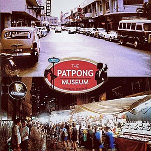
Patpong Museum
Private museum dedicated to the history of Bangkok's Patpong red-light district
Distance: Approx. 509 meters
Latitude and longitude: 13.728736,100.532163
The Patpong Museum is a museum in Bangkok, Thailand. Opened in 2019 in Patpong Soi 2, its collection includes interactive exhibitions, artifacts, and recreated spaces covering Patpong's history from its 1946 purchase by the Luang Patpongpanich and subsequent development. The presence of the CIA in Patpong through its secret airlines such as "Civil Air Transport" and "Air America" is highlighted and brings the cold war, the Vietnam war and the secret war in Laos into the context of Patpong.

Samyan Mitrtown
Shopping mall in Bangkok, Thailand
Distance: Approx. 236 meters
Latitude and longitude: 13.73416667,100.52833333
Samyan Mitrtown (Thai: สามย่านมิตรทาวน์) is a mixed-use shopping, office, residential and leisure development located in Bangkok, Thailand. With a gross floor area of 222,000 square metres (2,390,000 sq ft), the ฿9 billion complex comprises Samyan Mitrtown Mall, Mitrtown Office Tower, Triple Y Residence and Triple Y Hotel.

Patpong Night Market
Night market in Bangkok, Thailand
Distance: Approx. 500 meters
Latitude and longitude: 13.72868,100.53183
Patpong Night Market is a night bazaar in well-known red-light district Patpong neighbourhood in downtown Bangkok. Patpong is a popular entertainment district located in the namesake soi (alley) of Silom road. One of the most important commercial zones of Bangkok.
Weather in this IP's area
overcast clouds
28 Celsius
31 Celsius
28 Celsius
28 Celsius
1004 hPa
76 %
1004 hPa
1003 hPa
10000 meters
4.17 m/s
10.83 m/s
272 degree
100 %
06:06:54
18:18:02