111.217.103.41 - IP Lookup: Free IP Address Lookup, Postal Code Lookup, IP Location Lookup, IP ASN, Public IP
Country:
 Japan
JapanRegion:
City:
Location:
Time Zone:
Postal Code:
ISP:
ASN:
language:
User-Agent:
Proxy IP:
Blacklist:
IP information under different IP Channel
ip-api
Country
Region
City
ASN
Time Zone
ISP
Blacklist
Proxy
Latitude
Longitude
Postal
Route
db-ip
Country
Region
City
ASN
Time Zone
ISP
Blacklist
Proxy
Latitude
Longitude
Postal
Route
IPinfo
Country
Region
City
ASN
Time Zone
ISP
Blacklist
Proxy
Latitude
Longitude
Postal
Route
IP2Location
111.217.103.41Country
jpRegion
shizuoka
City
hamamatsu
Time Zone
Asia/Tokyo
ISP
Language
User-Agent
Latitude
Longitude
Postal
ipdata
Country
Region
City
ASN
Time Zone
ISP
Blacklist
Proxy
Latitude
Longitude
Postal
Route
Popular places and events near this IP address

Hamamatsu
City in Shizuoka prefecture, Japan
Distance: Approx. 165 meters
Latitude and longitude: 34.71083333,137.7275
Hamamatsu (浜松市, Hamamatsu-shi) is a city located in western Shizuoka Prefecture, Japan. In September 2023, the city had an estimated population of 780,128 in 340,591 households, making it the prefecture's largest city, with a population density of 500/km2 (1,300/sq mi) over the total urban area of 1,558.06 km2 (601.57 sq mi).
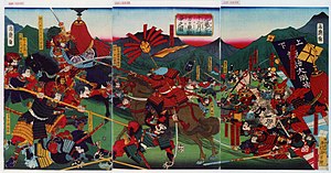
Battle of Mikatagahara
1573 battle in Japan
Distance: Approx. 604 meters
Latitude and longitude: 34.71,137.71916667
The Battle of Mikatagahara (三方ヶ原の戦い, Mikatagahara no tatakai) took place during the Sengoku period of Japan between Takeda Shingen and Tokugawa Ieyasu in Mikatagahara, Tōtōmi Province on 25 January 1573. Shingen attacked Ieyasu at the plain of Mikatagahara north of Hamamatsu during his campaign against Oda Nobunaga while seeking a route from Kōfu to Kyoto. The Tokugawa-Oda force was almost totally annihilated by the Takeda after being encircled and many of Ieyasu's retainers were killed in the battle.

Hamamatsu Station
Railway station in Hamamatsu, Japan
Distance: Approx. 1132 meters
Latitude and longitude: 34.70361111,137.73444444
Hamamatsu Station (浜松駅, Hamamatsu-eki) is a railway station on the Tōkaidō Main Line and the Tōkaidō Shinkansen in Hamamatsu, Shizuoka, Japan, operated by the Central Japan Railway Company (JR Central). The local Enshū Railway Line terminus of Shin-Hamamatsu Station is 3 minutes' walking distance away.

Hamamatsu Castle
Distance: Approx. 131 meters
Latitude and longitude: 34.711802,137.724958
Hamamatsu Castle (浜松城, Hamamatsu-jō) is a hirayama-style Japanese castle ruin, with some replica castle buildings. It was the seat of various fudai daimyō who ruled over Hamamatsu Domain, Tōtōmi Province, in what is now central Hamamatsu, Shizuoka Prefecture, Japan under the Edo period Tokugawa shogunate. It is also called Shusse Castle (出世城, Shusse-jō).

Shin-Hamamatsu Station
Railway station in Hamamatsu, Japan
Distance: Approx. 997 meters
Latitude and longitude: 34.70371944,137.73237778
Shin-Hamamatsu Station (新浜松駅, Shin-Hamamatsu-eki) is a railway station in Chūō-ku, Hamamatsu, Shizuoka Prefecture, Japan, operated by the private railway company, Enshū Railway.
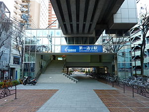
Daiichidōri Station
Railway station in Hamamatsu, Japan
Distance: Approx. 751 meters
Latitude and longitude: 34.70723889,137.73267222
Daiichidōri Station (第一通り駅, Daiichidōri-eki) is a railway station in Chūō-ku, Hamamatsu, Shizuoka Prefecture, Japan, operated by the private railway company, Enshū Railway.

Enshūbyōin Station
Railway station in Hamamatsu, Japan
Distance: Approx. 696 meters
Latitude and longitude: 34.71063333,137.73330278
Enshūbyōin Station (遠州病院駅, Enshūbyōin-eki) is a railway station in Chūō-ku, Hamamatsu, Shizuoka Prefecture, Japan, operated by the private railway company, Enshū Railway.

Naka-ku, Hamamatsu
Ward in Chūbu, Japan
Distance: Approx. 35 meters
Latitude and longitude: 34.71080556,137.72608333
Naka-ku (中区, Naka-ku) was a ward in Hamamatsu, Shizuoka, Japan, located in the central part of the city. It encompasses the site of Hamamatsu Castle and Hamamatsu Station, the central business district and a number of high density residential areas. Although its area is the smallest of the seven wards of Hamamatsu, it has the largest population.

Act Tower
Skyscraper in Japan
Distance: Approx. 1116 meters
Latitude and longitude: 34.70505556,137.73569444
Act Tower (アクトシティ浜松) is a skyscraper in Hamamatsu, Shizuoka Prefecture, Japan. It is 213 metres (699 ft) tall, and has 45 floors, making it the tallest building in Shizuoka Prefecture. It was constructed in 1994, and houses the Okura City Hotel in its top 17 floors, as well as observation deck on its top floor.

Hamamatsu Municipal Senior High School
School in Hamamatsu, Japan
Distance: Approx. 927 meters
Latitude and longitude: 34.7164,137.7182
Hamamatsu Municipal Senior High School (浜松市立高等学校, Hamamatsu-shiritsu Kōtōgakkō) is a senior high school in Hamamatsu, Japan, operated by the city government. Because the city of Hamamatsu has one of the largest non-Japanese populations in the country, 60% of which is composed of expatriates of Brazilian descent. there is a significant enrollment of students who do not speak Japanese as a primary language.
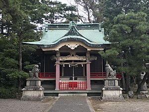
Motoshirochō Tōshō-gū
Distance: Approx. 365 meters
Latitude and longitude: 34.713142,137.728486
Motoshirochō Tōshō-gū (元城町東照宮, Motoshirochō Tōshō-gū) is a Shinto shrine in Chūō-ku, Hamamatsu, Shizuoka Prefecture, Japan. It was established in 1886, and its main festival is held annually on October 10.
Chūō-ku, Hamamatsu
Ward in Chūbu, Japan
Distance: Approx. 35 meters
Latitude and longitude: 34.71080556,137.72608333
Chūō-ku (中央区, Chūō-ku) is one of the three wards of Hamamatsu, Shizuoka, Japan, located in the south part of the city. It will encompass the site of Hamamatsu Castle, Lake Hamana and Hamamatsu Station, the central business and residential district. Although its area will be the smallest of the three wards of Hamamatsu, it will have by far the largest population.
Weather in this IP's area
clear sky
2 Celsius
-2 Celsius
2 Celsius
2 Celsius
1019 hPa
74 %
1019 hPa
1017 hPa
10000 meters
3.13 m/s
5.36 m/s
322 degree
6 %