111.119.37.212 - IP Lookup: Free IP Address Lookup, Postal Code Lookup, IP Location Lookup, IP ASN, Public IP
Country:
Region:
City:
Location:
Time Zone:
Postal Code:
IP information under different IP Channel
ip-api
Country
Region
City
ASN
Time Zone
ISP
Blacklist
Proxy
Latitude
Longitude
Postal
Route
Luminati
Country
Region
p5
City
ghorahi
ASN
Time Zone
Asia/Kathmandu
ISP
Websurfer Nepal Internet Service Provider
Latitude
Longitude
Postal
IPinfo
Country
Region
City
ASN
Time Zone
ISP
Blacklist
Proxy
Latitude
Longitude
Postal
Route
IP2Location
111.119.37.212Country
Region
koshi
City
ilam
Time Zone
ISP
Language
User-Agent
Latitude
Longitude
Postal
db-ip
Country
Region
City
ASN
Time Zone
ISP
Blacklist
Proxy
Latitude
Longitude
Postal
Route
ipdata
Country
Region
City
ASN
Time Zone
ISP
Blacklist
Proxy
Latitude
Longitude
Postal
Route
Popular places and events near this IP address

Ilam District
District in Koshi Province, Nepal
Distance: Approx. 1164 meters
Latitude and longitude: 26.9,87.93333333
Ilam district (Nepali: इलाम जिल्ला) is one of 14 districts of Koshi Province of eastern Nepal. It is a Hill district and covers 1,703 km2 (658 sq mi). The 2011 census counted 290,254 inhabitants.

Ilam Municipality
Municipality in Koshi Province, Nepal
Distance: Approx. 215 meters
Latitude and longitude: 26.90833333,87.92638889
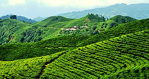
Ilam (Nepali: इलाम ) is one of four urban municipalities of Ilam District, which lies in the Mahabharata hilly range of Koshi Province, eastern Nepal. Ilam also acts as the headquarters of Ilam District. Being the largest producer region for Nepali tea, its tea farms are a major tourist attraction in Koshi Province.
Barbote
Village Development Committee in Province No. 1, Nepal
Distance: Approx. 4523 meters
Latitude and longitude: 26.95,87.93
Barbote was a town and Village Development Committee in Ilam District in the Province No. 1 of eastern Nepal. At the time of the 1991 Nepal census it had a population of 4,739 persons living in 876 individual households.
Godak
Village Development Committee in Province No. 1, Nepal
Distance: Approx. 5285 meters
Latitude and longitude: 26.88,87.97
Godak is a town and Village Development Committee in Ilam District in the Province No. 1 of eastern Nepal. At the time of the 1991 Nepal census it had a population of 3,448 persons living in 646 individual households.

Lakshmipur, Ilam
Village Development Committee in Province No. 1, Nepal
Distance: Approx. 8584 meters
Latitude and longitude: 26.85,87.98333333
Laxmipur is a town and former Village Development Committee in Ilam District in the Province No. 1 of eastern Nepal. Previously when Laxmipur was still a Village Development Committee it consisted of a total of nine numbered wards.
Namsaling
Village Development Committee in Province No. 1, Nepal
Distance: Approx. 6247 meters
Latitude and longitude: 26.92,87.99
Namsaling is a town and Village Development Committee in Ilam District in the Province No. 1 of eastern Nepal. At the time of the 1991 Nepal census it had a population of 4,978 persons living in 905 individual households.
Shantidanda
Village Development Committee in Province No. 1, Nepal
Distance: Approx. 2914 meters
Latitude and longitude: 26.91666667,87.9
Shantidanda is a town and Village Development Committee in Ilam District in the Province No. 1 of eastern Nepal. At the time of the 1991 Nepal census it had a population of 4,373 persons living in 794 individual households.
Soyang
Village Development Committee in Province No. 1, Nepal
Distance: Approx. 6845 meters
Latitude and longitude: 26.95,87.98
Soyang is a town and Village Development Committee in Ilam District in the Province No. 1 of eastern Nepal. At the time of the 1991 Nepal census it had a population of 3,197 persons living in 740 individual households.
Sumbek
Village Development Committee in Province No. 1, Nepal
Distance: Approx. 8151 meters
Latitude and longitude: 26.98,87.95
Sumbek is a town and Village Development Committee in Ilam District in the Province No. 1 of eastern Nepal. At the time of the 1991 Nepal census it had a population of 2,228 persons living in 388 individual households.
Dhulabari
Place in Province No. 1, Nepal
Distance: Approx. 7097 meters
Latitude and longitude: 26.95,87.98333333
Dhulabari is a town in Jhapa District in the Province No. 1 of south-eastern Nepal. It is part of Mechinagar Municipality.

Puwa River
River
Distance: Approx. 5784 meters
Latitude and longitude: 26.859383,87.912407
The Puwa River (or Puwa Khola) is a river in Nepal. It is a right tributary of the Mai Khola.
Sukilumba Airport
Airport
Distance: Approx. 4222 meters
Latitude and longitude: 26.87752183,87.90515383
Sukilumba Airport (IATA: —, ICAO: —), also known as Ilam Airport, is a domestic airport located in Ilam serving Ilam District, a district in Koshi Province in Nepal. Flight time from Kathmandu to Sukilumba Airport is about one hour.
Weather in this IP's area
few clouds
17 Celsius
16 Celsius
17 Celsius
17 Celsius
1018 hPa
51 %
1018 hPa
888 hPa
10000 meters
2.97 m/s
2.1 m/s
184 degree
11 %