110.76.183.5 - IP Lookup: Free IP Address Lookup, Postal Code Lookup, IP Location Lookup, IP ASN, Public IP
Country:
Region:
City:
Location:
Time Zone:
Postal Code:
IP information under different IP Channel
ip-api
Country
Region
City
ASN
Time Zone
ISP
Blacklist
Proxy
Latitude
Longitude
Postal
Route
Luminati
Country
ASN
Time Zone
Asia/Tokyo
ISP
MBO holdings Inc.
Latitude
Longitude
Postal
IPinfo
Country
Region
City
ASN
Time Zone
ISP
Blacklist
Proxy
Latitude
Longitude
Postal
Route
IP2Location
110.76.183.5Country
Region
nagasaki
City
nagasaki
Time Zone
Asia/Tokyo
ISP
Language
User-Agent
Latitude
Longitude
Postal
db-ip
Country
Region
City
ASN
Time Zone
ISP
Blacklist
Proxy
Latitude
Longitude
Postal
Route
ipdata
Country
Region
City
ASN
Time Zone
ISP
Blacklist
Proxy
Latitude
Longitude
Postal
Route
Popular places and events near this IP address

Urakami
Area in the city of Nagasaki
Distance: Approx. 1091 meters
Latitude and longitude: 32.773753,129.863251
Urakami was an area in the northern part of the city of Nagasaki, Japan.

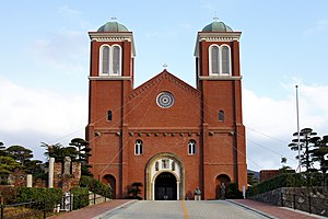
Immaculate Conception Cathedral, Nagasaki
Church in Nagasaki, Japan
Distance: Approx. 767 meters
Latitude and longitude: 32.77619444,129.86838889
The Immaculate Conception Cathedral (無原罪の聖母司教座聖堂) also St. Mary's Cathedral, often known as Urakami Cathedral (Japanese: 浦上天主堂, romanized: Urakami Tenshudō) after its location Urakami, is a Roman Catholic cathedral located in Motoomachi, Nagasaki, Japan.

Nagasaki Peace Park
Park located in Nagasaki, Japan
Distance: Approx. 891 meters
Latitude and longitude: 32.7757,129.8632
Nagasaki Peace Park is a park located in Nagasaki, Japan, commemorating the atomic bombing of the city on August 9, 1945 during World War II. It is next to the Atomic Bomb Museum and near the Peace Memorial Hall.

Nagasaki University
National university of Japan
Distance: Approx. 353 meters
Latitude and longitude: 32.78611111,129.86638889
Nagasaki University (長崎大学, Nagasaki daigaku) is a national university of Japan. Its nickname is Chōdai (長大). The main campus is located in Bunkyo-machi, Nagasaki City, Nagasaki Prefecture, Japan.

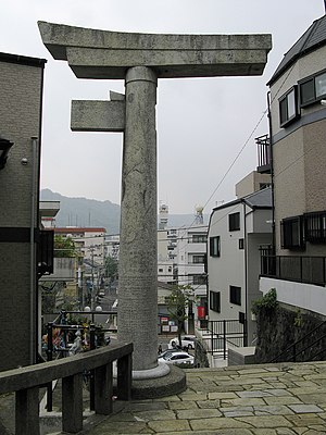
Sannō Shrine
Shinto shrine in Nagasaki, Japan
Distance: Approx. 1731 meters
Latitude and longitude: 32.7675,129.86861111
The Sannō Shrine (山王神社, Sannō Jinja, literally Mountain king shrine), located about 800 metres south-east of the atomic bomb hypocentre in Nagasaki, is noted for its one-legged stone torii at the shrine entrance.

Nagasaki Atomic Bomb Museum
Museum in Nagasaki, Japan
Distance: Approx. 1155 meters
Latitude and longitude: 32.77277778,129.865
The Nagasaki Atomic Bomb Museum (長崎原爆資料館, Nagasaki Genbaku Shiryōkan) is in the city of Nagasaki, Japan. The museum is a remembrance to the atomic bombing of Nagasaki by the United States on 9 August 1945 at 11:02:35 am. Next to the museum is the Nagasaki National Peace Memorial Hall for the Atomic Bomb Victims, built in 2003.

Nagasaki National Peace Memorial Hall for the Atomic Bomb Victims
Memorial monument in Nagasaki, Japan
Distance: Approx. 1155 meters
Latitude and longitude: 32.77277778,129.865
The Nagasaki National Peace Memorial Hall for the Atomic Bomb Victims (国立長崎原爆死没者追悼平和祈念館, Kokuritsu Nagasaki Genbaku Shibotsusha Tsuitō Heiwa Kinenkan) is a commemorative monument in Nagasaki, Japan, situated next to its Atomic Bomb Museum. The Peace Park is nearby. Like its counterpart in Hiroshima, the hall was constructed as a place to remember and pray for those who died in the 1945 atomic bombing, with photos, memoirs and personal accounts of the event.

Urakami Station
Railway station in Nagasaki, Nagasaki Prefecture, Japan
Distance: Approx. 1986 meters
Latitude and longitude: 32.765449,129.863292
Urakami Station (浦上駅, Urakami-eki) is a railway station in Kawaguchi-chō, Nagasaki, Nagasaki Prefecture, Japan. It is operated by JR Kyushu and is on the Nagasaki Main Line. It is the station where the old line and new line sections of the Nagasaki Line intersect.

Nagasaki Baseball Stadium
Distance: Approx. 923 meters
Latitude and longitude: 32.77677222,129.86058333
Nagasaki Baseball Stadium (長崎県営野球場, Nagasaki Ken'ei Yakyūjō, Nagasaki Big N Stadium) is a baseball stadium in the city of Nagasaki, Japan. The stadium was built in 1997 and has an all-seated capacity of 25,000. The Nagasaki Saints played some home games there.

Sakamoto International Cemetery
Cemetery in Nagasaki, Japan
Distance: Approx. 2005 meters
Latitude and longitude: 32.765,129.8679
The Sakamoto International Cemetery (坂本国際墓地, Sakamoto Kokusai Bochi) is located in Sakamoto in the Urakami area of the city of Nagasaki, Japan. The cemetery for foreigners was established following the 1888 closure of an earlier burial ground near the international quarter of the city. It is administered by the city government.

Nishi-Urakami Station
Railway station in Nagasaki, Nagasaki Prefecture, Japan
Distance: Approx. 1139 meters
Latitude and longitude: 32.79055556,129.85888889
Nishi-Urakami Station (西浦上駅, Nishi-Urakami-eki) is a railway station in Nagasaki, Nagasaki Prefecture, Japan. It is operated by JR Kyushu and is on the Nagasaki Main Line.

Michinoo Station
Railway station in Nagayo, Nagasaki Prefecture, Japan
Distance: Approx. 2738 meters
Latitude and longitude: 32.80444444,129.85277778
Michinoo Station (道ノ尾駅, Michinoo-eki) is a passenger railway station located in the town of Nagayo, Nishisonogi District, Nagasaki Prefecture, Japan. It is operated by JR Kyushu.
Weather in this IP's area
broken clouds
10 Celsius
9 Celsius
10 Celsius
10 Celsius
1025 hPa
93 %
1025 hPa
1023 hPa
10000 meters
1.54 m/s
70 degree
75 %