110.54.174.132 - IP Lookup: Free IP Address Lookup, Postal Code Lookup, IP Location Lookup, IP ASN, Public IP
Country:
Region:
City:
Location:
Time Zone:
Postal Code:
ISP:
ASN:
language:
User-Agent:
Proxy IP:
Blacklist:
IP information under different IP Channel
ip-api
Country
Region
City
ASN
Time Zone
ISP
Blacklist
Proxy
Latitude
Longitude
Postal
Route
db-ip
Country
Region
City
ASN
Time Zone
ISP
Blacklist
Proxy
Latitude
Longitude
Postal
Route
IPinfo
Country
Region
City
ASN
Time Zone
ISP
Blacklist
Proxy
Latitude
Longitude
Postal
Route
IP2Location
110.54.174.132Country
Region
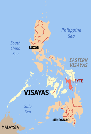
leyte
City
panalanoy
Time Zone
Asia/Manila
ISP
Language
User-Agent
Latitude
Longitude
Postal
ipdata
Country
Region
City
ASN
Time Zone
ISP
Blacklist
Proxy
Latitude
Longitude
Postal
Route
Popular places and events near this IP address

Tacloban
Highly-urbanized city and capital of Leyte, Philippines
Distance: Approx. 1420 meters
Latitude and longitude: 11.24,125
Tacloban ( tak-LOH-ban; Tagalog pronunciation: [tɐkˈloban]), officially the City of Tacloban (Waray: Syudad han Tacloban; Filipino: Lungsod ng Tacloban), is a highly urbanized city on Leyte island in the Eastern Visayas region of the Philippines. According to the 2020 census, Tacloban has a population of 251,881, making it the most populous city in the Eastern Visayas. The city is located 360 miles (580 km) southeast of Manila.
Divine Word University of Tacloban
Roman Catholic university in Tacloban, Philippines
Distance: Approx. 1336 meters
Latitude and longitude: 11.2406,125.00048
The Liceo del Verbo Divino, also referred to by its acronym LVD, is a private, Catholic, co-educational basic education institution run by the Philippine Southern Province of the Society of the Divine Word in Tacloban City, Philippines. It was founded by the Divine Word Missionaries in 1929. Liceo del Verbo Divino was formerly the Divine Word University of Tacloban.
University of the Philippines Tacloban
Public college in Leyte, Philippines
Distance: Approx. 321 meters
Latitude and longitude: 11.24833333,125.00722222
The University of the Philippines Tacloban (Waray: Unibersidad han Pilipinas ha Tacloban) is an autonomous college of the University of the Philippines system. It was established on May 23, 1973, at the city of Tacloban, Philippines.
Leyte Normal University
Public university in Leyte, Philippines
Distance: Approx. 1581 meters
Latitude and longitude: 11.23777778,125.00138889
Leyte Normal University (also abbreviated as LNU) is a university in the province of Leyte, Philippines. It is mandated to provide higher professional and special instruction for special purposes and to promote research and extension services, advanced studies, and progressive leadership in education and other related fields. Its campus is situated in Tacloban City.
Sangyaw
Religious event in the Philippines
Distance: Approx. 1034 meters
Latitude and longitude: 11.2419,125.0077
Sangyaw Festival is a religious and socio-cultural event in the Philippines. It was revived in 2008 by the city government of Tacloban, Philippines. Sangyaw means "to herald news" in Waray language.
JE Mondejar Foundation College
Private college in Tacloban, Philippines
Distance: Approx. 877 meters
Latitude and longitude: 11.2435,125.0043
JE Mondejar Foundation College (JEMFC) is a private school in Tacloban, Philippines. It was founded in 1990 by Jose Rene E. Mondejar as the JE Mondejar Computer College as a private trade school offering courses computer technology and electronic data processing to companies and government agencies. The school has since grown into a full four-year college and graduate school, offering bachelor's degrees in Computer Science, Information Technology, and Business Administration, associate degrees in various computer hardware and software technology areas, and certificate programs in commercial food service, as well as continuing to offer short courses in current computer technology.
Eastern Visayas Medical Center
Government hospital in Tacloban, Philippines
Distance: Approx. 192 meters
Latitude and longitude: 11.2515671,125.0047052
The Eastern Visayas Medical Center (EVMC) is a tertiary level teaching and training government hospital in the Philippines. On June 18, 1966, the then Speaker Daniel Z. Romualdez Memorial City Hospital was established as a general hospital in Tacloban with service capacity of one hundred beds. On July 22, 1972, the Speaker Daniel Z. Romualdez Memorial City Hospital became the surviving entity when the Leyte Provincial Hospital and the Tacloban City Hospital were merged with it.

Leyte Provincial Capitol
Capitol building of Leyte province in the Philippines
Distance: Approx. 287 meters
Latitude and longitude: 11.25046,125.00385
The Leyte Provincial Capitol was the seat of government of the Philippine province of Leyte until 2019. The historic building situated in Tacloban also served as the temporary national capitol from 1944 to 1945 during the World War II era.
Divine Word Hospital
Private hospital in Tacloban, Philippines
Distance: Approx. 1327 meters
Latitude and longitude: 11.24086,125.00017
The Divine Word Hospital also known as Saint Arnold Medical Mission, Inc. is a DOH-accredited level 3 general hospital in Tacloban, Philippines. Formerly known as St.

Leyte–Samar Naval Base
Major World War II base
Distance: Approx. 1493 meters
Latitude and longitude: 11.250939,124.992726
Leyte–Samar Naval Base was a large United States Navy base in the Philippines on the Islands of Leyte, Samar and the San Pedro Bay. The base was built during World War II to support the many naval ships fighting and patrolling in the South West Pacific theatre of war as part of the Pacific War. A number of naval facilities were built on the east coast of Leyte island starting October 20, 1944.

Santo Niño Church (Tacloban)
Roman Catholic church in Tacloban, Philippines
Distance: Approx. 1078 meters
Latitude and longitude: 11.24144,125.00571
The Archdiocesan Shrine of Santo Niño, also known as Santo Niño Church, is a Roman Catholic church in Tacloban, Philippines. It is under the jurisdiction of the Archdiocese of Palo.

Price Mansion
Distance: Approx. 832 meters
Latitude and longitude: 11.24394444,125.00419444
The Price Mansion is a historic house in Tacloban, Philippines.
Weather in this IP's area
broken clouds
25 Celsius
26 Celsius
25 Celsius
25 Celsius
1009 hPa
90 %
1009 hPa
1005 hPa
10000 meters
1.4 m/s
2.49 m/s
34 degree
57 %
