110.54.155.246 - IP Lookup: Free IP Address Lookup, Postal Code Lookup, IP Location Lookup, IP ASN, Public IP
Country:
Region:
City:
Location:
Time Zone:
Postal Code:
ISP:
ASN:
language:
User-Agent:
Proxy IP:
Blacklist:
IP information under different IP Channel
ip-api
Country
Region
City
ASN
Time Zone
ISP
Blacklist
Proxy
Latitude
Longitude
Postal
Route
db-ip
Country
Region
City
ASN
Time Zone
ISP
Blacklist
Proxy
Latitude
Longitude
Postal
Route
IPinfo
Country
Region
City
ASN
Time Zone
ISP
Blacklist
Proxy
Latitude
Longitude
Postal
Route
IP2Location
110.54.155.246Country
Region
pangasinan
City
carmen
Time Zone
Asia/Manila
ISP
Language
User-Agent
Latitude
Longitude
Postal
ipdata
Country
Region
City
ASN
Time Zone
ISP
Blacklist
Proxy
Latitude
Longitude
Postal
Route
Popular places and events near this IP address
Villasis
Municipality in Pangasinan, Philippines
Distance: Approx. 2836 meters
Latitude and longitude: 15.9,120.58
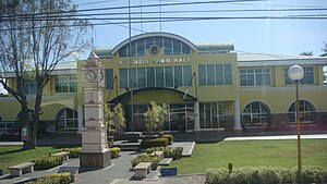
Villasis, officially the Municipality of Villasis (Pangasinan: Baley na Villasis; Ilocano: Ili ti Villasis; Tagalog: Bayan ng Villasis), is a municipality in the province of Pangasinan, Philippines. According to the 2020 census, it has a population of 65,047 people.
Alcala, Pangasinan
Municipality in Pangasinan, Philippines
Distance: Approx. 9305 meters
Latitude and longitude: 15.846794,120.521822
Alcala, officially the Municipality of Alcala (Pangasinan: Baley na Alcala; Ilocano: Ili ti Alcala; Tagalog: Bayan ng Alcala), is a municipality in the province of Pangasinan, Philippines. According to the 2020 census, it has a population of 48,908 people. Alcala recently broke the world record for longest grill measuring about 3 kilometres (9,840 ft).
Rosales, Pangasinan
Municipality in Pangasinan, Philippines
Distance: Approx. 3722 meters
Latitude and longitude: 15.89444,120.63278
Rosales ([ɾɔˈsalɛs]), officially the Municipality of Rosales (Pangasinan: Baley na Rosales; Ilocano: Ili ti Rosales; Tagalog: Bayan ng Rosales), is a municipality in the province of Pangasinan, Philippines. According to the 2020 census, it has a population of 66,711 people. It is sometimes called Carmen, based on its prominent barangay of the same name (now split into two barangays).
Santo Tomas, Pangasinan
Municipality in Pangasinan, Philippines
Distance: Approx. 1333 meters
Latitude and longitude: 15.8792,120.5883
Santo Tomas, officially the Municipality of Santo Tomas (Pangasinan: Baley na Santo Tomas; Ilocano: Ili ti Santo Tomas; Tagalog: Bayan ng Santo Tomas), is a municipality in the province of Pangasinan, Philippines. According to the 2020 census, it has a population of 14,878 people, making it the least populated municipality in the province. Santo Tomas is 58 kilometres (36 mi) from Lingayen and 172 kilometres (107 mi) from Manila.
San Manuel, Tarlac
Municipality in Tarlac, Philippines
Distance: Approx. 9582 meters
Latitude and longitude: 15.7975,120.6072
San Manuel, officially the Municipality of San Manuel (Ilocano: Ili ti San Manuel; Pangasinan: Baley na San Manuel; Tagalog: Bayan ng San Manuel), is a municipality in the province of Tarlac, Philippines. According to the 2020 census, it has a population of 28,387 people.

SM City Rosales
Shopping mall in Pangasinan, Philippines
Distance: Approx. 512 meters
Latitude and longitude: 15.87933,120.60242
SM City Rosales is a shopping mall owned by SM Prime Holdings located along MacArthur Highway in barangay Carmen East, Rosales, Pangasinan. It opened on November 28, 2008, and is the first SM Supermall in the province of Pangasinan and in Ilocos Region. The mall has a land area of 121,685 m2 (1,309,810 sq ft) and a total gross floor area of 60,989 m2 (656,480 sq ft).
Rosales Airport
Place in Negros Island Region, Philippines
Distance: Approx. 540 meters
Latitude and longitude: 15.885,120.60472222
Rosales Airport is an airfield located in Rosales, Pangasinan, in the Philippines. It is listed by the Civil Aviation Authority of the Philippines for operation of rotary aircraft only. The airfield was constructed in October 1941, on the eve of the Japanese invasion of the Philippines, initially as a dirt landing strip.

Urdaneta Philippines Temple
Latter-day Saint temple in Pangasinan, Philippines
Distance: Approx. 6443 meters
Latitude and longitude: 15.9385,120.5819
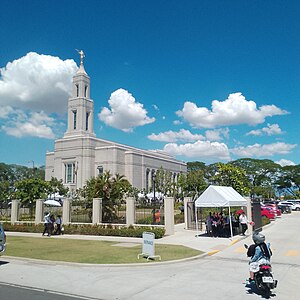
The Urdaneta Philippines Temple is the 190th temple of the Church of Jesus Christ of Latter-day Saints, located in Urdaneta City, Pangasinan, Philippines. The intent to build the temple was announced on October 2, 2010, by church president Thomas S. Monson, during general conference. The temple is the third in the Philippines, following those in Manila and Cebu City.
San Aurelio National High School
School
Distance: Approx. 9413 meters
Latitude and longitude: 15.89583333,120.68694444
The San Aurelio National High School (SANHS) is a Public High School and a National High School, Located in Eastern District of Pangasinan, Ilocos region, and it was the first operating Public High School in the town of Balungao Balungao, Pangasinan. It was founded on 1967 as a Semi-private institution formerly located in the elementary school, it is known as San Aurelio Barangay High School until it was officially changed to San Aurelio National High School because of the increasing number of student from neighboring towns. It was moved from the Elementary school to the location where it was now located.
Mount Balungao
Inactive volcano in Pangasinan, Philippines
Distance: Approx. 9132 meters
Latitude and longitude: 15.8625,120.6825
Mount Balungao is an isolated inactive volcano located in Pangasinan, on the island of Luzon in the Philippines. Rising to a height of 382 metres (1,253 ft) ASL, it is located in the town of Balungao, about 5 kilometres (3.1 mi) from the town center. It is the main tourist attraction of the town, along with the Balungao Hot and Cold Spring Resort nearby.
Conrado F. Estrella Regional Medical and Trauma Center
Government hospital in Pangasinan, Philippines
Distance: Approx. 3611 meters
Latitude and longitude: 15.90707,120.62295
The Conrado F. Estrella Regional Medical and Trauma Center is a government hospital in the Philippines. It is located in Rosales, Pangasinan.
Weather in this IP's area
scattered clouds
24 Celsius
25 Celsius
24 Celsius
24 Celsius
1009 hPa
82 %
1009 hPa
1012 hPa
10000 meters
2.8 m/s
5.87 m/s
296 degree
50 %


