Country:
 The Philippines
Region:
City:
Latitude and Longitude:
Time Zone:
Postal Code:
IP information under different IP Channel
ip-api
Country
Region
City
ASN
Time Zone
ISP
Blacklist
Proxy
Latitude
Longitude
Postal
Route
IPinfo
Country
Region
City
ASN
Time Zone
ISP
Blacklist
Proxy
Latitude
Longitude
Postal
Route
MaxMind
Country
Region
City
ASN
Time Zone
ISP
Blacklist
Proxy
Latitude
Longitude
Postal
Route
Luminati
Country
PHRegion
00
City
caloocancity
ASN
Time Zone
Asia/Manila
ISP
Globe Telecom Inc.
Latitude
Longitude
Postal
db-ip
Country
Region
City
ASN
Time Zone
ISP
Blacklist
Proxy
Latitude
Longitude
Postal
Route
ipdata
Country
Region
City
ASN
Time Zone
ISP
Blacklist
Proxy
Latitude
Longitude
Postal
Route
Popular places and events near this IP address
Caloocan
Highly urbanized city in Metro Manila, Philippines
Distance: Approx. 1006 meters
Latitude and longitude: 14.65,120.97
Caloocan, officially the City of Caloocan (Filipino: Lungsod ng Kalookan; IPA: [kalɔˈʔokan]), is a highly urbanized city in Metro Manila, Philippines. According to the 2020 census, it has a population of 1,661,584 people making it the fourth-most populous city in the Philippines. Caloocan is divided into two geographical locations with a total combined area of 5,333.40 hectares (13,179.1 acres), a result of the 1949 expansion of Quezon City, which absorbed much of its territory.

Westminster High School (Manila)
Private Chinese high school in Manila, Philippines
Distance: Approx. 994 meters
Latitude and longitude: 14.635,120.96166
Westminster High School (simplified Chinese: 培元中学; traditional Chinese: 培元中學; pinyin: Péiyuán Zhōngxué; Pe̍h-ōe-jī: Pôe-goân Tiong-o̍h / Pôe-oân Tiong-o̍h; acronym: WHS), founded by Madam Elizabeth Kho in 1935, is a private, Chinese, Christian educational institution in Manila, Philippines. It has a sister-school under the same name in Taiwan. Since the 1930s, the school had been offering Chinese courses from kindergarten up to high school, however, in 2001, it abolished the Chinese curriculum and ceased from participating in sports competitions with other Chinese schools in Metro Manila.
Smokey Mountain
Landfill in Manila
Distance: Approx. 1327 meters
Latitude and longitude: 14.63222222,120.96027778
Smokey Mountain was the term coined for a large landfill once located in Tondo, Manila.

Navotas Polytechnic College
Public college in Navotas, Philippines
Distance: Approx. 673 meters
Latitude and longitude: 14.64499,120.95707
The Navotas Polytechnic College also referred to by its acronym NPC, is a public, non-sectarian, coeducational higher education institution run by the city government of Navotas in Navotas City, Metro Manila, Philippines. It was founded in 1994 by virtue of Municipal Ordinance (M.O). No.

Tondo Medical Center
Government hospital in Manila, Philippines
Distance: Approx. 971 meters
Latitude and longitude: 14.63508,120.96311
The Tondo Medical Center, also known as Tondo Med, is a 300-bed capacity tertiary public medical center established in 1971, under the supervision and control of the Department of Health (DOH). It is located on North Bay Boulevard, Tondo, Manila, Philippines.

5th Avenue station (PNR)
Distance: Approx. 1392 meters
Latitude and longitude: 14.64444444,120.97611111
5th Avenue station (also called C-3 station) is a railway station located on the North Main Line in Caloocan, Metro Manila, Philippines. Facilities such as ramps and platforms were planned to be constructed near the level crossing with C-3 Road. The plans to rehabilitate this part of PNR's network were implemented but no concrete platforms were erected.

10th Avenue station (PNR)
Distance: Approx. 1527 meters
Latitude and longitude: 14.65159722,120.97486944
10th Avenue station (also called Asistio Avenue station) is a railway station located on the North Main Line in Caloocan, Metro Manila, Philippines, near the original Caloocan railway station. The station was meant to be a part of a revived commuter rail system, built during the term of Gloria Macapagal Arroyo. After being constructed, no services to this station were ever provided until August 1, 2018, when it was opened for the Caloocan-Dela Rosa shuttle line.

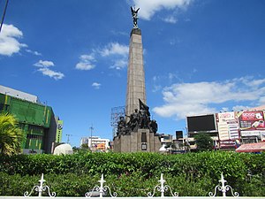
Battle of Caloocan
1899 battle of the Philippine–American War
Distance: Approx. 785 meters
Latitude and longitude: 14.65,120.96666667
The battle of Caloocan was one of the opening engagements of the Philippine–American War, and was fought between an American force under the command of Arthur MacArthur Jr. and Filipino defenders led by Antonio Luna in February 1899. American troops launched a successful attack on the Filipino-held settlement of Caloocan on February 10, which was part of an offensive planned by MacArthur Jr.

Caloocan Cathedral
Roman Catholic church in Caloocan, Philippines
Distance: Approx. 1259 meters
Latitude and longitude: 14.65027778,120.97277778
San Roque Cathedral Parish, commonly known as Caloocan Cathedral, is the cathedral or seat of the Roman Catholic Diocese of Kalookan, located near the intersection of 10th Avenue and A. Mabini Street in Poblacion, Caloocan, Metro Manila, Philippines. The church is located some meters away from the poblacion or central vicinity of the city. Its present parish priest is Pablo Virgilio S. David, the Bishop of Kalookan, and its rector is Jeronimo Maria J. Cruz.

North Bay Boulevard
Main road in Navotas, Philippines
Distance: Approx. 947 meters
Latitude and longitude: 14.6430556,120.9544444
North Bay Boulevard is a 2.34-kilometer-long (1.45 mi) two- to four-lane access road in the Navotas Fish Port Complex of northern Metro Manila, Philippines. It is one of the main roads in Navotas which travels north-south through the southern parts of the city running parallel to Radial Road 10 (R-10) to the west. The road links the Balut area of Tondo in Manila and San Rafael Village in the south to the central Navotas barangay of Bagumbayan South in the north.

Estero de Vitas
River in Manila, Philippines
Distance: Approx. 1642 meters
Latitude and longitude: 14.629384,120.959977
The Estero de Vitas is one of the rivulets, known as esteros, which delineated the small islands which historically constituted the city of Manila and its predecessors, the Tagalog polities (called bayan) of Maynila and Tondo. These esteros, along with the larger rivers of Manila Bay and the Pasig River delta, originally formed an important connecting network which allowed the precolonial polities of that Tagalog and Kapampangan peoples. The Estero de Vitas drains water from Manila as far as Tayuman Street, and then dumps water directly to Manila Bay.
CAMANA Water Reclamation Facility
Sewage treatment plant in Caloocan, Philippines
Distance: Approx. 972 meters
Latitude and longitude: 14.6375,120.96944444
The Caloocan–Malabon–Navotas (CAMANA) Water Reclamation Facility is a sewage treatment plant under-construction in Caloocan, Metro Manila, Philippines. If completed, it will become the largest sewage treatment plant in the Philippines with a capacity to process 205 million liters (54,000,000 U.S. gal) of used water daily. The groundbreaking ceremony for the CAMANA Water Reclamation Facility project of Maynilad was held in November 2019, but actual construction was announced to have started in March 2021.
Weather in this IP's area
scattered clouds
29 Celsius
34 Celsius
28 Celsius
29 Celsius
1010 hPa
82 %
1010 hPa
1009 hPa
10000 meters
1.03 m/s
40 %
05:47:50
17:34:26