110.5.126.207 - IP Lookup: Free IP Address Lookup, Postal Code Lookup, IP Location Lookup, IP ASN, Public IP
Country:
Region:
City:
Location:
Time Zone:
Postal Code:
IP information under different IP Channel
ip-api
Country
Region
City
ASN
Time Zone
ISP
Blacklist
Proxy
Latitude
Longitude
Postal
Route
Luminati
Country
Region
20
City
chino
ASN
Time Zone
Asia/Tokyo
ISP
LCV Corporation
Latitude
Longitude
Postal
IPinfo
Country
Region
City
ASN
Time Zone
ISP
Blacklist
Proxy
Latitude
Longitude
Postal
Route
IP2Location
110.5.126.207Country
Region
nagano
City
matsumoto
Time Zone
Asia/Tokyo
ISP
Language
User-Agent
Latitude
Longitude
Postal
db-ip
Country
Region
City
ASN
Time Zone
ISP
Blacklist
Proxy
Latitude
Longitude
Postal
Route
ipdata
Country
Region
City
ASN
Time Zone
ISP
Blacklist
Proxy
Latitude
Longitude
Postal
Route
Popular places and events near this IP address

Matsumoto, Nagano
Core city in Nagano, Chūbu, Japan
Distance: Approx. 705 meters
Latitude and longitude: 36.238,137.97197222
Matsumoto (松本市, Matsumoto-shi) is a city located in Nagano Prefecture, Japan. Matsumoto is designated as a core city since 1 April 2021. As of 1 March 2019, the city had a population of 239,466 in 105,207 households and a population density of 240 persons per km2.

Matsumoto Castle
Castle in the Nagano Prefecture, Japan
Distance: Approx. 673 meters
Latitude and longitude: 36.23888889,137.96916667
Matsumoto Castle (松本城, Matsumoto-jō), originally known as Fukashi Castle, is one of Japan's premier historic castles, along with Himeji and Kumamoto. It was the seat of Matsumoto Domain under the Edo Period Tokugawa shogunate. It is located in the city of Matsumoto, in Nagano Prefecture.
Matsumoto sarin attack
1994 attempted assassination by Aum Shinrikyo
Distance: Approx. 1177 meters
Latitude and longitude: 36.243,137.9716
The Matsumoto sarin attack was an attempted assassination perpetrated by members of the Aum Shinrikyo doomsday cult in Matsumoto, Nagano Prefecture, Japan on the night of June 27, 1994. Eight people were killed and more than 500 were harmed by sarin aerosol that was released from a converted refrigerator truck in the Kaichi Heights area. The attack was perpetrated nine months before the better-known Tokyo subway sarin attack.

Siege of Fukashi
1550 siege
Distance: Approx. 662 meters
Latitude and longitude: 36.2388,137.9691
The 1550 siege of Fukashi was one of a series of battles waged by Takeda Shingen in his long campaign to conquer Shinano province, which was ruled by a number of minor daimyō, notably the Suwa, Ogasawara, Murakami and Takato. Shingen mounted his first invasion of Shinano in 1542 and steadily worked his way northwards, defeating the Suwa and Takato by 1547. His inexorable advance through the province alarmed the Uesugi clan, which controlled Echigo province to the north, and in 1547 Uesugi Norimasa sent an army into the province to confront Shingen, but this was swept aside at Odaihara.

Shinshu University
Japanese national university in Matsumoto, Nagano Prefecture, Japan
Distance: Approx. 2271 meters
Latitude and longitude: 36.25111111,137.97888889
Shinshu University (信州大学, Shinshū daigaku), abbreviated to Shindai (信大), is a Japanese national university located in Matsumoto, Nagano Prefecture, Japan. As the only national university in Japan bearing the name of a former Japanese province, it bears the name "Shinshu" (alternative name for Shinano Province), and is firmly rooted in the many regions of Nagano Prefecture. It was the 18th ranked higher education institution in Japan.

Matsumoto Bus Terminal
Bus terminal in Matsumoto, Nagano, Japan
Distance: Approx. 315 meters
Latitude and longitude: 36.23027778,137.96669444
Matsumoto Bus Terminal (松本バスターミナル, Matsumoto Basu Tāminaru) is a bus terminal to the east of Matsumoto Station in Matsumoto, Nagano, Japan, managed by Alpico Kōtsū.

Matsumoto Station
Railway station in Matsumoto, Nagano Prefecture, Japan
Distance: Approx. 402 meters
Latitude and longitude: 36.2305,137.9639
Matsumoto Station (松本駅, Matsumoto-eki) is a train station in the city of Matsumoto, Nagano Prefecture, Japan, operated by East Japan Railway Company (JR East), and the private railway operator Alpico Kōtsū.
Kita-Matsumoto Station
Railway station in Matsumoto, Nagano Prefecture, Japan
Distance: Approx. 693 meters
Latitude and longitude: 36.2368,137.9608
Kita-Matsumoto Station (北松本駅, Kita-Matsumoto-eki) is a train station in the city of Matsumoto, Nagano Prefecture, Japan, operated by East Japan Railway Company (JR East).

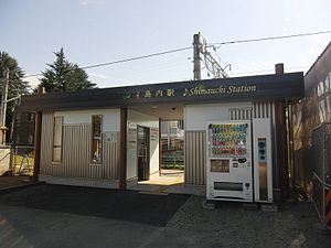
Shimauchi Station
Railway station in Matsumoto, Nagano Prefecture, Japan
Distance: Approx. 2510 meters
Latitude and longitude: 36.2468,137.9448
Shimauchi Station (島内駅, Shimauchi-eki) is a train station in the city of Matsumoto, Nagano Prefecture, Japan, operated by East Japan Railway Company (JR East).

Kaichi School
Distance: Approx. 1145 meters
Latitude and longitude: 36.24333333,137.96833333
The Kaichi School (旧開智学校, kyūkaichi-gakkō) in Matsumoto, Nagano Prefecture was one of the first schools in Japan. It opened in a temporary building in May 1873, the year after the first major education reforms were introduced by the new Ministry of Education. The school moved to new premises in April 1876.

Shinano-Arai Station
Railway station in Matsumoto, Nagano Prefecture, Japan
Distance: Approx. 1680 meters
Latitude and longitude: 36.22891667,137.94901944
Shinano-Arai Station (信濃荒井駅, Shinano-Arai-eki) is a railway station in the city of Matsumoto, Nagano, Japan, operated by the private railway operating company Alpico Kōtsū.

Nishi-Matsumoto Station
Railway station in Matsumoto, Nagano Prefecture, Japan
Distance: Approx. 738 meters
Latitude and longitude: 36.22712778,137.96343611
Nishi-Matsumoto Station (西松本駅, Nishi-Matsumoto-eki) is a railway station in the city of Matsumoto, Nagano, Japan, operated by the private railway operating company Alpico Kōtsū.
Weather in this IP's area
broken clouds
2 Celsius
2 Celsius
1 Celsius
2 Celsius
1018 hPa
63 %
1018 hPa
898 hPa
10000 meters
0.89 m/s
1.34 m/s
303 degree
75 %
