110.5.124.104 - IP Lookup: Free IP Address Lookup, Postal Code Lookup, IP Location Lookup, IP ASN, Public IP
Country:
Region:
City:
Location:
Time Zone:
Postal Code:
IP information under different IP Channel
ip-api
Country
Region
City
ASN
Time Zone
ISP
Blacklist
Proxy
Latitude
Longitude
Postal
Route
Luminati
Country
Region
20
City
chino
ASN
Time Zone
Asia/Tokyo
ISP
LCV Corporation
Latitude
Longitude
Postal
IPinfo
Country
Region
City
ASN
Time Zone
ISP
Blacklist
Proxy
Latitude
Longitude
Postal
Route
IP2Location
110.5.124.104Country
Region
nagano
City
chino
Time Zone
Asia/Tokyo
ISP
Language
User-Agent
Latitude
Longitude
Postal
db-ip
Country
Region
City
ASN
Time Zone
ISP
Blacklist
Proxy
Latitude
Longitude
Postal
Route
ipdata
Country
Region
City
ASN
Time Zone
ISP
Blacklist
Proxy
Latitude
Longitude
Postal
Route
Popular places and events near this IP address

Suwa, Nagano
City in Chūbu, Japan
Distance: Approx. 6460 meters
Latitude and longitude: 36.03913889,138.11402778
Suwa (諏訪市, Suwa-shi) is a city located in Nagano Prefecture, Japan. As of 1 March 2019, the city had an estimated population of 48,972 in 20698 households, and a population density of 452 persons per km². The total area of the city is 109.17 square kilometres (42.15 sq mi).

Chino, Nagano
City in Chūbu, Japan
Distance: Approx. 890 meters
Latitude and longitude: 35.99552778,138.15880556
Chino (茅野市, Chino-shi) is a city located in Nagano Prefecture, Japan. As of 1 March 2019, the city had an estimated population of 55,673 in 23,236 households, and a population density of 210 persons per km². The total area of the city is 266.59 square kilometres (102.93 sq mi).

Hara, Nagano
Village in Chūbu, Japan
Distance: Approx. 6026 meters
Latitude and longitude: 35.96438889,138.21738889
Hara (原村, Hara-mura) is a village located in Nagano Prefecture, Japan. As of 1 February 2019, the village had an estimated population of 7,661 in 2445 households, and a population density of 174 persons per km2. The total area of the village is 43.26 square kilometres (16.70 sq mi).
Siege of Uehara
1541 siege
Distance: Approx. 1896 meters
Latitude and longitude: 36.00884806,138.14900611
The siege of Uehara was the first of many steps taken by Takeda Shingen in his bid to seize control of Shinano Province. Uehara Castle had been controlled by Suwa Yorishige before it was taken by Shingen.
Siege of Kuwabara
1542 siege
Distance: Approx. 3782 meters
Latitude and longitude: 36.02583333,138.13972222
The siege of Kuwabara took place the day after the siege of Uehara; Takeda Shingen continued to gain power in Shinano Province by seizing Kuwabara castle from Suwa Yorishige.

Chino Station
Railway station in Chino, Nagano Prefecture, Japan
Distance: Approx. 1549 meters
Latitude and longitude: 35.9947,138.1511
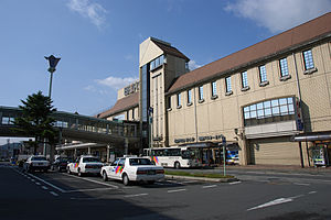
Chino Station (茅野駅, Chino-eki) is a railway station on the Chūō Main Line in the city of Chino, Nagano, Japan, operated by East Japan Railway Company (JR East).

Kuwabara Castle
Distance: Approx. 3782 meters
Latitude and longitude: 36.02583333,138.13972222
Kuwabara Castle (桑原城, Kuwabara-jō), also known as Takatoya Castle and Suisho Castle, is a yamashiro (castle located on a mountain) situated in Suwa, Nagano Prefecture, Japan. The castle was constructed sometime in the fifteenth century by the Kuwabara clan. By the time it came under the control of the Suwa clan, it had become a satellite castle to Uehara Castle.

Suwa University of Science
University in Nagano, Japan
Distance: Approx. 1619 meters
Latitude and longitude: 36.00825,138.18180556
Suwa University of Science (公立諏訪東京理科大学, Suwa tokyo rika daigaku) is a formerly private university now public (municipal) in Chino, Nagano, Japan. The school opened as a junior college in 1990. It became a four-year college in 2002.

Takashima Castle
Japanese castle
Distance: Approx. 6643 meters
Latitude and longitude: 36.03979167,138.11201944
Takashima Castle (高島城, Takashima-jō) is a Japanese castle located in Suwa, central Nagano Prefecture, Japan. At the end of the Edo period, Takashima Castle was home to the Suwa clan, daimyō of Takashima Domain.
Togariishi Museum of Jōmon Archaeology
Museum in Chino, Nagano Prefecture, Japan
Distance: Approx. 6194 meters
Latitude and longitude: 36.01348,138.233732
The Togariishi Museum of Jōmon Archaeology (茅野市尖石縄文考古館, Chino-shi Togariishi Jōmon Kōkokan) is a municipal museum located in the city of Chino, Nagano Prefecture, Japan, specializing in artifacts of the Jōmon period (between 14,000 and 1000 BCE).
Akyū ruins
Ruins of a Jōmon period settlement in Hara, Japan
Distance: Approx. 4372 meters
Latitude and longitude: 35.96472222,138.18833333
The Akyū ruins (阿久遺跡, Akyū iseki) is an archaeological site containing the ruins of a large-scale Jōmon period settlement located in the Kawagishi neighborhood of the village of Hara, Suwa District, Nagano in the Chūbu region of Japan. It contains the largest stone circle yet found in Japan. The site was designated a National Historic Site of Japan in 1979.

Komagata ruins
Archaeological site in Japan
Distance: Approx. 4823 meters
Latitude and longitude: 36.03944444,138.18916667
The Komagata Ruins (駒形遺跡, Komagata iseki) is an archaeological site containing the ruins of a Jōmon period settlement located in the Yonezawa neighborhood of the city of Chino, Nagano in the Chūbu region of Japan. The site was designated a National Historic Site of Japan in 1998.
Weather in this IP's area
overcast clouds
1 Celsius
-1 Celsius
-0 Celsius
1 Celsius
1018 hPa
44 %
1018 hPa
878 hPa
10000 meters
1.85 m/s
3.87 m/s
208 degree
100 %

