Country:
 Pakistan
Region:
City:
Latitude and Longitude:
Time Zone:
Postal Code:
IP information under different IP Channel
ip-api
Country
Region
City
ASN
Time Zone
ISP
Blacklist
Proxy
Latitude
Longitude
Postal
Route
IPinfo
Country
Region
City
ASN
Time Zone
ISP
Blacklist
Proxy
Latitude
Longitude
Postal
Route
MaxMind
Country
Region
City
ASN
Time Zone
ISP
Blacklist
Proxy
Latitude
Longitude
Postal
Route
Luminati
Country
PKASN
Time Zone
Asia/Karachi
ISP
National WiMAXIMS environment
Latitude
Longitude
Postal
db-ip
Country
Region
City
ASN
Time Zone
ISP
Blacklist
Proxy
Latitude
Longitude
Postal
Route
ipdata
Country
Region
City
ASN
Time Zone
ISP
Blacklist
Proxy
Latitude
Longitude
Postal
Route
Popular places and events near this IP address
Walton Airport
Airport in Lahore, Pakistan
Distance: Approx. 1692 meters
Latitude and longitude: 31.49472222,74.34611111
Walton Airport (ICAO: OPLH), also known as Walton Airfield, is situated near Model Town, 10 km (6 mi) from the city centre of Lahore, in Punjab province of Pakistan. It was founded in 1918 and is named after Sir Colonel Cusack Walton. The airport was active until 1962.
Civil Services Academy
Civil service training academy in Lahore, Pakistan
Distance: Approx. 1060 meters
Latitude and longitude: 31.4908,74.358
Situated in Lahore, Pakistan, the Civil Services Academy Lahore is an academy for training the young bureaucrats of the country who are commissioned by the Federal Public Service Commission (FPSC) through a very competitive and tough exam known as Central superior services exam abbreviated as "CSS", (Urdu: لاہوراکادمی برائے تربیتِ دیوانی ملازمین) was established in 1948 (on the advice of first governor general of Pakistan Mr.Muhammad Ali jinnah) for the training of fresh entrants to the Bureaucracy of Pakistan Central superior services and was originally called Pakistan Administrative Services Academy. With the adoption of Civil Services Pakistan Resolution, the Academy was renamed as Civil Services Academy and the campus was shifted from an old building on the Race Course Road to the Old Residency Estate on Mall Road. Meanwhile, in addition to the new recruits of Civil Services of Pakistan (CSP), the academy started training the new employees of Foreign Services of Pakistan in 1963.

Walton railway station (Pakistan)
Railway station in Punjab, Pakistan
Distance: Approx. 651 meters
Latitude and longitude: 31.4874,74.3542
Walton Railway Station (Urdu: والٹن ریلوے اسٹیشن) is located in Walton cantonment, Lahore district of Pakistan's Punjab province. It is named after Sir Cusach Walton, son of Frederick Walton.
Bab-e-Pakistan
Monument in Punjab, Pakistan
Distance: Approx. 146 meters
Latitude and longitude: 31.48194444,74.35361111
The Bab-e-Pakistan (Urdu: بابِ پاكستان , lit. 'Gateway of Pakistan') is a national monument in Lahore, Punjab, Pakistan which is being built on the site of one of the major Muslim refugee camps which operated in the aftermath of independence of Pakistan. The memorial was proposed in 1985, by the late Governor Ghulam Jilani Khan, and was approved immediately by the President Muhammad Zia-ul-Haq. The monument is designed by a Lahore-based architect Amjad Mukhtar, who is a graduate from National College of Arts, Lahore.
Walton Cantonment
Distance: Approx. 651 meters
Latitude and longitude: 31.487382,74.354095
Walton Cantonment is a cantonment area situated in Lahore, Punjab, Pakistan. It is named after Sir Cusach Walton, son of British railway engineer Frederick Walton.
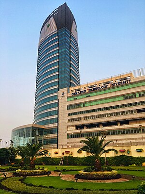
Arfa Software Technology Park
Skyscraper and technology park in Lahore, Pakistan
Distance: Approx. 1337 meters
Latitude and longitude: 31.475357,74.343064
Arfa Software Technology Park (previously known as Software Technology Park) is a skyscraper building and information technology park at Ferozepur Road, Lahore, Pakistan. Built in 2009, it is home to the Information Technology University and PITB. The main building consists of 17 floors and, at 106 meters tall, is currently the tallest building in Lahore. On 15 January 2012, Chief Minister of Punjab Mian Shahbaz Sharif announced a name change of Software Technology Park to Arfa Software Technology Park after the youngest Microsoft Certified Professional Arfa Karim, who died at the age of 16.
Kot Lakhpat
Neighbourhood in Lahore, Punjab, Pakistan
Distance: Approx. 2442 meters
Latitude and longitude: 31.46583333,74.33722222
Kot Lakhpat (Punjabi language, Urdu: کوٹ لکھپت) is a largely residential neighborhood and union council of Gulberg Tehsil in Lahore, Punjab, Pakistan. The neighborhood is both a residential and industrial area. It is located at 31° 27' 57N 74° 20' 14E. Kot Lakhpat is bordered by the Defence Housing Society to the east and Lahore Township to the west.
Children Hospital, Lahore
Hospital in Punjab, Pakistan
Distance: Approx. 1161 meters
Latitude and longitude: 31.4801,74.343
Children's Hospital and Institute of Child Health, established in May 1995, is a public children's hospital located on Ferozepur Road, Lahore, Punjab, Pakistan. The institution comes under Punjab Health Department.
Gulab Devi Chest Hospital
Hospital in Punjab, Pakistan
Distance: Approx. 1221 meters
Latitude and longitude: 31.4827,74.3423
Gulab Devi Chest Hospital is a 1,500 bed semi-private tertiary care chest hospital located in Ferozepur Road, Lahore, Punjab, Pakistan. The hospital was established in 1934 by Indian freedom fighter Lala Lajpat Rai in the memory of his mother, Gulab Devi, who died due to tuberculosis in 1927. The hospital is affiliated with Fatima Jinnah Medical College as a teaching hospital and is also affiliated with College of Physicians and Surgeons of Pakistan, as well as with Postgraduate Medical Institute (PGMI) and Ameer-ud-Din Medical College, both of which are affiliated with University of Health Sciences, Lahore.
Gulab Devi Postgraduate Medical Institute
Distance: Approx. 1222 meters
Latitude and longitude: 31.48124,74.34224
Gulab Devi Postgraduate Medical Institute (abbreviated as only GPMI), established in 2004, is a postgraduate training institute for medical and health care professionals located in Lahore, Punjab, Pakistan. Gulab Devi Chest Hospital is attached to it as a training and teaching hospital. The institute is accredited for training in FCPS Cardiology by the College of Physicians and Surgeons of Pakistan.
2017 Lahore explosion
Distance: Approx. 2291 meters
Latitude and longitude: 31.47372222,74.37738889
An explosion took place at around 10am on 23 February 2017 in a commercial market in Y-block of Defence, Lahore, Punjab, Pakistan, killing 10 people.
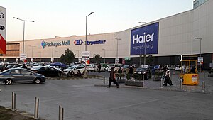
Packages Mall
Shopping mall in Walton, Lahore, Pakistan
Distance: Approx. 1141 meters
Latitude and longitude: 31.47138889,74.35611111
Packages Mall is a shopping mall located in Lahore, Pakistan. It is among the largest malls in Pakistan, and is owned and operated by Packages Limited.
Weather in this IP's area
smoke
28 Celsius
31 Celsius
25 Celsius
28 Celsius
1004 hPa
69 %
1004 hPa
980 hPa
4000 meters
1.54 m/s
250 degree
20 %
05:47:21
18:07:41